Home PageAbout MindatThe Mindat ManualHistory of MindatCopyright StatusWho We AreContact UsAdvertise on Mindat
Donate to MindatCorporate SponsorshipSponsor a PageSponsored PagesMindat AdvertisersAdvertise on Mindat
Learning CenterWhat is a mineral?The most common minerals on earthInformation for EducatorsMindat ArticlesThe ElementsThe Rock H. Currier Digital LibraryGeologic Time
Minerals by PropertiesMinerals by ChemistryAdvanced Locality SearchRandom MineralRandom LocalitySearch by minIDLocalities Near MeSearch ArticlesSearch GlossaryMore Search Options
The Mindat ManualAdd a New PhotoRate PhotosLocality Edit ReportCoordinate Completion ReportAdd Glossary Item
Mining CompaniesStatisticsUsersMineral MuseumsClubs & OrganizationsMineral Shows & EventsThe Mindat DirectoryDevice SettingsThe Mineral Quiz
Photo SearchPhoto GalleriesSearch by ColorNew Photos TodayNew Photos YesterdayMembers' Photo GalleriesPast Photo of the Day GalleryPhotography
╳Discussions
💬 Home🔎 Search📅 LatestGroups
EducationOpen discussion area.Fakes & FraudsOpen discussion area.Field CollectingOpen discussion area.FossilsOpen discussion area.Gems and GemologyOpen discussion area.GeneralOpen discussion area.How to ContributeOpen discussion area.Identity HelpOpen discussion area.Improving Mindat.orgOpen discussion area.LocalitiesOpen discussion area.Lost and Stolen SpecimensOpen discussion area.MarketplaceOpen discussion area.MeteoritesOpen discussion area.Mindat ProductsOpen discussion area.Mineral ExchangesOpen discussion area.Mineral PhotographyOpen discussion area.Mineral ShowsOpen discussion area.Mineralogical ClassificationOpen discussion area.Mineralogy CourseOpen discussion area.MineralsOpen discussion area.Minerals and MuseumsOpen discussion area.PhotosOpen discussion area.Techniques for CollectorsOpen discussion area.The Rock H. Currier Digital LibraryOpen discussion area.UV MineralsOpen discussion area.Recent Images in Discussions


Field CollectingCahuille Mountains: pegmatite pocket?

11th Oct 2011 23:23 UTCPatrick Staeheli
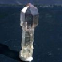
I am a new member of mindat.org and was just out in the Cahuilla Mountains to dig for tourmalines at a pegmatite. The schorl crystals are in a fine grained quartz matrix and can become quite large (up to 10”). However, there are no pockets and it needs some luck to get them out without too much damage. Most of them disintegrate while trying it. I found my best schorl after a lot of work on last Sunday and it measures just about 2.7” (attachment: tourmaline). So far, I didn’t hope to find any pockets there, since the pegmatite is very dense, consists mainly of quartz and schorl and has only a bit mica and no garnets, beryl, etc.
But on Sunday, I found some quite large feldspar crystals at two places (attachment:2) and I am wondering, if they could be a sign for a pocket zone… My main concern is that I haven’t found any quartz crystals or a perthite structure yet.
Does anybody have some experience with pockets in this region? Should I start to dig further at the spot where I found the feldspar or are such crystals quite common and ar not necessarily connected with pockets?
Thanks a lot for any helpful comments
Patrick
12th Oct 2011 00:19 UTCMickey Marks
12th Oct 2011 05:35 UTCPatrick Staeheli
However, no need to envy me. You are obviously close to ome very nice smoky quartz and amethyst crystalls, as I could see on your home page - nice finds.

16th Oct 2011 12:07 UTCScott L. Ritchie Expert
Based on my experience in the area, if you're not finding euhedral quartz crystals, you're not going to find much otherwise, and those subhedral microclines are very common for the Cahuilla District, which can occur up to several feet across. If you tell me what general area you're prospecting, I may be able to guide you to a more productive location in the district to invest your sweat equity.
Scott
17th Oct 2011 21:10 UTCAnonymous User
...follow the "roadsigns" in many cases the schorl tourmaline are sign post pointing the direction of the highest mineralization. Follow the direction the schorl crystals are pointing. This is a generality and won't apply to all pegs since each is it's own beast but many times the schorl will point towards the areas of higher mineralization. The increasing grain size you are seeing in the larger feldspar crystals is a good sign. Also check for fractures that originate towards the same area or point. Check to see if the fractures have small crystals in them loose or lined. Look for odd bends and attitude changes in the shape of the peg. Any strong upwards trend or downward dips(offsets) indicate a VERY good place for a pocket. Check to see if the country rock drops down into a portion of the peg that is not consistant with the rest of the overall shape. As an example this is a classic example of what happens at Mt. Mica. The best pockets are found where the peg pinches or dips hard in the country rock. Look for spongy otr textural differences in the material. Thats a good indicator. There are a couple other good things but these will help for now
18th Oct 2011 00:04 UTCPatrick Staeheli
Thanks a lot for the good information. I have just been out again - mainly to dig and get a better overview and to "finish" the site. I could again get some good schorl crystals but have to agree with Scott: the feldspars are here obviously not a sign for pockets. They were like the tourmalines just surrounded by massive quartz. Also, the mineralization was more towards the walls of the pegmatite, whereas the middle part consisted only of massive quartz. However, I am quite pleased with the schorls (I posted one picture on my mindat homepage).
I will keep the "road signs" in my mind for my further field trips and post any success. Well, where would you suggest going then, Scott? So far the Cahuilla Mountains were my favorite spot. I found once a small quartz pocket close to the place where the andalusites are - but nothing really exciting. However, I was also thinking about visiting the area around Little Cahuilla Mountain.
18th Oct 2011 02:36 UTCJim Bean 🌟
18th Oct 2011 03:35 UTCAnonymous User
Keep us up-to-date on your findings and travels.. That schorl are great!
18th Oct 2011 08:38 UTCScott L. Ritchie Expert
Check out the locality page on mindat for the Sly Rick prospect (Green Centipede claim) Sly Rick prospect (Green Centipede claim) http://www.mindat.org/loc-122355.html. Also, see my old posts in the forums, which cover directions, etc.
http://www.mindat.org/forum.php?read,15,206960,207004#msg-207004
http://www.mindat.org/forum.php?read,5,213369,213421#msg-213421
Good luck out there.
Scott
19th Oct 2011 19:20 UTCPatrick Staeheli
Jason, I didn’t have much good pictures of the schorl pegmatite, since it was just very dirty and mostly covered with soil. But I posted a few pictures from another pegmatite, where I found a small quartz pocket. Perhaps I should spend there also another day or two..
Patrick
20th Oct 2011 04:14 UTCbrian magni
20th Oct 2011 08:55 UTCScott L. Ritchie Expert
The Bureau of Land Management and Forest Service have posted the Juan Diego mine area to prevent mineral trespass. Since 2006, visitors to the site have been warned via official signs that any unauthorized removal of mineral materials is prohibited.
http://www.mindat.org/photos/0918301001162403437.jpg
Also avoid the Lithia Dike mine, the Audrey Lynn mine, Brian Ward claim, and the Fano mine area, as these are all privately owned. There may be new active claims in the area, so always keep an eye out for monuments, signs, tools and fresh disturbances, and avoid those areas completely. The Sly Rick prospect is likely your best bet, it just requires some strenuous hiking and a little good luck. It's totally worth the effort based on my experience.
Scott
21st Oct 2011 16:33 UTCPatrick Staeheli
If you did already some research on pegmatites, you most likely know the most important facts already. If you keep this knowledge in mind and expand it, e.g. with the "road signs" mentioned from Jason further above you are on a good way.
Now, the trouble is, that in reality things are often more complicated. To make a decision if it is worth to start digging, needs a lot of outdoor experience - and most often one is still at the wrong place.
Basically, any irregularity in the rock or vein is a first good sign, e.g. bulges, unusual big crystals, leached areas, ... Additionally, if you find any mineralized zones with euhedral crystals, you can assume that you are getting closer. And - as Scott mentioned it above - in the Cahuilla Mts. you should find euhedral quartz crystals.
However, I will contact you when I go out for my next trip (perhaps late Nov?).
Good luck until then
Patrick
22nd Oct 2011 01:30 UTCbrian magni
Brian.
23rd Oct 2011 00:29 UTCLawrence Dee
23rd Oct 2011 14:41 UTCScott L. Ritchie Expert
The Juan Diego mine http://www.mindat.org/loc-87062.html is on acquired private lands, and all of the hardrock mineral materials on this property are subject to prospecting and leasing via preference rights, which fall under a different set of public land laws than those that address mining claims. The signage for the site has nothing to do with locatable minerals because the land is withdrawn from mineral entry under the general mining laws.
A prospecting permit has already been issued and a lease application has been pending for well over a decade. The mineral estate is managed by the U.S. Department of the Interior, Bureau of Land Management (BLM), and Minerals Management Service (MMS). Surface resources are managed by the U.S. Department of Agriculture, Forest Service.
Mineral trespass at this particular site includes any non-permitted removal of the mineral estate. Call the phone number on the sign if you have any additional questions.
Scott
25th May 2012 01:33 UTCLawrence Dee


Mindat.org is an outreach project of the Hudson Institute of Mineralogy, a 501(c)(3) not-for-profit organization.
Copyright © mindat.org and the Hudson Institute of Mineralogy 1993-2024, except where stated. Most political location boundaries are © OpenStreetMap contributors. Mindat.org relies on the contributions of thousands of members and supporters. Founded in 2000 by Jolyon Ralph.
Privacy Policy - Terms & Conditions - Contact Us / DMCA issues - Report a bug/vulnerability Current server date and time: April 26, 2024 19:19:58