Natrophilite from
Fillow Quarry (Branchville Quarry; Branchville Mica Mine; Smith Mine), Branchville, Redding (Reading), Fairfield County, Connecticut, USA


| Locality type: | Quarry | |
| Classification | ||
|---|---|---|
| Species: | Natrophilite | |
| Formula: | NaMn2+PO4 | |
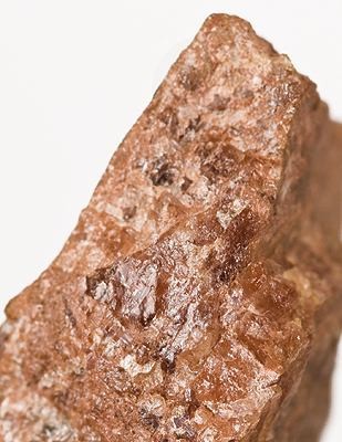
| Comments: | Small regions within lithiophilite nodules. Description of type material from Brush and Dana (1890): "The luster is brilliant resinous to nearly adamantine; it was, in fact, the brilliancy of the luster which first attracted our attention, and which is, so far as the eye is concerned, its most distinguishing character. The mineral itself is perfectly clear and transparent, but the masses are much fractured and rifted. The surfaces are often covered by a very thin scale of an undetermined mineral, having a fine fibrous form, a delicate yellowish color and silky luster. This same mineral penetrates the masses wherever there is a fracture surface of cleavage or otherwise. What the exact nature of this mineral is we are unable to say, since the amount is too small to admit of a satisfactory determination - it appears to be a manganesian phosphate. It is evidently an alteration-product and would seem to imply that natrophilite is rather subject to easy chemical change. In any case this silky film is one of the characteristic features of the mineral, and directs attention to it at once even over the surface of a hand specimen where it is associated with lithiophilite and perhaps three or four other of these phosphates." | |
| Habit: | massive, local alterations within lithiophilite | |
| Colour: | deep, wine-yellow | |
| Abundance at site: | Very Rare | |
| Confirmation | ||
| Validity: | Valid - Type Locality | |
| Associated Minerals: | ||
| Associates: | Dickinsonite-(KMnNa) Eosphorite Fairfieldite Hureaulite Lithiophilite Triploidite | |
| Associated Minerals Based on Photo Data: | ||
| Lithiophilite | ⓘ7 photos of Natrophilite associated with Lithiophilite at this locality. | |
| Triploidite | ⓘ5 photos of Natrophilite associated with Triploidite at this locality. | |
| Purpurite | ⓘ5 photos of Natrophilite associated with Purpurite at this locality. | |
| Cleavelandite | ⓘ5 photos of Natrophilite associated with Cleavelandite at this locality. | |
| Eosphorite | ⓘ1 photo of Natrophilite associated with Eosphorite at this locality. | |
| Data | ||
| Mineral Data: | Click here to view Natrophilite data | |
| Locality Data: | Click here to view Fillow Quarry (Branchville Quarry; Branchville Mica Mine; Smith Mine), Branchville, Redding (Reading), Fairfield County, Connecticut, USA | |
| Photo Gallery | View Gallery (4 photos) | |
| Data Identifiers | ||
| Mindat Occurrence Record ID: | 97375 | |
| Long-form Identifier: | 1:3:97375:1 | |
| GUID (UUID V4): | 4aaa5c42-6778-42b4-b503-9b7df26a5d2c | |
| Nearest other occurrences of Natrophilite | ||
| 79.3km (49.3 miles) | ⓘStrickland Quarry, Strickland pegmatite, Collins Hill, Portland, Middlesex County, Connecticut, USA | |
| References | ||


Fillow Quarry, Branchville, Redding, Fairfield County, Connecticut, USA