| Classification |
|---|
|
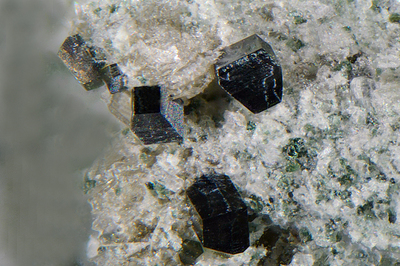
| Species: | Anatase |
| Formula: | TiO2 |
| Confirmation |
|---|
|
| Validity: | Believed Valid |
| Associated Minerals Based on Photo Data: |
|---|
|
| Hematite | ⓘ1 photo of Anatase associated with Hematite at this locality. |
| Monazite | ⓘ1 photo of Anatase associated with Monazite at this locality. |
| Data |
|---|
|
| Mineral Data: | Click here to view Anatase data |
| Locality Data: | Click here to view Anger valley duct, SAFE Power station, Remsach, Bad Gastein, St. Johann im Pongau District, Salzburg, Austria |
| Photo Gallery | View Gallery (4 photos) |
| Data Identifiers |
|---|
|
| Mindat Occurrence Record ID: | 891954 |
| Long-form Identifier: | 1:3:891954:0 |
| GUID (UUID V4): | b56ed0ce-b572-4206-ae97-d0fb6c2379e2 |
| Nearest other occurrences of Anatase |
|---|
|
|
| 1.5km (0.9 miles) | ⓘVorderschneeberg, Anger valley, Bad Hofgastein, St. Johann im Pongau District, Salzburg, Austria |
| 5.4km (3.4 miles) | ⓘAnderl cleft, Stuhlwald, Böckstein, Bad Gastein, St. Johann im Pongau District, Salzburg, Austria |
| 5.4km (3.4 miles) | ⓘStuhlwald, Böckstein, Bad Gastein, St. Johann im Pongau District, Salzburg, Austria |
| 5.6km (3.5 miles) | ⓘRiepler building, Böckstein, Bad Gastein, St. Johann im Pongau District, Salzburg, Austria |
| 5.7km (3.5 miles) | ⓘBöckstein, Bad Gastein, St. Johann im Pongau District, Salzburg, Austria |
| 5.9km (3.7 miles) | ⓘMunicipal quarry (Dick quarry), Böckstein, Bad Gastein, St. Johann im Pongau District, Salzburg, Austria |
| 6.2km (3.9 miles) | ⓘGewerkenwald, Naßfeld valley, Bad Gastein, St. Johann im Pongau District, Salzburg, Austria |
| 6.4km (4.0 miles) | ⓘEvianwand, Böckstein, Bad Gastein, St. Johann im Pongau District, Salzburg, Austria |
| 6.9km (4.3 miles) | ⓘOrtbergschartl, Naßfeld valley, Bad Gastein, St. Johann im Pongau District, Salzburg, Austria |
| 9.4km (5.9 miles) | ⓘSchleierfall tunnel, Naßfeld valley, Bad Gastein, St. Johann im Pongau District, Salzburg, Austria |
| References |
|---|
|
|


Anger valley duct, SAFE Power station, Remsach, Bad Gastein, St. Johann im Pongau District, Salzburg, Austria