 | | Report (volume) | | Lower Part of the Green River Formation, Piceance Creek Basin, Colorado GEOLOGICAL SURVEY BULLETIN 1529-1...Lower Part of the Green River Formation, Piceance Creek Basin, Colorado By RONALD C. JOHNSON CONTRIBUTIONS...lacustrine unit is assigned a new name, and the Douglas Creek Member is redefined. New names are also assigned...Formation UNITED STATES GOVERNMENT PRINTING OFFICE, WASHINGTON : 1984 UNITED STATES DEPARTMENT OF THE INTERIOR...lower part of the Green River Formation, Piceance Creek Basin, Colorado. (Contributions to stratigraphy)(Geological |  | | Book | | Paleolimnology of the Green River Formation, Western USA Syntheses in Limnogeology Volume 1 Series Editors...Engineering, University of Nevada, Reno, Nevada, USA Elizabeth Gierlowski-Kordesch Department of Geological...Geological Sciences, Ohio University, Athens, Ohio, USA Aims and Scope The aim of this book series is to...Paleolimnology of the Green River Formation, Western USA Editors Michael Elliot Smith School of Earth Science...AZ, USA Alan R. Carroll Department of Geoscience University of Wisconsin-Madison Madison, WI, USA Additional |  | | Journal (article/letter/editorial) | | (about 19131, Esterbrook copper district, Albany County. John Taylor collection. An ideal and inexpensive...“The Copper Mountain Pegmatite District, Freniont County, Wyoming” and was in the JulylAugust 2001 issue...most notable ones. The localities are listed by county and then in alphabeticnl order. Where numerous...names are from Hausel (1986). Localities by County Albany County Allanite pegmatite, 12 miles W of Bosler...s, ColoradoWyoming State Line district, Albany County: largest crystal is approximately 0.Y carat. Karl |  | | Report (chapter) | | Uinta Basin’s Eocene Green River Formation in Utah, USA THOMAS C. CHIDSEY JR1*, MICHAEL D. VANDEN BERG1 &...84114-6100, USA 2 Eby Petrography & Consulting Inc., 2830 West 9th Ave, Denver, CO 80204, USA *Corresponding...interparticle and intraparticle porosity. West Willow Creek oil field produces from a Green River microbial...Formation Skyline 16 research core and West Willow Creek oil field core (a productive microbial carbonate...large lakes in the Great Basin region of the western USA formed during glacial maxima; the Wasatch Range and |  | | Report (issue) | | use for it write to the Geological Survey at Washington and ask for a frank to return it UNITED STATES...PRINTING OFFICE WASHINGTON : 1936 For sale by the Superintendent of Documents, Washington, D. C. ------....__-_-_ 33. Plan and section along tunnel of Washington Phosphate & Silver Co., Maxville, Mont_-_______________...195-228, 1917; Phosphate rock near Maxville, Granite County, Mont.: U. S. Geol. Survey Bull. 715, pp. 141-145...its successor, William Anderson, on East Brock Creek near Garrison, in an area described in Bulletin |  | Campbell, J.R., Craw, D., Frew, R., Horton, T., Chamberlain, C.P. (2004) Geochemical signature of orogenic hydrothermal activity in an active tectonic intersection zone, Alpine Fault, New Zealand. Mineralium Deposita, 39 (4) doi:10.1007/s00126-004-0421-4 | Journal (article/letter/editorial) | | have been cemented by calcite, illite, smectite and chamosite. Ankerite and calcite have d18O between +10...Sciences, Stanford University, Stanford, CA 94305-2115, USA Keywords Hydrothermal Æ Gold Æ Arsenic Æ Alteration...et al. 2002). Minor hydrothermal alteration and calcite deposition has occurred near to the Alpine Fault...rare chalcopyrite as well as gold. Late-stage calcite veins within this swarm are enriched in arsenic...rocks in the Alpine Fault zone, Big Wainihinihi Creek. A Highly fractured mylonite (dark) is cut by three |  | | Report (issue) | | Member R7 Garden Gulch Member R7 Douglas Creek Member R8 Parachute Creek Member R8 Lithologic terms: marlstone...intertongued sequence R13 Uinta unit A R13 Coughs Creek Tongue of the Green River Formation R13 Uinta unit...deposits R18 Structure R18 Crystal Creek anticlinal nose and Clear Creek syncline R19 Faults R19 Economic...Location of central Roan Plateau area, Piceance Creek basin R2 2. Generalized geology of central Roan...km2) in the south-central part of the Piceance Creek basin in northwestern Colorado, about 20 mi (32 |  | | Report (issue) | | Colorado UNITED STATES GOVERNMENT PRINTING OFFICE, WASHINGTON : 1967 . , UNITED STATES DEPARTMENT OF THE...of Documents, U.S. Government Printing Office Washington, D.C. 20402 CONTENTS Abstract ____________...Green River Formation _____________________ _ Douglas Creek Member ________________ _ Garden Gulch Member..._________________ _ Parachute Creek Member _______________ _ Evacuation Creek Member ______________ _ Tuff...along Hill Creek _______ ---- ___ -_---_---------5. Tuffaceous dikes in the Parachute Creek and Evacuation |  | | Report (issue) | | . . . . . . . . . . . . . . . • .. 37 Goose Creek area . . . . _ __ . . . _ .. . _ __ . _ . _ . ....descriptions . . . . .. . . . . . . . . . . . . Kelly Creek area . . . . . . . . . . . . . . . . . . . . . ... . . . . . . . . . . • • . . . . . . 52 Mush Creek oil field . . . . . . .... . ... . ... . ... . ••... . . . . . . . . 57 Tin Cup (Black Rock-Long Creek) district . . . . • • . . • • • • • . . . . . ..... . . . . . . . . . . Washakie Basin (Founnile Creek placers) Hartville uplift . . . . . . . . . . . |  | | Report (issue) | | Geology and Oil-Shale Resources of the Piceance Creek Basin Between the Colorado and White Rivers Northwestern...1082-L UNITED STATES GOVERNMENT PRINTING OFFICE, WASHINGTON : 1961 UNITED STATES DEPARTMENT OF THE INTERIOR...of Documents, U.S. Government Printing Office Washington 25, D.C. CONTENTS Abstract___-_-----.__--.-_-...series_--___-_-_-_-_-_-_-_-_-_______.________ Ohio Creek conglomerate.______________________________ Paleocene...formation .............................iL.. 847 Douglas Creek member______________________!____ Garden Gulch |  | | Report (issue) | | THE DUNKLEBERG MINING DISTRICT, GRANITE COUNTY, MONTANA/ By J. T. PARDEE. LOCATION. The Dunkleberg district...district is in northeastern Granite County, Mont., about 50 miles northwest of Butte. (See fig. 16.)...and 5 miles long, near the north end of the Flint Creek Eange. From Hall, a town on the Philipsburg branch...formerly used for hauling ore, that goes up Dunkleberg Creek from Jens, a station on the Northern Pacific main...which is in the northern foothills of the Flint Creek Range, has a rather uniform general slope toward |  | | Report (issue) | | Colorado Piceance Creek Watershed. 2. Gas, Natural Geology Colorado Piceance Creek Watershed. I. Title...of the Mesaverde Formation and equivalent Trout Creek Sandstone Member of the lies Formation E4 4. Generalized...calculated for Corcoran, Cozzette, and Rollins or Trout Creek Members E33 15. Total calculated volume of methane...the west by the Douglas Creek arch. At times during the early Cenozoic, the Douglas Creek arch divided the...dome and forms the northern terminus of the Douglas Creek arch. The Rangely anticline is the only giant |  | | Report (issue) | | of the Parachute Creek Member, Green River Formation, in the Northern Piceance Creek Basin, Colorado GEOLOGICAL...of the Parachute Creek Member, Green River Formation, in the Northern Piceance Creek Basin, Colorado By...sections UNITED STATES GOVERNMENT PRINTING OFFICE, WASHINGTON : 1973 UNITED STATES DEPARTMENT OF THE INTERIOR... CONTENTS Page ADstract Introduction -----Piceance Creek basin -----Lithologic terms - ----- ----- ----------Tertiary...Formation Douglas Creek Member -Garden Gulch Member ~ Anvil Points Member Parachute Creek Member Evacuation |  | | Report (issue) | | For nle by the Superiatendent of DoeuJ~W~Bta. Washington. D. C. - • • • • Prlee 60 el!nts CONTENTS..... _____ _ Rocks east of Bitter Creek, Utah _______ _ Douglas Creek member ____________ _ Garden Gulch...member _______ -----Parachute Creek member __________ _ Evacuation Creek member _________ _ Delta and...______________ _ Rocks west of Bitter Creek, Utah _______ _ Duchesne-Uintah county line section ___________________________...Correlation of facies and zones in Uinta and Piceance Creek Basins ___________________ _ Bridger formation ________ |  | | Report (issue) | | Arch aeology of Southern Blue Mountain and Douglas Creek, i\orthwestern Colorado by Gilbert R. Wenger...in the field work on the Turner Ranch in Grand County, Utah, which is described here; to Al Look, who...studied the geology of the Taylor Site in Mesa County, Colorado. Data obtained through personal communications...otherwise were obtained through the kindness of F. H. Douglas who put his excellent library at my disposal. Sherd...................................... . 99 Kanab Creek ............................................... |  | | Report (issue) | | quality UNITED STATES GOVERNMENT PRINTING OFFICE, WASHINGTON : 1981 UNITED STATES DEPARTMENT OF THE INTERIOR...aspects Colorado Piceance Creek watershed. 2. Hydrology ColoradoPiceance Creek watershed. 3. Geochemistry...Geochemistry Colorado Piceance Creek watershed. I. Saulnier, George J., joint author. II. United States Environmental...of Documents, U.S. Government Printing Office Washington, D.C. 20402 CONTENTS Page Page Conversion......... 7. Saturated thickness of the Parachute Creek Member above the Mahogany zone ................ |  | | Report (issue) | | Geology of the Lower Yellow Creek Area, Northwestern Colorado U.S. GEOLOGICAL SURVEY BULLETIN 1787-O...Superintendent of Documents Government Printing Office Washington, D.C. 20402 (Check or money order must be payable...authorized agents of the Superintendent of Documents: WASHINGTON, D.C.-Main Interior Bldg., 2600 corridor, 18th...California-Customhouse, Rm. 504,555 Battery St. SPOKANE, Washington-U.S. Courthouse, Rm. 678, West 920 Riverside...Twelfth Ave. Chapter O Geology of the Lower Yellow Creek Area, Northwestern Colorado By WILLIAM J. HAIL, |  | | Report (issue) | | report on solid bitumens in Eocene rocks of Piceance Creek basin, northwestern Colorado By R. B. O 1 Sullivan............................ BITUMENS IN PICEANCE CREEK BASIN................................... SUBSURFACE........................... Index map of Piceance Creek basin....................... Infrared spectra of...properties of samples of bitumen from Piceance Creek basin................. 9 INTRODUCTION Solid hydrocarbons...hydrocarbons are also found at localities in the Piceance Creek basin but all are unimportant and of small extent |  | | Report (volume) | | study UNITED STATES GOVERNMENT PRINTING OFFICE, WASHINGTON : 1994 U.S. DEPARTMENT OF THE INTERIOR BRUCE...Cretaceous succession, so only the Jens and Carten Creek Formation are present. Tertiary and Quaternary sedimentary...as the Blackfoot City, Illinois Ridge, and Marsh Creek faults appear to have offset rocks during Late Cretaceous...Mountains J LM John Long Mountains FV FCR Flint Creek Range DLV Deer Lodge Valley BM Boulder Mountains...Gwinn (1961) fro~ the northwest part of the Flint Creek Range (fig. I), whereas rocks in the parautochthonous |  | | Report (issue) | | known. For simplification by AGI the Sections on County Index and Rock Unit Index were merged into a broader...bibliography can be searched by location, i.e. the county or by the subject material or the rock unit name...01491423, CODEN: AABUD2. American Mineralogist. Washington, DC: Mineralogical Society of America, 1916-...ISSN: 07319789. Analytical Chemistry (Washington, DC). Washington, DC: American Chemical Society. 1948-...American Chemical Society, National Meeting. Washington, DC: American Chemical Society, 1937-. ISSN: |  | | Report (issue) | | tables UNITED STATES GOVERNMENT PRINTING OFFICE, WASHINGTON : 1973 UNITED STATES DEPARTMENT OF THE INTERIOR...of Documents, U.S. Government Printing Office Washington, D.G. 20402 Stock Number 2401-2201 CONTENTS...district_____________________ Gird Creek syncline__-__-_______-_-_________ Douglas Creek syncline.---____-_-____--__-__...Coberly syncline.__-______________-_________ Gold Creek syncline________________________ Pendant syncli...Measured section of Permian rocks near Little Gold Creek, south of Moonlight mine, Montana.____--____ 5-8 |  | | Report (issue) | | ... 15 7. Saturated thickness of the Parachute Creek Member above the Mahogany zone. .................... 19 11. Saturated thickness of the Parachute Creek Member below the base of the R-6 zone ............discharge and dissolved-solids concentrations in Yellow Creek valley produced by pumping mine near tract C-a at...and dissolved-solids concentrations in Piceance Creek valley produced by pumping mine in tract C-b at...concentrations in ground-water discharge to Piceance Creek valley produced after 60 years of leaching from |  | | Journal (article/letter/editorial) | | 94305, USA Geological and Environmental Sciences, Stanford University, Stanford, CA 94305, USA Department...Geophysics, University of Wisconsin, Madison, WI 53706, USA a r t i c l e i n f o Article history: Received...entering Lake Uinta from the east via the Piceance Creek Basin of northwestern Colorado. This large new source...evaporation in the Greater Green River and Piceance Creek Basins meant that the waters entering Lake Uinta...overtopped the Douglas Creek Arch (DCA) at its eastern end to merge with the lake in the Piceance Creek Basin |  | | Report (issue) | | recovery) tests using test holes completed in the Douglas Creek aquifer ..... Lithologic log of test hole 1...Mahogany zone, an oil-shale bed in the Parachute Creek Member of the Green River Formation. A water sample...concentration of 9,870 milligrams per liter. The Douglas Creek Member of the Green River Formation is a major...Values of transmissivity calculated for the Douglas Creek aquifer from hydrologic tests ranged from 16...importance, has been divided into three members—the Douglas Creek, Garden 1 A1though the basic land unit, the |  | | Report (issue) | | the Cross Mountain Wilderness Study Area, Moffat County, Colorado U.S. GEOLOGICAL SURVEY BULLETIN 1759-A...Superintendent of Documents Government Printing Office Washington, D.C. 20402 (Check or money order must be payable...authorized agents of the Superintendent of Documents: WASHINGTON, D.C.-Main Interior Bldg., 2600 corridor, 18th...California-Customhouse, Rm. 504,555 Battery St. SPOKANE, Washington-U.S. Courthouse, Rm. 678, West 920 Riverside...the Cross Mountain Wilderness Study Area, Moffat County, Colorado By KARL V. EVANS, JAMES G. FRISKEN, and |
|

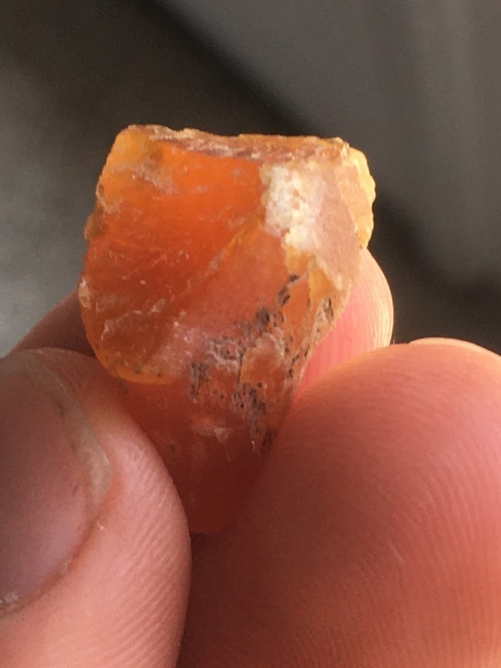


Douglas Creek, Douglas County, Washington, USA