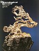
 | | Journal (issue) | | from the C en ten n ia l Eureka m in e, T intic district, Juab C ounty, U ta h ..........................Richard also became charter members o f the Tualatin Valley Gem Club and the Friends of Mineralogy. Over the...surrounding valleys. To the west lies the Sacramento Valley, which drains southwest to the Colorado The Mineralogical...River near Needles. To the east is the Hualapai Valley, which drains north into the Red Lake Playa. The...end o f the Wallapai Mining District. The major mining centers of the district included Cerbat, Chloride | 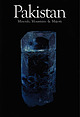 | | Report (issue) | | To Our Readers: Pakistan is a mineralogically-rich and interesting country. The quantity of Pakistani...us by surprise when people began to ask, "Why Pakistan; why now?" It has never been our intention to...the mineral deposits of the high mountains of Pakistan and Afghanistan. Once into the project, however...justice to neither. We decided to limit our focus to Pakistan, though even focused on a single country, a comprehensive...aquamarine); 19.6 cm high Shigar Valley, Skardu district, Northern Areas, Pakistan P hoto by Jeff Scovil | 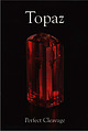 | | Report (issue) | | (weighing a total of 2.52 carats) from Katlang, Pakistan, adorn the upper wings, with a matched pair of...ZBYNEK BURIVAL 46. On the Topaz Trail in Gilgit-Baltistan DUDLEY BLAUWET 58. Zimbabwe Blue Topaz: St...the term "topaz" in reference to the olivines, quartz, and other Topaz crystals can be extraordinarily...Moreover, gold-color quartz ("citrine") is often labeled "topaz quartz" and brown, smoky quartz is sold as "smoky...schorl, and albite, 7.8 cm tall; Shigar Valley Gilgit-Baltistan, Pakistan; Wayne Sorensen collection, Scovil | 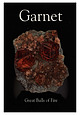 | | Report (issue) | | Spessartine from Tongbei BY BERTOLD OTTENS 70 Pakistan and Afghanistan: Garnet from the Roof of the World...uranium-vanadium deposit of the Sandy Mine in the Laguna District, New Mexico, is the type locality for goldmanite...of the Kao Kimberlite Pipe in the Butha-Buthe district of the landlocked African Kingdom of Lesotho....lazurite ("lapis lazuli"), and various varieties of quartz were generally used for seals in Mesopotamia. Important...Chosroes II" inlaid with large relief-cut garnet, quartz, and green glass (Bibliotheque National de France |  | | Journal (issue) | | were combined under the jurisdiction of the U.S. District Court of New Jersey 168 PRODUCTION AND MARKETS...militant Taliban were forcing residents of the Swat Valley, which had been closed for nearly a decade, to...finance terrorist activities (“Emeralds from Swat Valley. . . ,” 2009). The decade also saw the rise in...to the traditional spinel sources of Sri Lanka, Pakistan, and Myanmar (spinel, if polished elsewhere, is...start operations at the Kagem mine in the Kafubu District, historically Zambia’s largest source of emeralds |  | | Book | | Litchfield County, where good crystals were taken from quartz veins in a variety of metamorphic, plutonic and...Litchfield, where a mass of white quartz on a ridge had once been mined for quartz, and large ilmenite masses...ilmenite crystals to 7 .5 cm in matrix of massive quartz from these dumps-adding that, in his judgment,...Mount Malosa, Chilwa alkaline province, Zomba district. "Illite" is the name of a series of incompletely...major associations of Swiss hematite iron roses are quartz, ortboclase, albite, rutile, and zeolites (especially |  | | Report (volume) | | (Smithsonite ai Blende) with Barytes én theKarnul District, Madres.—By F. B. Matzer, F.G.8., Geological Survey...from the neighbourhood of Juggiapett, Kistnah District, and on Zinc Carbonate from Karnul, Madras.—By...Kaghén glacier can have travelled down the steep valley of the Kanhar without removing or disturbing the...and those of the Hindu Kush on the west. North of Shigar an independent basin of triassic and palwozoic...7th of Decombor, and resumed work in the Madara district ;Mr. Wynnc took twenty months’ leavo on the 3rd |  | | Journal (article/letter/editorial) | | showed hrgc incrcnscs coinparctl with 1922. Imports folJo\\~xl tlic S ~ I U Cgeneral trcnd, oniounting t o...cllemical proccsscs. The v;iluc rcportcd for crudc quartz in 1923 ranged froin $1.52 to SS a ton and nvcragcd...estimated that the slinlc clcposits in tilo Lutrolw district contniiicd 10 million tons, with probablc rc.scr\-w...RIcNurrny, Alberta, upon tlic tiir-sands of tliut district. Tho coinpiiiiy will crcct 0110 unit of the Gcorgcson...Platinum Compuny’s proportics in tho Watcrbcrg district, a company, cntitled Tho Dominion Platinum CorponLtion |  | | Report (issue) | | reconln1er1ded that refercnc:e t<> this work be made in the folJo,,,_·ing form: Davies, A. 1972. i\ descriptio11 of...comrno11 pebbles s,inclstone arid ir1{:!11de veirr quartz, c:hert, lava. Fai11t!y, calc,1reous p,1tc:l1es...or1glc)Ill<'r,11e \\'itl1 {JelllJ!es of ,,;l1ite quartz arid sc,1ttt·rc:cl c cJl>blt·s, UJ) 1.0 9 1 mn1...muclstor1es and silt St()Iles. Sanclsto11e v. i tl1 quartz pebl>les occurs i n ler1ses lIJJ to I m thic:k...t<> st1b rour1cled a11d co11sist 111,1i11 l y of quartz, ciuartzite, and gre)',vackt•. Tl1e l)ells ,tr(: |  | | Journal (issue) | | cognac-brown, water-clear topaz crystals with milky quartz crystals and large, white feldspar crystals. INTRODUCTION...crystal after crystal. Beautiful groups of milky quartz crystals to 15 cm and large, white feldspar crystals...transparent crystals which differed plainly from the quartz crystals, even while still in the pocket clay;...color and the ability of these crystals to scratch quartz (hardness 5 7) confirmed the identification as...topaz crystals were found still attached to milky quartz crystals. The largest crystal measures 8.8 cm in |  | | Journal (issue) | | 1ncr<-nsing soft alloy extrusion prices 2, a lb. Th is folJo,vl'd Ohn's move announced l\\'o \veeks earlier....Sl ............ $86.50 Brass and Bronze Ingot QUARTZ ROCK CRYSTAI.S: For fusing, all sJzes, st. . ....Bettman Arch111e, Inc., rrom " Exploration of the Valley of the Amazon," published in 1854 under sponsorship |  | | Report (issue) | | of Towe1-- Hill, M1--. Heath of tl1e Biddt1lpl1 Valley Ironworks, Mr. Goslin, Mr. Cooper, and M1". Bateman...the Gold sitcl1 Coal-field ; (f) the Mee1·brook Valley ; (g) Gun Hill ; (It) Yoredalc Rocks on the cast...Combs ifoss ; ( o) Pebble Beus of t110 Cl1t11·net Valley. (II.) Country b t,veon tl1e A11ticli11nl tlnd...AND PHYSICAL FEATURES OF TRE COUNTRY• .. THE district to be dcsc1·ibed in the present Memoi1� is about...IJlays so leading a part i n the geology of the district, we sl1all at once 111arlc ot1t its line n11d |  | | Report (issue) | | of the Cretaceous stratigraphy of the Arkansas· Valley were begun by G. K. Gilbert in 1893 with the mapping...reconnaissance of the more easterly portion of the valley led to the publication in 1896 of ·Gilbert's report...report on. the underground water of the Arkansas Valley in .I eastern Colorado. 3 The description of the...water of the Arkansas Valley was published. With the appearance of the Castle Rock foljo 7 in 1915 and the...detailed .repo:cts on itreas .in the Ar~ kansas Valley in Colorado ha 've since app.eared," and 106" FIGURE |  | | Book | | of Nerbudda District.-Tertiary and alluvial deposits of central portion of Nerbudda Valley.-Geological...of Trichinopoly District, Madras. Pt. 2, 1864 (out of print) (price 2 Re.) : District of Trichinopoly...(price 2 Re. 10 AE.) : C o a e l Region of GodBvari District. Pt. 1, 1879 (price 3 Rs.) : Geology of Western...Rep. 1930 (price 3 Rs. 14 As.) : Pranhita-Go&vari Valley. Pt. 1, 1882 (price 2 Rs.) : Cachar Earthquake...(out of print) (price 6 Rs.) : Geology of BeUary District, Madrae Presidency . 1896 ( a t of print) (price |  | | Report (edition) | | have not moved sensibly since the'. Susquehanna Valley b.as been inhabited by ,vhite men it could not...satisfactory reply and explanation from H. R. Moffitt, district engineer, Pennsylvania Department of Highways...s1nall cave. It is in the east bank of Snake Spring Valley R u11, just above a :,;pring 100 ;rards north of...be flooded because the strea1n in the adjacent valley is ,vell belo,v the lowest part of the caverns...glistens ,:vith water. Far within the cave thin quartz veins project nearly an inch from the ,vall and |  | | Report (edition) | | town, constitt1tes the most important mineral district in North Staffordshire, and is at the same time...poi11t is not so conspicuous, ancl in the b1·oad valley between Madeley Road Station and Whitmore Station...w-\rtr;Ar appear fron1 beneath it in the Craven district. But it is not improbable t.h at Arch9?an rocks...GENERALISED SECTION ACROSS ENDON (G. BARROW). Endon Valley D. Alluvial Deposits. C. Bunter of Endon Hill...Stanley Grit is probably the Fifth Grit of the Da11e valley in the map to the no1·tl1 (shee·t 110). The beds |  | | Report (issue) | | the description of the mineral resources of that district. .Accordingly the subject has been divided into...worth of ore, and it 'seems probable that the district is by no ineans exhausted, but that, if trade...the lodes traversing the northern parts of the district. was included in two of the Geological Survey...The area south of Llana.rmon falls withip. the district recently revised on the six-inch maps by Messrs...Maes-y-safn Lode ... ,, 14.-Map of the 1,finera Mining District .. . ,, 15.-Sections of Taylor's, Roy's, and the |  | | Report (edition) | | �Iomoi1·s of tho GcologicuJ � 11r,10.r. It ,,l'as folJo,,r cf-1\\1 ft1rtl1 'l" rosea1·ol1es on tl10 samo...- 70 Glacial .Deposits :- (1) Tlie .Ajon Lwyd Valley : (2) The Ebbw and Sir howy Valleys : (3) The...The Rhymney and Aber Valleys : (4) The TaJf Valley. Post-Glacial JJeposits .·-.Rivet� Gravels ( Ter;-races)...Comparative Sections of the Coal �ieasl1res in the Taff Valley ancl near Pontypool - 31 Comparati,Te Sections...Rhym ney and Fochrhiw, and receives also the Aber Valley. At Walnut Tree the Taff, which, with its tributaries |  | | Book (volume) | | continuation in the same direction north of the Son Valley, known as the Kaimur Range, are merely the southern...intercalated traps. He chose the name " Dharwar" from the district (no,v- in 1\1:ysore State) in which he first recognized...were supposed to represent crushed vein quartz, felsite, or quartz porphyry ; the limestones were considered...some of the quartzites occurring in the Tumkur district. B. JAYARAl\i succeeded W. F. SMEE1'H as Director...origin, associated with thin bands of quartz schists, ferruginous quartz rocks, and calcium pyroxene granulites |  | | Book | | of lacustrine sediments filled the pre-existing valley. At the end of the Pleistocene the present channel...located in central Missouri overlooking a large river valley carved by the Pomme de T erre River, sedim ent...that are highly resistant to weathering (e.g., quartz siltstone, chert, and concretions). The abundance...York. Byers, D. 1967 Prehistory of the Tehuacan Valley, vol. 1. University of Texas Press, Austin. Davidson...merges with the normal talus/colluvial slope of the valley side. It is important for the sedimentologist and |  | | Report (volume) | | taining an eclogitic-facies asse1nblage (omphacite-quartz-phengite) but no garnel presun,ably reflect zircon...hased (biotJte. plagioc]a<,e. ep1quartz-mineral oxygen 1sot...clinopyroxene + plagioclase = garnet+ quartz and albite = jadeite + quartz. Nonetheless, textural equi l ibrium...purpose of Rb-Sr microsa1npling dating, chlorite + quartz are characterized by elevated Rb/ Sr ratios. whereas...reduced due to the low Sr 1naterial used (chlorite, quartz). Subsequent Rb - Sr microsa111pling dating constrained |  | | Book | | kilometres is near Lhe latitude of Tan1pico, in the valley of the Rio Panuco. Xorth of that latitude its western...height of 1 ,000-1 ,500 feet. South of the P anuco Valley these Cretaceous front ranges reach a higher altitude...coast. The valley of the Rio Pa.nu co is mostly a flat alluvial plain. South of the Panuco Valley the highest...containing fragments o[ underlying red sandstone and quartz pebbles . . . . . . . . . . . . . . . . . . . ...conglomerate with fragments of underlying sandstone and quartz pebbles. . . . . . . . . . . . . . . . . . . . |  | | Report (issue) | | CORRELA T ION OF THE JURASSIC R OCKS OF THE MIDLAND DISTRICT OF ENGLAND. BY JOHN W. JUDD, F.G.S. ..\PPENDIX...blank N O TI C E. WHILE the mapping of the district was in progress, the geology of ,,rhich fo1--ms...description of the geological structure of th.e district, Mr. Judd has dis cussed at length the more general...classification £01.. the Oolitic rocks. of the midland district of England, which have been since accepted by...general and local interest, in connexion with the district more especially described, are treated of, in |  | | Report (issue) | | ChandlC'r__ _____________________________ _ -----------Quartz crystal (electronic grade), by \Valdemar F. Dietrich...has developed some promising synthetics, such as quartz crystals precipitated artificially, synthetic mica...Alabama, and Mississippi, and (b) the Appalachian Valley in Georgia, Alabama, T ennessee, and Virginia....reserves of low-silica, low-iron bauxite in the district have been largely depleted, TABLE 12.-Estimate...material suitable for the production of alumina. This district also h as large reserves of bauxitic and kaolinitic |  | | Book (edition) | | Flood Basalts and Their Magma Types. The Tholeiite Quartz Diabase Association. The Volcanic Association of...Brito-Arctic Province. Petrogenesis of the Tholeiite Quartz Diabase Association vu THOLETITic FLOOD BASALTS...g., in the case of basaltic lava flo,vs or the quartz sands of desert dunes). For other rocks (e.g.,... . . . . . . . . . . . . . . . . . . 4.9 3.0 Quartz .. . ........... . ............. 2.7 This table...orthoclase being roughly 40 times greater than that on quartz. Since this effect is proportional to eP11 it increases |
|


