| Locality type: | Outcrop |
| Classification |
|---|
|
| Species: | Quartz |
| Formula: | SiO2 |
| Confirmation |
|---|
|
| Validity: | Believed Valid |
| Data |
|---|
|
| Mineral Data: | Click here to view Quartz data |
| Locality Data: | Click here to view Kalixforsbron, Kiruna, Norrbotten County, Sweden |
| Photo Gallery | View Gallery (2 photos) |
| Data Identifiers |
|---|
|
| Mindat Occurrence Record ID: | 624024 |
| Long-form Identifier: | 1:3:624024:0 |
| GUID (UUID V4): | f8004c84-fda1-485e-9158-09e096c098b8 |
| Nearest other occurrences of Quartz |
|---|
|
|
| 4.7km (2.9 miles) | ⓘRakkurijärvi Cu-(Au) deposit, Kiruna Town Mining District, Kiruna, Norrbotten County, Sweden |
| 7.8km (4.8 miles) | ⓘPahtohavare Cu-Au deposit, Kiruna Town Mining District, Kiruna, Norrbotten County, Sweden |
| 11.7km (7.2 miles) | ⓘKiruna Town Mining District, Kiruna, Norrbotten County, Sweden |
| 11.9km (7.4 miles) | ⓘKiirunavaara Mine, Kiruna Town Mining District, Kiruna, Norrbotten County, Sweden |
| 14.7km (9.1 miles) | ⓘTuolluvaara Mine, Kiruna Town Mining District, Kiruna, Norrbotten County, Sweden |
| 16.0km (9.9 miles) | ⓘRektorn, Kiruna Town Mining District, Kiruna, Norrbotten County, Sweden |
| 16.0km (10.0 miles) | ⓘLuossavaara Mine, Kiruna Town Mining District, Kiruna, Norrbotten County, Sweden |
| 18.4km (11.5 miles) | ⓘHenry Mine, Kiruna Town Mining District, Kiruna, Norrbotten County, Sweden |
| 19.5km (12.1 miles) | ⓘNukutus deposit, Kiruna Town Mining District, Kiruna, Norrbotten County, Sweden |
| 23.3km (14.5 miles) | ⓘKurravaara, Kiruna Town Mining District, Kiruna, Norrbotten County, Sweden |
| References |
|---|
|
|
| Reference Search (possible matching items) |
|---|
 | Logan, Leslie, Andersson, Joel B. H., Whitehouse, Martin J., Martinsson, Olof, Bauer, Tobias E. (2022) Energy Drive for the Kiruna Mining District Mineral System(s): Insights from U-Pb Zircon Geochronology. Minerals, 12 (7) 875 doi:10.3390/min12070875 | Journal (article/letter/editorial) | | minerals Article Energy Drive for the Kiruna Mining District Mineral System(s): Insights from U-Pb Zircon...Martinsson, O.; Bauer, T.E. Energy Drive for the Kiruna Mining District Mineral System(s): Insights from...Luleå University of Technology, SE-971 87 Luleå, Sweden; joel.bh.andersson@ltu.se (J.B.H.A.); olof.martinsson@ltu...Museum of Natural History, SE-104 05 Stockholm, Sweden; martin.whitehouse@nrm.se Correspondence: leslie... Abstract: The Kiruna mining district, Sweden, known for the type locality of Kiruna-type iron oxide– |  | | Book | | . . . . . . . 22K NO. . . . . . . . 1 53 113 Norrbotten Die Pegmatile bei Ranea (Hi:igheden,Siirhallan... . . . Kiruna . . . . . . . . . . . . . 29K SV . . . . . . . . 1 22 Die Erzgruben von Kiruna (mit Kiirunavaara...Tuolluvaara, Henry-, . . . . . . . . . . . . . Kiruna . . . . . . . . . . . . . Fjallkarte BD 4 . . 1...Pahlohavare u.a. Sulfiderzgruben; Kalixforsbron} . . . . . . . . . . Kiruna . . . . . . . . . . . . . Fjallkarte... . . . . . . . . . . . . 1 70 Vasterbot ten, Norrbotten: Klun1arna; Svanitrask/Sandtrask; Tore; Kataberget |
|


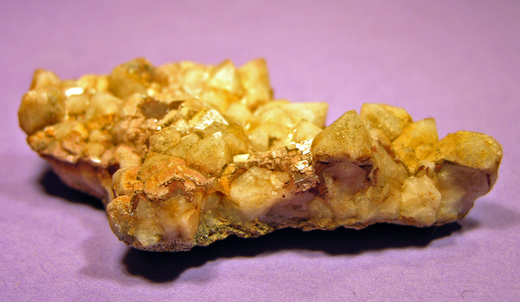


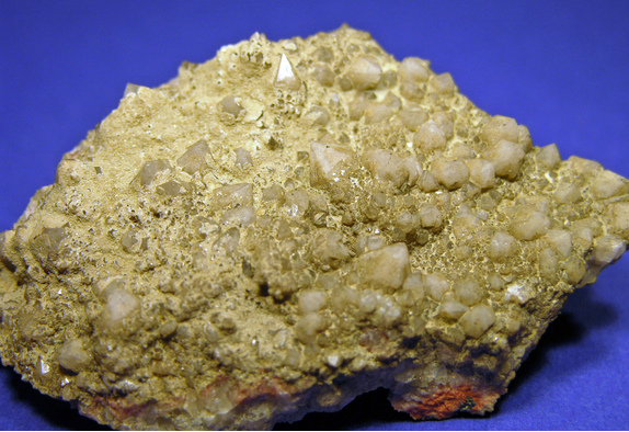


Kalixforsbron, Kiruna, Norrbotten County, Sweden