| Locality type: | Quarry |
| Classification |
|---|
|
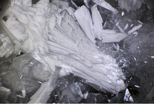
| Species: | Laumontite |
| Formula: | CaAl2Si4O12 · 4H2O |
| Confirmation |
|---|
|
| Validity: | Believed Valid |
| Associated Minerals Based on Photo Data: |
|---|
|
| Heulandite Subgroup | ⓘ6 photos of Laumontite associated with Heulandite Subgroup at this locality. |
| Yugawaralite | ⓘ5 photos of Laumontite associated with Yugawaralite at this locality. |
| Stilbite Subgroup | ⓘ3 photos of Laumontite associated with Stilbite Subgroup at this locality. |
| Chabazite | ⓘ3 photos of Laumontite associated with Chabazite at this locality. |
| Scolecite | ⓘ2 photos of Laumontite associated with Scolecite at this locality. |
| Data |
|---|
|
| Mineral Data: | Click here to view Laumontite data |
| Locality Data: | Click here to view Baird Creek Quarry, Wolf Point, Cowlitz County, Washington, USA |
| Photo Gallery | View Gallery (8 photos) |
| Data Identifiers |
|---|
|
| Mindat Occurrence Record ID: | 648267 |
| Long-form Identifier: | 1:3:648267:1 |
| GUID (UUID V4): | d38a63f6-d112-4db0-ac9f-09197175d495 |
| Nearest other occurrences of Laumontite |
|---|
|
|
| 1.7km (1.0 miles) | ⓘ200 / 237 Road Quarry, Wolf Point, Cowlitz County, Washington, USA |
| 29.6km (18.4 miles) | ⓘRoadcuts, Kalama area, Cowlitz County, Washington, USA |
| 38.2km (23.7 miles) | ⓘRiffe Lake, Kosmos, Lewis County, Washington, USA |
| 39.3km (24.4 miles) | ⓘMossyrock Dam, Morton, Morton Mining District, Lewis County, Washington, USA |
| 39.4km (24.5 miles) | ⓘBig Tree Creek, Yacolt, Clark County, Washington, USA |
| 51.5km (32.0 miles) | ⓘClinton Knob, Ryderwood, Lewis County, Washington, USA |
| 54.0km (33.6 miles) | ⓘLacamas Creek, Orchards, Clark County, Washington, USA |
| 59.2km (36.8 miles) | ⓘThe Half Round Roadcut, Lewis County, Washington, USA |
| 59.6km (37.1 miles) | ⓘLivingston Quarry, Orchards, Clark County, Washington, USA |
| 66.3km (41.2 miles) | ⓘSkookumchuck Dam, Bucoda, Thurston County, Washington, USA |
| References |
|---|
|
|
| Reference Search (possible matching items) |
|---|
 | | Journal (issue) | | .......... VANCOUVER, WASHINGTON May 6, 2000 9:30 am to 6:30 pm Clark County P. U. D. Building 1200...1200 Fort Vancouver Way Vancouver, Washington Rudy will be back meeting with us, so bring your new zeolites...please plan to join us. Mill . Vancouver Way Washington Interstate Bridge Columbia River Oregon 2...SCOLECITE AND MESOLITE AT THE BAIRD CREEK QUARRY, WOLF POINT, COWLITZ COUNTY, WASHINGTON by Rudy W. Tschcmich...flow exposed in a quarry at the headwaters of Baird Creek, southeast of Wolf Point in the Mount Saint |  | | Journal (issue) | | ...... .VANCOUVER, WASHINGTON November 11, 2000 9:30 am to 6:30 pm Clark County P. U. D. Building 1200...1200 Fort Vancouver \Vay Vancouver, Washington Once again we have a day to talk rocks and share collecting...together, so please plan to join us_ Vancouver Way Washington Interstate Bridge Columbia River Oregon 2...PE ELL, LEWIS COUNTY, WASHINGTON by Rudy W. Tschernich 526 Avenue A Snohomish, Washington 98290 Datolite...of Pe Ell, and northwest of Ryderwood, in Lewis County (N46° 24' 44.1" Wl23 1' 16' 45.4 or NE1/4NEI/4 |
|


Baird Creek Quarry, Wolf Point, Cowlitz County, Washington, USA