 | | | | MUSEUM Ag ates Treasures of the Earth Essex County Council Many libraries in Essex have compact discs...images Front cover top Agate from Germany; bottom Agate from Scotland. Back cover Agate from Germany. Title...Title page Agate from Russian Arctic coast. Distribution NBN International Estover Road Devon PL6 7PY ... Contents Introduction Names of agates What is an agate? Properties of agates Sources of agates Europe...different geological environments. Since the mid-1900s, agate collecting has become very popular in Europe, North |  | | Journal (issue) | | WASHINGTON November 3, 2007 9:00 am to 5:00 pm Clark County P. U. D. Building 1200 Fort Vancouver Way Vancouver... Vancouver Way Columbia River 2 ARSENIC IN AGATE by Don Howard and Rudy Tschernich Unusual red, yellow... and black inclusions described as sagenite in agate were first found in the late 1940’s by Ceil Stickney...of Eugene, Oregon near the town of Trent in Lane County, Oregon, just southeast of Springfield/Eugene (Staples...the agate locality, with erroneous information published. The material was found in a railroad cut and |  | | Book (edition) | | formation, cause of color, and how to handle and cut. The only complete opal book. Nine gorgeous colar...areas. Price: $2.00. THE AGATE BOOK-by H. C. Dake. A special book for the agate hunter, collector and cutter...subvarieties of agate. The first complete book on agate with 50 photos showing various types of agate, localities...practically oil phases of the art of gem cutting. How to cut cabochons, faceted stones, specialties and novelties...Localities Beaches Map of Oregon Beaches JACKSON COUNTY A Mineral Mecca Mop of Josephine and Jackson Counties |  | | Report (Issue volume) | | Quebec; perthite and rose quartz from Ontario; and agate, chalcedony and jasper from various localities in...good places to search for minerals, also road and railway cuts; rock exposures along cliffs and along the...Pacific railway and can be reached by way of the lake, or by a disused road leading from the railway tracks...more or less parallel to the Canadian National railway. Notable occurrences are in the vicinity of Shabaqua...vein exposed by pits along the Canadian National railway near Silver Harbour station. The amethyst forms |  | | Book (edition) | | Fraser River: agate, rhodonite, jasper . . . . . . . . . . . . . . 4. Fraser River North: agate, jade . ..... . . . . . . . . . . . 17. Vermillion Bluffs: agate, common opal, petrified wood. 18. Coalmont Road:...37 ROCKS 5 HOPE TO CACHE CREEK 22. Hope: jade, agate, jasper, garnet . . . . . . . . . . . . . . . ..... . . . . . . . . . 41 23. Ainslie Road North: agate . . . . . . . . . . . . . . . . . . . . . . . 42...Springs South: smoky agate, plume agate . . . . . . 46 26. Santa Claus Rock: agate, opal, calcite . . |  | | Book (volume) | | Stebbing, Adam Villazambo and Frank Tierney in the lower Mainland. A special thanks to Win Robertson, who...ranched for three generations under the slide on Agate Mountain; to Bob Bouvette, retired Lillooet prospector...base of our hobby, covering the area around the Lower Mainland. Remember that rockhounding requires no...prospecting methods 8.4 Agate 8.4.1 8.4.2 8.4.3 8.5 Other 9. What is agate? Hunting for agate Thundereggs material...of voids). These gaps may later be filled with agate, calcite or zeolite minerals, to become amygdaloidal |  | | Report (Issue volume) | | Quebec; pcrthite and rose quartz from Ontario; and agate, chalcedony and jasper from various loc::ilitics...ELLESMERE ISLAND (39 St and 29 St Kane Basin) Agate Lemon-yellow translucent aga te is fo und as loose...Lake: from Ruby, Otter, Wright, McKee, Spruce, Lower Spruce and Pine creeks; from Birch Creek which was...about t mile north of the head of the lower canyon in the lower l t miles of the creek; most of them are...the mouth of the Hyland River. Mr. Fred Allen of Lower Post is reported to have found a boulder of excellent |  | | Book | | Chalcedony - 161 to 163 • º • 161 - e -> 162 Agate, &c. • Onyx, Jasper, &c. Illustrations of the Formation... 41 & 42. RED-OxIDE, massive. Knockmahon Mine, County Water ..ford, Ireland. Presented by J. Petherick...and crystallized, capillary. Knockmahon Mines, County Water ford, Ireland. 44. CUPRITE (Red oxide of...(Melaconite). Cornwall. 62. BLACK OxIDE. Cronebane Mine, County Wicklow, Ireland. stone formation (containing...MALACHITE, with Copper Pyrites. Cosheen Mine, County Cork, 95. MALACHITE (dark green), fibrous radiating |  | | Report (issue) | | revealed during the building of the Canadian Pacific railway in 1883 and led to a prospecting rush in the next...Wanapitei; 2. 100 yards north of the Canadian Pacific railway on the north side of the highway 1/ 4 mile east...of the Geological Survey building in Ottawa was cut from a boulder of this rock. Exposures are along...the explorer David Thompson . The road-side sign "Agate Sand Acres" refers to a cottage development on the...Michipicoten Harbour. Michipicoten Island Deposits AGATE, JASPER, CHALCEDONY, AMETHYST. As nodules and seams |  | | Journal (issue) | | Anderson Uranium Mine for Carnotite, Weeksite, Agate, Fluorite (Jeff Craig) leader. • Refer to May 2018... WULFENITE, Red Cloud Mine, Trigo Mts., La Paz County, Arizona, USA; © Chris Whitney-Smith. Page 11...Fe2O3, Crystal Cavern Mine, Dome Rock Mts, La Paz County, Arizona, USA, Ex. Dave Shannon Collection; Marc...Al2Si4O10(OH)2, Crystal Cavern Mine; Dome Rock Mts, La Paz County, Arizona, USA, Ray Grant Photo. ZUNYITE, Al13Si5O20(OH...called Electric Meat Ball Mine Dome Rock Mts, La Paz County, Arizona, USA, Harvard Collection on display at |  | | Report (issue) | | Outcr'op of Mowry shale on Thornton dome, Weston County, Wyo.; B, Hand specimen of Mowry shale collected...from Crook County, Wyo.; B, Thin section of Mowry shale from Thornton dome, Weston County, Wyo_ __ _...Corinth, Howard County, Ark.; B, Basal gravel of \Yoodbine formation, near Horatio, Sevier County, Ark_ _ _...of Cretaceous volcano, near Murfreesboro, Pike County, Ark______ 20. Geologic map of pn,rts of Arkansas...Howard County, Ark.; C., Orthoclase crystal partly replaced by calcite, Owen place, Howard County, Ark |  | | Report (issue) | | C. A. Michael. COLD NUGGET FROM SPOTSYLVANIA COUNTY: Longest dimension approximately 13 cm., photograph...updated “check list” just alluded to, (2) a county-by-county listing of the minerals, and (3) resumes of...quartz) (Rose quartz) (Star quartz) (Chalcedony) (Agate) (Prase) ' (Onyx) (Jasper) (Opal) Tridymitc Qf-Christobalitc...(Haydcnitc) 9 Virginia Mineral Localities by County This list is included for possible aid in planning...listed only* if localities arc given for them. The county lists do not include com mon rock-making materials |  | | Book | | 11ne 2; ••• Amph1bo1ite--see Bolton, Worcester County M1nera1 Loca11t1es. page 85 ••• 11.8 3~ter cerium...•••••••••••••••••'.' •.••.•••• 2--6 Barn.table County ro •• il Localiti ••••••••••••••••••••••••••••...Localit1e•••••••••••••••••••••••••••• 21 Br1.tol County Mineral Localit1 ••••••••••••••••••••••••••••••...24--25 Dukes County Mineral Loeal1tiea •••••••••••••••••••••••••••••• 26--21 Duk •• County Fo.sil Loeal1tie...Local1t1es •••••••••••••••••••••••••••••• 29--3? Bs.ex County Fo ••1l Localit1e •••••••••••••••••••••••••••••••• |  | | Journal (issue) | | eri te is f ound on the su!'fac ~ of nodules of agate and calcite, When dug the material is very durable...durable a.r:1d c an be t rm:.ted l:.ke collecting agate . Wlum at home t hose noduJ.e s containing fer:rierite...on th::. north shor e of Kamloops Lake in a railway cut and along the b each of t he; lake. Col l ecting |  | | Report (issue) | | hair-like crystals in vugs and open spaces in the lower, nonproductive workings of the mines appears to...llage ofActinolite in Elzevir Township, Hastings County . 31 F /1 5 Chemi cal analysis of a light greenish...actino l ite from Westmeath Township , Renfrew County: Si0 2 56 . 70 , Al 0 3 1. 62 , Fe o 3 . 06 , FeO...Township of St . Francis (Beauceville ) , Beauce County : Si0 52 . 30 , Al 2 o 1 . 30 , FeO 6 . 75, 2 3...below French River station on the Canadian Pacific Railway, has been described . It occurs in nepheline syenite |  | | Report (issue) | | Morrow Series and adjacent rocks in Washington County, Ark _____________ _ 2. 3. 4. 5. 6. 7. 8. 9. 10...(See Pettijohn, 1949, p. 476.) Modification of lower grade than metamorphism is understood. ACKNOWLEDGMENTS...1). The type area of the series is in Washington County, Ark. In decreasing order of volume, the rocks...marine sand· stone and clay · pebble conglomerate in lower part co ntain redeposited Pitkin Limestone. Locally...Morrow Series and adjacent rocks in Washington County, Ark. The topographic expression of the rock units |  | | Report (volume) | | Eiver Section from north to south, through Barber County.......................................... Fig...Creek, Meade County ............................ Section across a small ravine, Harper County ............down the east side of a small ravine in Harper County ...... Section near Wichita......................Meade County ........................................... Section on Kiowa Creek, Comanche County.................................... Section in Norton County. .......................................... Tertiary |  | | Report (issue) | | B. Abandoned shore line of Lake Superior, Cook County VII. A. Pot Hole Falls, Brule River, r0 miles above...from St. Paul through Chisago County 44 5. Highway No. I through Pine County.. . . . . . . . . . . . . ..... 53 6. Highway No. I through Carlton County. . . . . . . . . . . .. 57 7. The Duluth region .........established at Sandy Lake in the central part of Aitkin County. 1 Folwell, "V. VV., A history of Minnesota, vol...the northeast part of the state, in western Cook County. A large part of the state falls between 1000 and |  | | Report (issue) | | Centennial (Kitchigami) Mine Michipicoten Island agate occurrences Michipicoten Island copper occurrences...Winnipegosis quarries Mafeking quarries Highway 10 road-cut Souris gravel pit Silver Plains Mine Morden selenite...calcite crystals, Copper Creek Mine Grace Mine Agate cabochons, Lake Superior Quebec Mine, Michipicoten...Sault Ste. Marie to Thunder Bay, describes the agate and jasper occurrences and early gold, silver and...'micro' minerals, ornamental rock, selenite, and agate and jasper. Among the occurrences described in the |  | | Book (edition) | | Co\·er photo: \\ 7 ulfenite, Rowley Mine, Maricopa County, 4 cm high specimen, Evan and Melissa Jones Collection...gemandmineralmuseum.arizona.edu) is located in the old Pima County Courthouse building at 115 North Church Avenue...on the market. The mines at Bisbee, in Cochise County, have produced large quantities of gem-quality...mineral stamp issued in 1992. At Morenci, in Greenlee County, gem-quality azurite was also commercially recovered...stalactitic formations were cut across the grain and when banded material was cut parallel to the grain. The |  | | Report (issue) | | _:_________________ Flaxville Plain in Blaine County _______ ------------------ __________________________...~-..;.-------~o. 1 or Flaxville terrace on the lower Yellowstone---------------------------------------------------..._____ --:..- __ --------Drift on ridge west of Lower St. Mary Lake------------~------------------------..._______ :.. ____________ ~___ Carlow Flat, Glacier County ____________________________________________________________...--------------------------~o. 2 terrace on the lower Yellowstone------------------------------------------------ |  | | Journal (article/letter/editorial) | | in Borax Lake, one mile north of Manakee, Lake County. Principal literature: Harrington (1938a; 1938b);...Altaville in the south western part of Calaveras County, discovered about 1866. Principal literature: Becker...Cave.—Locality on Potter Creek, near Baird, Shasta County, explored, 1902-03; announced, Sinclair, 1904....—Locality in the northeastern part of Riverside County, discovered, 1935; announced, Campbell and Campbell...McCloud River about 16 miles above its mouth, Shasta County, discovered, 1903; announced, Furlong, 1904. Principal |  | | Journal (article/letter/editorial) | | Carboniferous limestone sequence that was cut during excavations for a railway tunnel (in 1865) has provided a...comprises an upper pale limestone facies and a lower dark limestone facies. It is the latter that underlies...and volume of 2.5–3.5 mm thick tablets, which are cut from 40 mm diameter cores to produce a relatively...surfaces. The dated surfaces comprise the cut faces of a former railway cutting in the Monsal Dale Limestone...Manchester, Buxton, Matlock and Midland Junction Railway. The southern section (Ambergate to Rowsley) was |  | | Report (volume) | | .............................. .. ....... 87 Poland, Siberia, 87-Caucasus, 88. Spain ...............Fredenevllle, 121-Blair county, 122-Lancaeter county, 123-Northnmberland county, Chester county, 12~. New Jersey........ 125 Sterling Hlll, Mine Hill, 12G-Warren county, 127. Maryland ............. .... ..............Washington mine, Silver Valley mine, 132-Cabarrus county, Union connt:r, Montgomery conn ty, 133. Tennessee...Livingston county, 151-The Royal Mines, 153-Crittenden county, The Columbia mines, 164-Caldwell county, 155 |  | | Report (issue) | | pp. 305-314, 1922. 19 Arnold, R. Coal in Clallam County, Washington. U. S. Geol. Surv., Bull. no. 260,...Geol., vol. 1, no. 1, pp. 1-67, 1916. of the Lower of of Kitsap 88 Weaver, Washington. C. E..., and of West- Valley, Washington. Proc. County, Western Washington. Washington. Washington...Columella somewhat fascicular, in some sections cut near the calice, however, the columellar space seems...no complete from specimen of the longer the lower Oligocene sand- stone and conglomerate at Gries |
|
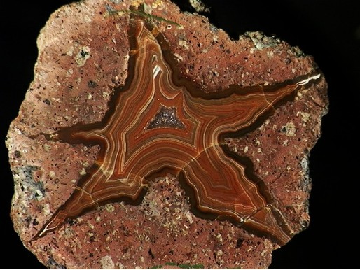


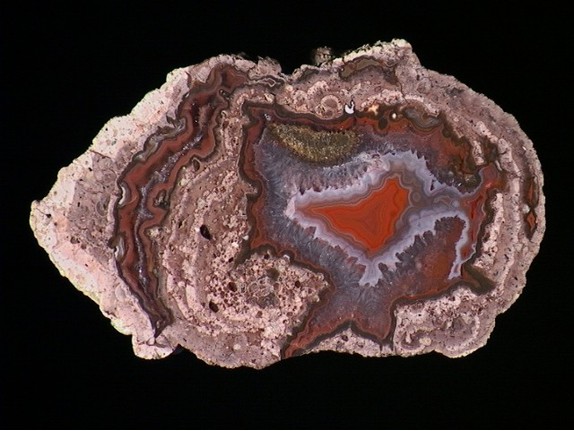
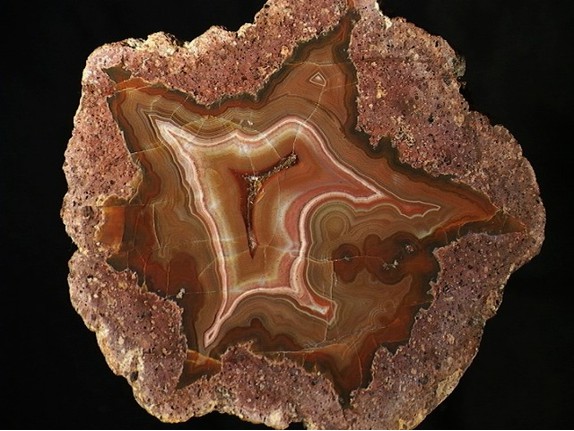


Railway cut, Nowy Kościół, Gmina Świerzawa, Złotoryja County, Lower Silesian Voivodeship, Poland