| Locality type: | Quarry |
| Classification |
|---|
|
| Species: | Pyrite |
| Formula: | FeS2 |
| Confirmation |
|---|
|
| Validity: | Confirmed |
| Confirmation Methods: | Visually Identified |
| Data |
|---|
|
| Mineral Data: | Click here to view Pyrite data |
| Locality Data: | Click here to view Mt Bertha Quarry, Mt Bertha Road, South Arthur Forests, Trowutta, Arthur River district, Circular Head municipality, Tasmania, Australia |
| Photo Gallery | View Gallery (2 photos) |
| Data Identifiers |
|---|
|
| Mindat Occurrence Record ID: | 850916 |
| Long-form Identifier: | 1:3:850916:1 |
| GUID (UUID V4): | 4c77b021-8516-44e9-9076-669ef4df6f97 |
| Nearest other occurrences of Pyrite |
|---|
|
|
| 10.1km (6.3 miles) | ⓘTayatea Quarry, Trowutta, Arthur River district, Circular Head municipality, Tasmania, Australia |
| 11.1km (6.9 miles) | ⓘArthur River district, Circular Head municipality, Tasmania, Australia |
| 16.4km (10.2 miles) | ⓘTayatea bridge, Trowutta, Arthur River district, Circular Head municipality, Tasmania, Australia |
| 16.5km (10.2 miles) | ⓘBlackwater Road, Arthur River district, Circular Head municipality, Tasmania, Australia |
| 19.3km (12.0 miles) | ⓘHolder No. 1 Quarry, Trowutta, Arthur River district, Circular Head municipality, Tasmania, Australia |
| 19.5km (12.1 miles) | ⓘMurrays Reward mine, Balfour, Balfour-Temma district, Circular Head municipality, Tasmania, Australia |
| 19.7km (12.2 miles) | ⓘDollie pit, Wedge Plains Road, Dollie Creek, Trowutta, Arthur River district, Circular Head municipality, Tasmania, Australia |
| 20.1km (12.5 miles) | ⓘSpecimen Hill, Balfour, Balfour-Temma district, Circular Head municipality, Tasmania, Australia |
| 25.3km (15.7 miles) | ⓘRoaring 32S, Balfour-Temma district, Circular Head municipality, Tasmania, Australia |
| 30.8km (19.1 miles) | ⓘSavage River Mines, Corinna-Savage River district, Waratah-Wynyard municipality, Tasmania, Australia |
| References |
|---|
|
|
| Reference Search (possible matching items) |
|---|
 | | Corporate Document (Series) | | A Catalogue of the Minerals of Tasmania Geological Survey Bulletin 73 by R. S. Bottrill and W. E. Baker...Baker Mineral Resources Tasmania Department of Infrastructure, Energy and Resources E>...rossi'oilittes PO Box 56 Rosny Park Tasmania 7018 Phone (03) 6233 8377 Fax (03) 6233 8338 Email info@mrt...gov.au First published in Australia in 2008 by Mineral Resources Tasmania Department of Infrastructure...Box 56, Rosny Park, Tasmania 7018 www.mrttas.gov.au ©Copyright State of Tasmania, 2008 All rights reserved |  | | Book | | into the Coast Plutonic Complex sill along the south shore of Tracy Arm. Sun and glacial silt produce...islands have complex coastlines of bays, inlets, and river estuaries. The result is a rugged, generally tree-covered...Alaska. High in the mountains, cirques form when the head of a valley glacier carves a steep-sided bowl-shaped...sea level on the south side of Sweetheart Ridge. The 6,666-foot (2,020-m) summit of Mt. Sumdum is in the...in a glacier. Tracy Arm, about 50 miles (80 km) south of Juneau, is more than 1,200 feet (360 m) deep |  | | Book (edition) | | Press Publishing Company P.O. Box 2399 Missoula, MT 59805 (406) 728-1900 To the men and women who have...Elsewhere, the routes are described east to west or south to north. The ferry routes are treated just like...and the Copper River basin. Dan O’Haire lives in Anchor¬ age and was responsible for south-central and interior...interior Alaska, plus the Pipeline Haul Road and Nome. We hope our collaboration meshes neatly into a...Junction—Fairbanks.129 Tetlin Junction—Eagle.133 Chapter III. South-Central Alaska.137 Anchorage and the Kenai Peninsula |  | Brew, David A., Johnson, B.R., Grybeck, Donald, Griscom, Andrew, Barnes, D.F., Kimball, A.L., Still, J.C., Rataj, J.I. (1978) Mineral resources of the Glacier Bay National Monument Wilderness Study Area, Alaska. Open-File Report Vol. 1978 (78-494) US Geological Survey doi:10.3133/ofr78494 | Report (issue) | | David F. Barnes, U.S. Geological Survey and by Arthur L. Kimball, Jan C. Still, and Jeanne L. Rataj,...Correlation studies 23 24 Mineral resources, by Arthur L. Kimball, Jan C. Still, and Jeanne L. Rataj...stock C-101 North wall of the South Crillon Glacier C-101 South wall of the North Crillon Glacier...sulfide showings ' C -14 7 3,087 nunatak 0^147 i South side of Johns Hopkins Inlet C-147 i Margerie Glacier...along prospect C-236 Whirlaway prospect C-237 Mt. Parker area C-: 237 Russell Island gold prospect |
|


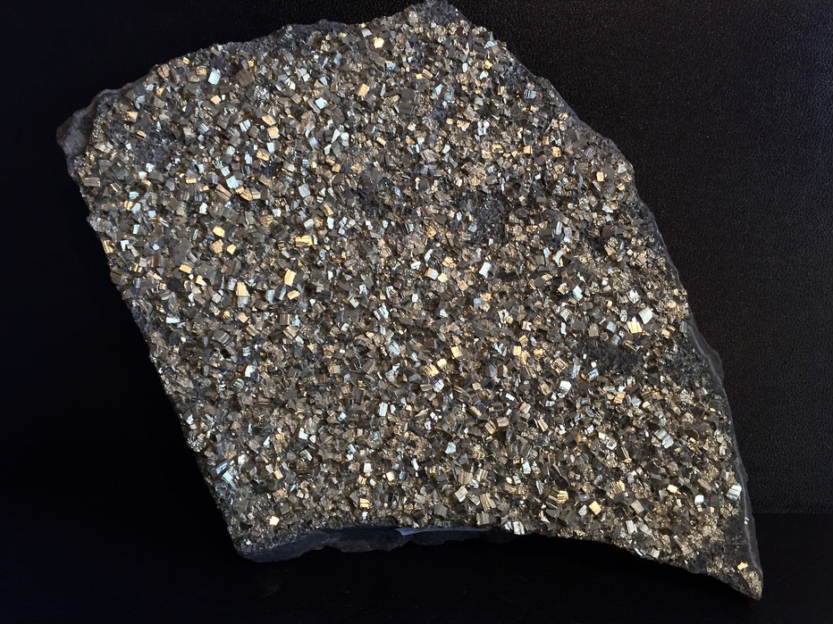


Mt Bertha Quarry, Mt Bertha Road, South Arthur Forests, Trowutta, Arthur River district, Circular Head municipality, Tasmania, Australia