Woodville, Sandusky County, Ohio, USAi
| Regional Level Types | |
|---|---|
| Woodville | - not defined - |
| Sandusky County | County |
| Ohio | State |
| USA | Country |
This page is currently not sponsored. Click here to sponsor this page.


Latitude & Longitude (WGS84):
41° 27' 4'' North , 83° 21' 57'' West
Latitude & Longitude (decimal):
Köppen climate type:
Nearest Settlements:
| Place | Population | Distance |
|---|---|---|
| Woodville | 2,083 (2017) | 0.0km |
| Elmore | 1,393 (2017) | 6.5km |
| Genoa | 2,306 (2017) | 7.5km |
| Gibsonburg | 2,564 (2017) | 8.3km |
| Pemberville | 1,423 (2017) | 9.1km |
Nearest Clubs:
Local clubs are the best way to get access to collecting localities
Local clubs are the best way to get access to collecting localities
| Club | Location | Distance |
|---|---|---|
| Toledo Gem & Rockhound Club | Toledo, Ohio | 28km |
Mindat Locality ID:
179934
Long-form identifier:
mindat:1:2:179934:0
GUID (UUID V4):
4419737c-6ce0-467d-b4e1-0362fcddc739
The following information is from Woodville Township website:
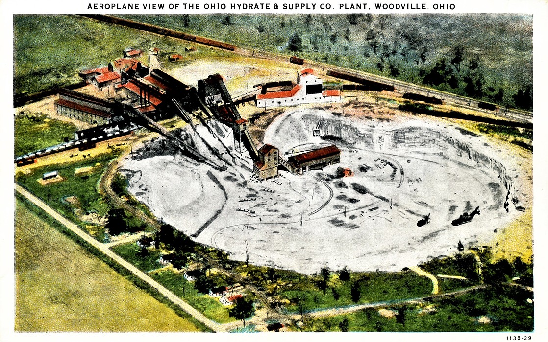
The first lime in the area was produced in the 1840s by Fred Miller in the area of the George Hagedorn farm, off of Lime Road. Miller hauled a large part of his product by wagon to Toledo and Perrysburg. The first modern lime plant was erected in 1872. This plant was named the Woodville Lime Products Company, now a part of Martin Marietta. The Ohio Hydrate and Supply Company (the former Ohio Lime Company) and Standard Lime and Stone Company (now a part of Martin Marietta) were the early lime plants in the area.
Select Mineral List Type
Standard Detailed Gallery Strunz Chemical ElementsCommodity List
This is a list of exploitable or exploited mineral commodities recorded from this region.Mineral List
Mineral list contains entries from the region specified including sub-localities9 valid minerals.
Detailed Mineral List:

List of minerals arranged by Strunz 10th Edition classification
| Group 2 - Sulphides and Sulfosalts | |||
|---|---|---|---|
| ⓘ | Sphalerite | 2.CB.05a | ZnS |
| ⓘ | Galena | 2.CD.10 | PbS |
| ⓘ | Pyrite | 2.EB.05a | FeS2 |
| Group 3 - Halides | |||
| ⓘ | Fluorite | 3.AB.25 | CaF2 |
| Group 5 - Nitrates and Carbonates | |||
| ⓘ | Calcite | 5.AB.05 | CaCO3 |
| ⓘ | Dolomite | 5.AB.10 | CaMg(CO3)2 |
| ⓘ | Strontianite | 5.AB.15 | SrCO3 |
| Group 7 - Sulphates, Chromates, Molybdates and Tungstates | |||
| ⓘ | Baryte | 7.AD.35 | BaSO4 |
| ⓘ | Celestine | 7.AD.35 | SrSO4 |
List of minerals for each chemical element
| C | Carbon | |
|---|---|---|
| C | ⓘ Calcite | CaCO3 |
| C | ⓘ Dolomite | CaMg(CO3)2 |
| C | ⓘ Strontianite | SrCO3 |
| O | Oxygen | |
| O | ⓘ Baryte | BaSO4 |
| O | ⓘ Calcite | CaCO3 |
| O | ⓘ Celestine | SrSO4 |
| O | ⓘ Dolomite | CaMg(CO3)2 |
| O | ⓘ Strontianite | SrCO3 |
| F | Fluorine | |
| F | ⓘ Fluorite | CaF2 |
| Mg | Magnesium | |
| Mg | ⓘ Dolomite | CaMg(CO3)2 |
| S | Sulfur | |
| S | ⓘ Baryte | BaSO4 |
| S | ⓘ Celestine | SrSO4 |
| S | ⓘ Galena | PbS |
| S | ⓘ Pyrite | FeS2 |
| S | ⓘ Sphalerite | ZnS |
| Ca | Calcium | |
| Ca | ⓘ Calcite | CaCO3 |
| Ca | ⓘ Dolomite | CaMg(CO3)2 |
| Ca | ⓘ Fluorite | CaF2 |
| Fe | Iron | |
| Fe | ⓘ Pyrite | FeS2 |
| Zn | Zinc | |
| Zn | ⓘ Sphalerite | ZnS |
| Sr | Strontium | |
| Sr | ⓘ Celestine | SrSO4 |
| Sr | ⓘ Strontianite | SrCO3 |
| Ba | Barium | |
| Ba | ⓘ Baryte | BaSO4 |
| Pb | Lead | |
| Pb | ⓘ Galena | PbS |
Localities in this Region
Other Regions, Features and Areas containing this locality
North America PlateTectonic Plate
- Shawnee DomainDomain
This page contains all mineral locality references listed on mindat.org. This does not claim to be a complete list. If you know of more minerals from this site, please register so you can add to our database. This locality information is for reference purposes only. You should never attempt to
visit any sites listed in mindat.org without first ensuring that you have the permission of the land and/or mineral rights holders
for access and that you are aware of all safety precautions necessary.


Woodville, Sandusky County, Ohio, USA