| Locality | Latitude | Longitude | Distance | Bearing |
|---|
| Cates Hill, Berlin, Coos County, New Hampshire, USA | 44° 30' 28" N | 71° 10' 55" W | 0.0km (0.0 miles) | |
| Berlin, Coos County, New Hampshire, USA | 44° 28' 6" N | 71° 11' 2" W | 4.4km (2.7 miles) | |
| Milan, Coos County, New Hampshire, USA | 44° 34' 23" N | 71° 11' 6" W | 7.3km (4.5 miles) | |
| Milan Mine, Milan, Coos County, New Hampshire, USA | 44° 33' 57" N | 71° 15' 27" W | 8.8km (5.5 miles) | |
| Dummer, Coos County, New Hampshire, USA | 44° 36' 38" N | 71° 12' 2" W | 11.5km (7.2 miles) | |
| Gorham, Coos County, New Hampshire, USA | 44° 23' 16" N | 71° 10' 23" W | 13.4km (8.3 miles) | |
| Shelburne, Coos County, New Hampshire, USA | 44° 24' 3" N | 71° 4' 28" W | 14.6km (9.1 miles) | |
| Kilkenny, Coos County, New Hampshire, USA | 44° 29' 43" N | 71° 23' 32" W | 16.7km (10.4 miles) | |
| Mill Mountain, Stark, Coos County, New Hampshire, USA | 44° 35' 53" N | 71° 23' 11" W | 19.0km (11.8 miles) | |
| Stark, Coos County, New Hampshire, USA | 44° 36' 34" N | 71° 24' 33" W | 21.3km (13.2 miles) | |
| Hutchins Mountain, Stark, Coos County, New Hampshire, USA | 44° 32' 53" N | 71° 27' 17" W | 22.1km (13.7 miles) | |
| Bean's Purchase, Coos County, New Hampshire, USA | 44° 17' 39" N | 71° 8' 18" W | 24.0km (14.9 miles) | |
| Long Mountain, Stark, Coos County, New Hampshire, USA | 44° 40' 50" N | 71° 22' 50" W | 24.8km (15.4 miles) | |
| South Percy Peak locality, Stratford, Coos County, New Hampshire, USA | 44° 39' 23" N | 71° 26' 6" W | 26.0km (16.1 miles) | |
| North Percy Peak locality, Stratford, Coos County, New Hampshire, USA | 44° 39' 47" N | 71° 26' 8" W | 26.5km (16.5 miles) | |
| Glen Ellis Falls, Jackson, Carroll County, New Hampshire, USA | 44° 14' 38" N | 71° 15' 5" W | 29.9km (18.6 miles) | |
| Sugarloaf Mountain, Stoneham, Oxford County, Maine, USA | 44° 16' 23" N | 70° 59' 33" W | 30.1km (18.7 miles) | |
| North Baldface Mountain localities, Bean's Purchase, Coos County, New Hampshire, USA | 44° 14' 34" N | 71° 5' 16" W | 30.4km (18.9 miles) | |
| Millard Chandler Mine, Chatham, Carroll County, New Hampshire, USA | 44° 15' 20" N | 71° 1' 34" W | 30.6km (19.0 miles) | |
| Lancaster, Coos County, New Hampshire, USA | 44° 29' 20" N | 71° 34' 9" W | 30.8km (19.1 miles) | |
| South Baldface Mountain localities, Chatham, Carroll County, New Hampshire, USA | 44° 13' 50" N | 71° 4' 41" W | 31.9km (19.8 miles) | |
| Bean's Grant, Coos County, New Hampshire, USA | 44° 15' 12" N | 71° 22' 23" W | 32.1km (19.9 miles) | |
| Cherry Mountain, Carroll, Coos County, New Hampshire, USA | 44° 18' 51" N | 71° 29' 31" W | 32.7km (20.3 miles) | |
| Rattlesnake Mountain locality, Stoneham, Oxford County, Maine, USA | 44° 15' 5" N | 70° 58' 2" W | 33.2km (20.6 miles) | |
| Sargents Purchase, Coos County, New Hampshire, USA | 44° 13' 9" N | 71° 18' 1" W | 33.4km (20.8 miles) | |
| Beryllonite Locality (Mcallister Occurrence), Stoneham, Oxford County, Maine, USA | 44° 16' 6" N | 70° 55' 27" W | 33.6km (20.9 miles) | |
| Melrose Quarry, Stoneham, Oxford County, Maine, USA | 44° 16' 5" N | 70° 55' 20" W | 33.7km (20.9 miles) | |
| Stratford, Coos County, New Hampshire, USA | 44° 39' 15" N | 71° 33' 30" W | 34.0km (21.1 miles) | |
| Eastman Quarry, Deer Hill, Stow, Oxford County, Maine, USA | 44° 14' 8" N | 70° 59' 12" W | 34.0km (21.1 miles) | |
| Deer Hill, Stow, Oxford County, Maine, USA | 44° 14' 8" N | 70° 59' 13" W | 34.0km (21.1 miles) | |

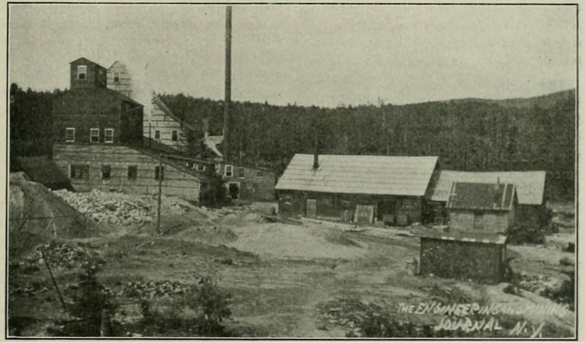


Berlin, Coos County, New Hampshire, USA