Sand Mountain, Churchill Co., Nevada, USAi
| Regional Level Types | |
|---|---|
| Sand Mountain | - not defined - |
| Churchill Co. | County |
| Nevada | State |
| USA | Country |


| Latitude & Longitude (WGS84): | 39° 18' 30'' North , 118° 23' 49'' West | |||||||||
|---|---|---|---|---|---|---|---|---|---|---|
| Latitude & Longitude (decimal): | 39.30853,-118.39708 | |||||||||
| GeoHash: | G#: 9qgz9gcuu | |||||||||
| Köppen climate type: | BWk : Cold desert climate | |||||||||
| Nearest Settlements: |
|
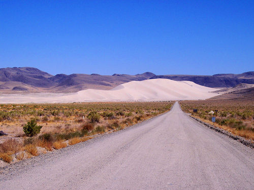
Sand Mountain is a very large group of sand dunes that is two miles long and 600 feet high. It is located 20 miles east of Fallon, Nevada near highway 50. This imposing geological feature is part of the Sand Mountain Recreation Area. It is also the location of the Sand Springs Pony Express Station constructed in 1860 from black and brown vesicular basalt cobbles taken from the surrounding hills.
Sand Mountain is the result of a sequence of events that started about 1.5 million years ago. From then until about 14,000 years ago there were five glacial periods in the Serra Nevada Mountains. An ice cap formed over the highest peaks that was unique to the Serra Nevada Range. The southward extent of the Wisconsin ice cap terminated just south of the Canadian border in northern Washington, Idaho and Montana. During the five advances and retreats of the Serra Nevada ice cap the outwash followed the watersheds of the Carson and Truckee Rivers into the Great Basin forming prehistoric Lake Lahontan.
Lake Lahontan was huge covering 8,500 square miles to a maximum depth of 900 feet. There were peaks and ridges that rose above the water creating an abundance of islands in the lake. About 12,700 years ago the lake peaked and then started to decline. By about 9,000 years ago the lake had almost completely evaporated leaving many playas in the valleys. One of these playas, 12 miles long and 3 miles wide, was the source of the sand. Strong southwesterly winds picked up the grains of quartz and funneled hem into the hills. The hills slowed the wind velocity dropping the sand year after year building the dunes.
Regions containing this locality
| North America Plate | Tectonic Plate |
List of minerals for each chemical element
Regional Geology
This geological map and associated information on rock units at or nearby to the coordinates given for this locality is based on relatively small scale geological maps provided by various national Geological Surveys. This does not necessarily represent the complete geology at this locality but it gives a background for the region in which it is found.
Click on geological units on the map for more information. Click here to view full-screen map on Macrostrat.org
| Holocene - Pleistocene 0 - 2.588 Ma ID: 2965342 | Sand dunes Age: Pleistocene (0 - 2.588 Ma) Description: Unit is present in Clark, Humboldt, Lincoln, Churchill, Washoe, and Pershing Counties. There may be sand dunes in other counties that are not distinguished. Comments: Original map source: Crafford, A.E.J., 2007, Geologic Map of Nevada: U.S. Geological Survey Data Series 249, 1 CD-ROM, 46 p., 1 plate; Scale 1:250,000. Lithology: Major:{sand} Reference: Horton, J.D., C.A. San Juan, and D.B. Stoeser. The State Geologic Map Compilation (SGMC) geodatabase of the conterminous United States. doi: 10.3133/ds1052. U.S. Geological Survey Data Series 1052. [133] |
| Neogene 2.588 - 23.03 Ma ID: 3186305 | Cenozoic volcanic rocks Age: Neogene (2.588 - 23.03 Ma) Stratigraphic Name: Columbia River Basalt Comments: Columbia Plateau Lithology: Flood basalt(s); mafic volcanic rocks; basalt Reference: Chorlton, L.B. Generalized geology of the world: bedrock domains and major faults in GIS format: a small-scale world geology map with an extended geological attribute database. doi: 10.4095/223767. Geological Survey of Canada, Open File 5529. [154] |
Data and map coding provided by Macrostrat.org, used under Creative Commons Attribution 4.0 License


Sand Mountain, Churchill Co., Nevada, USA