| Classification |
|---|
|
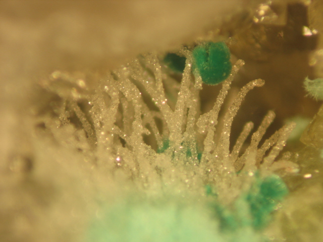
| Species: | Zálesíite |
| Formula: | CaCu6(AsO4)2(AsO3OH)(OH)6 · 3H2O |
| Confirmation |
|---|
|
| Validity: | Believed Valid |
| Associated Minerals Based on Photo Data: |
|---|
|
| Quartz | ⓘ5 photos of Zálesíite associated with Quartz at this locality. |
| Mixite | ⓘ3 photos of Zálesíite associated with Mixite at this locality. |
| Mixite Group | ⓘ2 photos of Zálesíite associated with Mixite Group at this locality. |
| Atelestite | ⓘ1 photo of Zálesíite associated with Atelestite at this locality. |
| Data |
|---|
|
| Mineral Data: | Click here to view Zálesíite data |
| Locality Data: | Click here to view Heidenbach, Munster, Colmar-Ribeauvillé, Haut-Rhin, Grand Est, France |
| Photo Gallery | View Gallery (2 photos) |
| Data Identifiers |
|---|
|
| Mindat Occurrence Record ID: | 354703 |
| Long-form Identifier: | 1:3:354703:8 |
| GUID (UUID V4): | 66039b18-949d-4e74-b220-47bffc907d3a |
| Nearest other occurrences of Zálesíite |
|---|
|
|
| 7.4km (4.6 miles) | ⓘSilver mine, Zimmerbach, Colmar-Ribeauvillé, Haut-Rhin, Grand Est, France |
| 7.7km (4.8 miles) | ⓘAspach, Wintzenheim, Colmar-Ribeauvillé, Haut-Rhin, Grand Est, France |
| 9.1km (5.7 miles) | ⓘCopper deposit, Osenbach, Thann-Guebwiller, Haut-Rhin, Grand Est, France |
| 46.6km (29.0 miles) | ⓘVein No. 3 (Le bas Hérival), Les Roches valley area (Bois de la Vèche area), Faymont, Le Val-d'Ajol, Épinal, Vosges, Grand Est, France |
| 46.9km (29.2 miles) | ⓘLes Roches valley area (Bois de la Vèche area), Faymont, Le Val-d'Ajol, Épinal, Vosges, Grand Est, France |
| 46.9km (29.2 miles) | ⓘLa Corveraine workings, Saphoz, Esmoulières, Lure, Haute-Saône, Bourgogne-Franche-Comté, France |
| 63.7km (39.6 miles) | ⓘOberhepschingen, Fröhnd, Lörrach, Freiburg Region, Baden-Württemberg, Germany |
| 66.0km (41.0 miles) | ⓘLisbühl, Todtnau, Lörrach, Freiburg Region, Baden-Württemberg, Germany |
| 69.0km (42.9 miles) | ⓘMichael Mine, Weiler, Seelbach, Seelbach, Ortenaukreis, Freiburg Region, Baden-Württemberg, Germany |
| 80.9km (50.2 miles) | ⓘSilberbrünnle Mine, Gengenbach, Gengenbach, Ortenaukreis, Freiburg Region, Baden-Württemberg, Germany |
| References |
|---|
|
|


Heidenbach, Munster, Colmar-Ribeauvillé, Haut-Rhin, Grand Est, France