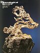
| Locality type: | Valley |
| Classification |
|---|
|
| Species: | Titanite |
| Formula: | CaTi(SiO4)O |
| Confirmation |
|---|
|
| Validity: | Believed Valid |
| Data |
|---|
|
| Mineral Data: | Click here to view Titanite data |
| Locality Data: | Click here to view Upper Hunza Valley, Hunza District, Gilgit-Baltistan, Pakistan |
| Data Identifiers |
|---|
|
| Mindat Occurrence Record ID: | 557835 |
| Long-form Identifier: | 1:3:557835:1 |
| GUID (UUID V4): | 796ba04d-c9ac-429d-a0ac-8b3a266a8ddb |
| Nearest other occurrences of Titanite |
|---|
|
|
| 37.2km (23.1 miles) | ⓘHispar Glacier, Hispar, Nagar District, Gilgit-Baltistan, Pakistan |
| 55.4km (34.4 miles) | ⓘKhaltaro, Gilgit District, Gilgit-Baltistan, Pakistan |
| 70.8km (44.0 miles) | ⓘHanuchal, Gilgit District, Gilgit-Baltistan, Pakistan |
| 77.0km (47.8 miles) | ⓘArondu, Basha Valley, Shigar district, Gilgit-Baltistan, Pakistan |
| 79.5km (49.4 miles) | ⓘGilgit, Gilgit District, Gilgit-Baltistan, Pakistan |
| 79.6km (49.5 miles) | ⓘBagrot Gah, Gilgit District, Gilgit-Baltistan, Pakistan |
| 88.1km (54.8 miles) | ⓘBien Sla, Basha Valley, Shigar District, Gilgit-Baltistan, Pakistan |
| 98.2km (61.0 miles) | ⓘTormiq Valley, Haramosh Mts., Roundu District, Gilgit-Baltistan, Pakistan |
| 99.1km (61.5 miles) | ⓘBasha Valley, Shigar District, Gilgit-Baltistan, Pakistan |
| 99.3km (61.7 miles) | ⓘDassu, Braldu Valley, Shigar District, Gilgit-Baltistan, Pakistan |
| References |
|---|
|
Garnier, V., Giuliani, G., Ohnenstetter, D., Fallick, A.E., Dubessy, J., Banks, D., Vinh, H.Q., Lhomme, T., Maluski, H., Pêcher, A., Bakhsh, K.A., Long, P.V., Trinh, P.T., and Schwarz, D. (2008): Ore Geology Reviews 34, 169-191. |
| Reference Search (possible matching items) |
|---|
 | | Journal (issue) | | from the C en ten n ia l Eureka m in e, T intic district, Juab C ounty, U ta h ..........................Richard also became charter members o f the Tualatin Valley Gem Club and the Friends of Mineralogy. Over the...surrounding valleys. To the west lies the Sacramento Valley, which drains southwest to the Colorado The Mineralogical...River near Needles. To the east is the Hualapai Valley, which drains north into the Red Lake Playa. The...end o f the Wallapai Mining District. The major mining centers of the district included Cerbat, Chloride |  | | Report (volume) | | evolution of the North Karakoram cover, North Pakistan Zi Gaetan, 39 M., JADouL, F., Erpa, E. & Garzanti...Collision-related granitoid structure of the Hunza Karakoram, north Pakistan TreLoar, magmatism P.J. & Izatr,...West Pakistan 89 Aumep, Z. Leucocratic rocks from the Bela ophiolite, Khuzdar district, Pakistan Arir...zone of Pakistan Jan, M.Q., Kuan, North Pakistan Kuan, M.A., JAN, B.L. Evolution Pakistan: temporal...reconstruction of the Dir Group: within Kohistan, N. Pakistan Haynes, J.R. & Rex, D.C. evidence for magmatic |  | | Book (volume) | | surveyor (Bad Shah Jan of the Survey of Pakistan), both from Pakistan, also joined the staff. The scientific...of the Geological Survey of Pakistan, M. Azizullah of the Survey of Pakistan, and Javed, a student at the...between the upper course of the Indus river, from Skardu as far west as the Stak valley, and the principal...westwards as far as Hunza and Gilgit and eastwards as far as Bagicha. the Gilgit area and Chitral. The...Lungma and the Sosbun glaciers, and the upper valley of the Hunza river. Two other light expeditions were |  | Zanchetta, Stefano, Worthington, James, Angiolini, Lucia, Leven, Ernst Ja., Villa, Igor M., Zanchi, Andrea (2018) The Bashgumbaz Complex (Tajikistan): Arc obduction in the Cimmerian orogeny of the Pamir. Gondwana Research, 57. 170-190 doi:10.1016/j.gr.2018.01.009 | Journal (article/letter/editorial) | | mafic-ultramafic nappe exposed along the Alichur Valley in the Pamir, whose significance is of paramount...interleaved within the complex. The BSC, with its upper part, is in contact with a IP sedimentary unit...extends E–W from the E- PT Pamir Fault to the valley of the Panji River (Figs. 1, 2; Burtman & Molnar...obducted ophiolitic nappe exposed along the Alichur Valley, represent a key element of the geology of the...Alichur dome, which extends E-W south of the Alichur Valley, consists of Jurassic to Cretaceous granitoids |
|


