 | | Journal (article/letter/editorial) | | Postcard view of the Waukon iron mine, Allamakee County, cia. 1912. John Taylor collection. ARTHUR E ...Unfortunately. with today’s environmental laws and mine and quarry regulations. the prolific collecting of the 1950s...HAROLD L. PRlOR P.O. Box 111 Columbus Junction, Iowa 52738 halprior@ louisacomm.net When we began this...too, could be cited with many other localities. Iowa contains the type locality for one mineral, iowaite...December 2014 Figure 2. Map of Iowa showing the counties. Courtesy Iowa Geological Survey. ACKNOWLEDGMENTS | 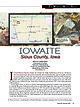 | | Journal (article/letter/editorial) | | Figure 1. The state of Iowa map; prepared by William Besse. IOW AITE Sioux County, Iowa BRUCE CAIRNCROSS ...1,000–1,500 feet below the surface in Sioux County, Iowa (Kohls and Rodda 1967); approximately thirty-five...post-serpentinization chrysotile, dolomite, brucite, calcite, magnesite, and pyrite. Since the description of...of Johannesburg. Volume 93, May/June 2018 271 Iowa has 74 valid species (Mindat.org; accessed March...best known for geodes from the Keokuk area in Lee County (Wherry 1918; Smith 1997; Huizing 2017). The Keokuk | 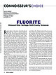 | | Journal (article/letter/editorial) | | pohwatp@si.edu FLUORITE Elmwood Mine, Carthage, Smith County, Tennessee R egular readers of this column will...private), the other two species being quartz and calcite. The reason that these species have such a wide...shade of purple, but it also can be blue, blue-black, red, pink, green, yellow, brown, and colorless...sphalerite, 8.8 cm high, from the Elmwood mine, Smith County, Tennessee. Note the gemmy corners of the cube...pieces are all from the fluorspar district, Hardin County, Illinois. Cincinnati Museum Center specimens, |  | | Journal (article/letter/editorial) | | (bottom left). Homoepitaxy in calcite from the Peske quarry, Black Hawk County, Iowa. The second-generation... Homoepitaxy in catapleiite from the Poudrette quarry, Mont Saint-Hilaire, Quebec, Canada. The first-generation...Homoepitaxy in fluorite from the Denton mine, Hardin County, Illinois. The first-generation crystal is decorated...crystals underneath the second-generation fluorite. Calcite crystals were deposited last and decorate both | 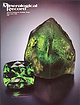 | | Journal (issue) | | matrix; Lhoest collection and photo. / Calcite C aC 03 Calcite forms a noticeable part o f the country-rock...limited blasting has usually been necessary. Most calcite crystals are milky white, opaque to translucent...crystals referred to by collectors as “French fried” calcite. This is m ainlydue to a combination of the very...e 2 6 , M a y - J u n e , 1 9 9 5 Figure 32. Calcite crystals (of the “French fry” habit), 8 cm across;... {0112} Figure 33. Calcite crystal drawing (Buttgenbach, 1947). Figure 34. Calcite crystal drawing showing |  | | Report (volume) | | George G. The Metaline district, Pend Oreille County, Washington, [Chap.] 6 in Lead-zinc deposits in...fill of Red Light Bolson, southeastern Hudspeth County, Texas, in Geology of the southern Quitman Mountains...terraces along Maple River in northeastern Clinton County, Michigan, U.S.A. (their morphologic, genetic and... T. K. See Ollerhead, R. W. 06559 07495 Alf, Raymond M. A preliminary report on a Miocene flora from...northwest quarter of Lemoine Township, AbitibiEast County [also French edition]: Quebec Dept. Nat. Resources |  | | Report (volume) | | sectwn of Paleozotc rocks from Butler County to Stafford County, Kansas Kansas Geol Survey Otl and Gas...wells on a cross section from Barber County, Kansas, to Caddo County, Oklahoma Oklahoma Geol Survey Gutdebook...Kerr, Paul F Vanatwns m the mfrared spectra of calcite-group and aragonite-group mmerals [abs 1 Geol Soc...deposits of East Shasta copper-z10c dtstnct, Shasta County, Cahforma U S Geol Survey Prof Paper 338, 107 p...4297 Anders, R B Ground-water geology of Karnes County, Texas US Geol Survey Water-Supply Paper 1539-G |  | | Book (edition) | | Amsterdam, The Netherlands San Diego, CA 92101-4495 USA Kidlington, Oxford OX51GB UK London WC1X 8RR UK...(http://www.elsevier.com/locate/permissions). In the USA, users may clear permissions and make payments through...Center, Inc., 222 Rosewood Drive, Danvers, MA 01923, USA; phone: (+1) (978) 7508400, fax: (+1) (978) 7504744...illite biotite, glauconite Clay minerals Chlorite Calcite Dolomite Oxides Apatite Carbonaceous matter Others...Great Britain, Triassic quarry, outcrop Buntsandstein, Germany, Triassic quarry Quadersandstein, Germany |  | | Journal (issue) | | at Berkeley Research Group LLC, Washington, DC, USA, and a faculty member at Johns Hopkins University...Advanced International Studies, Washington, DC, USA. hbroadman@ thinkbrg.com Chaouki Abdallah is a professor...the Georgia Institute of Technology, Atlanta, GA, USA. ctabdallah@ gatech.edu I ncreased government scrutiny...US National Academy of Sciences, Washington, DC, USA. mmcnutt@nas.edu Anatoly Zagorodny is the president...supersymmetric force-carrying particles or even mini–black partners, Ellis says. holes. “One would drown in |  | | Journal (issue) | | 200 hotel rooms Cornell has reserved in Tompkins County throughout the term. Contact tracing will be handled...to keep it fresh. For example, the conundrum of black-body radiation was solved by German physicist Max...Halpern explains this evocatively, in terms of a jet-black mug of tea with a lid, heated in a microwave oven...Museum of Natural History exhibition. Empire of the Black Sea Duane W. Roller Oxford Univ. Press (2020) Mithridates...Mithridates VI, last king of Pontos, ruled most of the Black Sea coast, clashed with the Roman empire and was |
|


Peske Quarry, Raymond, Black Hawk County, Iowa, USA