 | | Journal (article/letter/editorial) | | " MARCELLE H. WEBER 1172 West L a k e Avenue Guilford, Connecticut 06437-1342 E A R L E C. SULLIVAN...and elsewhere; and the Hoadley Neck quarry in Guilford, which furnished the granite base for the Statue...Road exit: albite, bertrandite, columbite, quartz, schorl. Nearby in schist: dravite. B o o t h ' s b i s...bertrandite, beryl, lepidolite, spodumene, stilbite, schorl. R o u t e 7 construction, from Danbury just north...of view 10.2 cm across, 1-84, Newtown, Fairfield County; collected 1960. Weber specimen, Marcelle Weber |  | | Report (edition) | | much information on collecting sites in Oxford County. Numerous other collectors of Maine minerals also...Railroad : multiple track .. State. Bridge ...... county, parish, municipio .... Power transmission line...matrix. These include microcline feldspar, beryl, schorl (black tourmaline), almandine (garnet), and elbaite...staurolite. The Cook Road staurolite locality in Windham is an example of this kind of deposit. Schists...Rockland-Thomaston, Rockport, and Union areas in Knox County. They once supported a booming industry based on |  | | Journal (article/letter/editorial) | | GRAND, ISLE: L Jirrwowwux/ lot* llMt UK* U'A VERMONT Mineral Locality Index VANDALL T. K I N G P.O....Massachusetts 01776 MASSACHUSETTS Figure J. Vermont political divisions map; adapted from U.S. Geological...of New Hampshire and Vermont (1972). 324 ROCKS & MINERALS he state of Vermont is relatively small,...ry in the world is in Rochester (Windsor Co.), Vermont. Min eral products mined "as is" for their final...maintained. (The disuse of cobblestone roads prevents Vermont from being a giant mining state today, but in the |  | | Journal (article/letter/editorial) | | Cyril H. Harvey, of the Geology Department of Guilford ROCKS AND MINERALS College, for the Piedmont...Trip at the Sparvetta Quarry on Route 1 in Chester County, Pennsylvania, near the Maryland State Line. This...pegmatite that was mined for the albite Feldspar. VERMONT A new Bulletin from a new Federation affiliate...Gem, Lapidary and Mineral Society of Montgomery County, Wheaton. . . . The Gem Cutters Guild of Baltimore...received from the Secretary of the St. Lawrence County Rock and Mineral Club, Box 4, Edwards, New York: |  | | Book | | of Saratoga in Now York, by Doct. John H. Steel. county A (Steel.') 1822." (N. G.) " New Farmer and...Bath. MAINE. BOWDOIN. Schorl, common, very abundant. (C.) BOWDOINHAM. Schorl, very large, perfect,...in beds. Mica, sometimes very beautiful green, Schorl, black, masses sometimes contain fragments of quartz...Graphite, in a friable granite. (C.) GARDINER. Schorl, very abundant. (C.) GEORGETOWN. Made, in small...GREENWOOD. Graphite, 6 m. from Paris Court House. (C.) Schorl, with graphite. HARPSWELL. Staurotide, in mica |  | | Journal (article/letter/editorial) | | pegmatite district iies acrossthe Park-Fremont County line in south-centralColorado, a few miies northwest...sillimanite, consists of quartz, microcline, albite, schorl, garnet, zrrconl columbite, bismutite, chrysoberyl...gneissand the Middletown series. An occurrenceat Guilford, Connecticut, usually referred to as a gneiss...(Murdoch, 1936), contains oligoclase-andesine, quartz, schorl, biotite, andalusite partly replaced by sillimanite...quartz, oligoclase-andesine, muscovite, biotite, schorl, pyrite, dumortierite, andalusite,sillimanite, |  | | Book (volume) | | has had its own philosophy. The mineralogy of Vermont (Hall, 1824) served as a list of localities with...greater variety of minerals are found in Oxford County, alone, than anywhere else on Earth of comparable...than Maine's, as well. An area smaller than Oxford County in Murmansk Ob last, Kola Peninsula, Russia, has...clear to slightly blue topazes. However, San Diego County, California, is arguably the most important gem-pegmatite... Catalogue of minerals, found in the State of Vermont, and in the adjacent states; together with their |  | | Book | | but they may be traced southerly into Litchfield county, where they exist abundantly, and are sometimes...Black Mountain. Thislies ite. A in Dummerston, Vermont, and consists of gran- geologist standing in...range which occupies the eastern part of Litchfield County and appears so decided in its characters in Bristol...Thus in the range extending from Belchertown to Guilford, Ct. a person willgen- more or less abundant...slate I would mention the eastern part of Halifax. Vermont, also New Fane and Belchertown, two miles north |  | | Book | | State University System, Baton Rouge, Louisiana, USA Claude Bouchard , PhD Pennington Biomedical Research...State University System, Baton Rouge, Louisiana, USA Boca Raton London New York CRC Press is an imprint...minerals (e.g. MacKenzie & Adams, 1994; MacKenzie & Guilford, 1980) or may use an optical mineralogy book such...Oxo-hornblende phenocryst in andesite; Mt.Shasta, CA, USA. b) Andalusite (var. chiastolite) porphyroblasts...scheme: α = orange, β = violet, γ = red; Pennsylvania, USA. Introduction 1.3.5 11 Relief An accurate evaluation |  | | Journal (issue) | | R. Kampf Natural History Museum of Los Angeles County Arthur Roe Tucson, AZ Abraham Rosenzweig University...Larry Rush (Treasurer, ITNMC), P.O. Box 1457, Guilford, CT 06437. WHERE ARE THE COLLECTING STORIES? Almost...Czechoslovakia France Germany Japan Italy Mexico Namibia USSR USA Zaire Total Total number of species during 5-year...operating mine is the White Pine mine in Ontonagon County at the southwest end of the district. The great... It begins in Ontonagon County, continues northeast through Houghton County, out onto the Keweenaw Peninsula |  | | Journal (issue) | | Cooper Nottingham, England Anthony R. Kampf L.A. County Mus. of Nat. Hist. Los Angeles, CA Joseph A. Mandarino...History of the Tourmaline Queen mine, San Diego County, California . . . . . . . . . . . . . . . . . ...discovered at the Tourmaline Queen mine, San Diego County, California, by Ed Swoboda and Bill Larson. The...Carlon (secr.) 1172 West Lake Ave. 1110 E. Emerson Guilford, CT 06437 Bloomington, IL 61701 carlon@gte.net...contacted the Natural History Museum of Los Angeles County to ask whether the Museum and its Gem and Mineral |  | | Book (volume) | | 600 to 800 feet thick in the north. ALEXANDER COUNTY FAYVILLE, area stream gravels⎯agate, jasper, rare...⎯agate, jasper; d RR siding of Clay⎯agate. CALHOUN COUNTY AREA, shores of the Mississippi R., in the Warsaw...crystals). CRAWFORD COUNTY PALESTINE, area deposits⎯Siderite. EDWARDS COUNTY AREA, T. 1 S, R. 10 E...E, regional deposits⎯Siderite. FULTON COUNTY FARMINGTON, W 6 mi. on Rte. 116 to the Rapatee No. 5 strip...mine⎯pyritized gastropods (Pennsylvanian age). GRUNDY COUNTY AREA: c Regional rd. and RR cuts and banks of Mason |  | | Book (volume) | | 600 to 800 feet thick in the north. ALEXANDER COUNTY FAYVILLE, area stream gravels⎯agate, jasper, rare...⎯agate, jasper; d RR siding of Clay⎯agate. CALHOUN COUNTY AREA, shores of the Mississippi R., in the Warsaw...crystals). CRAWFORD COUNTY PALESTINE, area deposits⎯Siderite. EDWARDS COUNTY AREA, T. 1 S, R. 10 E...E, regional deposits⎯Siderite. FULTON COUNTY FARMINGTON, W 6 mi. on Rte. 116 to the Rapatee No. 5 strip...mine⎯pyritized gastropods (Pennsylvanian age). GRUNDY COUNTY AREA: c Regional rd. and RR cuts and banks of Mason |  | | Book (volume) | | ..........................................466 Vermont.................................................................548 Table of Maps Page Alabama County Map ...................................................................................4 Alaska County and Stream Map ......................................................................22 Arizona County Map ................................................................................49 Arkansas County Map .......................................... | 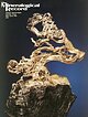 | | Journal (issue) | | Cooper Nottingham, England Anthony R. Kampf L.A. County Mus. of Nat. Hist. Los Angeles, CA Joseph A. Mandarino...Union mine lies in northwestern Arizona in Mohave County about 10 miles north of Kingman and 95 miles southeast...the 1860’s through the 1880’s, even serving as county seat from 1871 to 1873. However, by the early 1900’s...Wallapai mining district, Cerbat Moun tains, Mohave County, Arizona. U.S. Geological Survey Bulletin 978-E...zinc-lead mines in the Wallapai mining district, Mohave County, Arizona. U.S. Bureau o f M ines Report o f Investigations |  | | Journal (article/letter/editorial) | | images for identification, such as MacKenzie and Guilford (1980). Although the last of these makes understanding...textbooks. The final example is tourmaline, variety schorl, an accessory mineral not present in the knowledge...Book Co., New York, 492 p. MacKenzie, W. S., and Guilford, C., 1980, Atlas of rockforming minerals in thin... 119 Specimen "Opinion"for Tourmaline Variety Schorl (not Included in Knowledge Base) 18 answers from |  | | Book (volume) | | Duane L. Leavitt The Bennett Pegmatite, Oxford County, Maine . ........................................permanent photographic exhibits in the northeastern USA. The Shaubs have been active in ornithological research...tourmalinebearing Himalaya pegmatite at Mesa Grande, San Diego County, California. Most recently, Gene was gratified...Maine's treasure chest; Gems and minerals of Oxford County, second edition: Quicksilver Publications, West...California Ted Grant, Bnmswick, Maine Bill Gray, Windham, Maine Cliff Gray, Dover-Foxcroft, Maine Effe Gray |  | | Book (edition) | | diluvium, Peculiarities in the Diluvium of Berkshire County, Second Proof (diluvial grooves,) of a southerly...been greatly aided by the geological map of that county, published a few years since by Professor Dewey...Diluvial tracts of considerable extent exist in the county of Nor- Connecticut valley, and along the western...soil lying above this rock. The range Worcester county, is almost every where overspread with dilu- being...agricultural point of view. In the west pa^t of Worcester county, the soil, for a width of several miles across |  | | Book | | commercial ores and secondary minerals by state, county, township, and geologic range. For easy identification...cities, and many of today’s prosperous western county seats began as mining-boom camps. trating sand...Whether you such as those listed alphabetically by county, township, and range in Part II of this book. Where...will help you prospect and explore any state and county. etc., for mineral deposits in Finding Suitable...detailed reports on special areas, according to county. The bibliography of the United States Geological |  | | Book (edition) | | and Minerals Third Edition Garret Romaine GUILFORD, CONNECTICUT To my uncle Doug, who never turned...the United States; other agencies, such as state, county, and wildlife agencies, also control minor lands...Pegmatite features large crystals of feldspar, mica, schorl, and other minerals. PHOTO COURTESY OF THE RICE...commercial quarries in the Slate Valley of New York and Vermont produce very high-quality material. Experts also...found in the Llewellyn Formation of Schuylkill County, Pennsylvania PHOTO COURTESY OF THE RICE NORTHWEST |  | | Report (issue) | | ^ Anne Arundel County 43 Baltimore County 45 Howard County - Montgomery County 88 Prince Georges...Georges County Virginia 74 . 120 129 Arlington County 129 Fairfax County 131 Fauquier County 139...139 Loudoun County 143 Prince William County 149 Diabase quarries of northern Virginia 155 CAPTIONS...mines in the Soldiers Delight region, Baltimore County, Maryland. Adapted from Pearre and Heyl , 19.60...barrens of the Soldiers Delight region, Baltimore County, Maryland. Figure 11. Water-filled adit of the |  | | Journal (issue) | | Tuolumne County; 3.18 cm (36) Tuolumne County; 2.54 cm, 1.9 cm (39) Seaton mine, Amador County; 12.07 cm...Dorado County; 1.5 cm (55) Grit mine, El Dorado County; 8.26 cm (60) Grit mine, El Dorado County; 4.76...Dorado County; 4.29 cm (62) Grit mine, El Dorado County; 2.22 cm (63) Grit mine, El Dorado County; 2.54...WEW Figure 3. Gold from the Grit mine, El Dorado County, California: shown on the facing page as no. 60... Figure 4. Gold from the Grit mine, El Dorado County, California: the same specimen as no. 61 on Plate |  | | Journal (issue) | | Alves Mineralogy of the Bennett pegmatite, Oxford County, Maine ........................................../# 6 C alifornia Issue B enitoite, G old, L .A . County M useum , H im alaya m ine $7 Circulation Manager...on some crystals of ferrocolumbite. Elbaite and Schorl N a(Li,A l)3Al6(B 0 3)3Si60 18(0 H )4 and NaFe2+Al6(B...oriented) occurs in biotite, muscovite and magnetite. Schorl crystals, in some cases fibrous, are uncommon,...hematite, hydrothermalized albite, dark quartz and schorl. Locally it is found sprinkled with delicate hematite |  | | Journal (issue) | | Cooper Nottingham, England Anthony R. Kampf L.A. County Mus. of Nat. Hist. Los Angeles, CA Joseph A. Mandarino...Publishing P.O. Box 37072 Tucson, Arizona 85740 USA Tel: (520) 798-1513/(520) 297-4862 FAX: (520) 79...from Langesundfjord (southern Norway) and Colorado (USA). parts of the USSR to mine or buy material to sell...3 cm in matrix; and a Pelican mine, Clear Creek County acanthite such as would make Guanajuato or Freiberg...found at a so-far unspecified place in Fall River County, South Dakota. The lime stone matrix for these |  | | Book (volume) | | ..........................................400 Vermont..................................................rights, so remember you were told. If in doubt, a county map will tell you who the legal owner is. Good...gemmy qualities for cutting and polishing. AUTAUGA COUNTY PRATTVILLE, N. 6 mi., and just E of the Birmingham...were well known to prehistoric Indians.) BARBOUR COUNTY BAKER HILL, SE 1 mi. : 1 in a deep ravine, as a...deep red to variegated⎯ocher. BIBB COUNTY GENERAL AREA: c county gravel pits along the Cahaba R.⎯gemmy |
|


