| Locality type: | Mine |
| Classification |
|---|
|
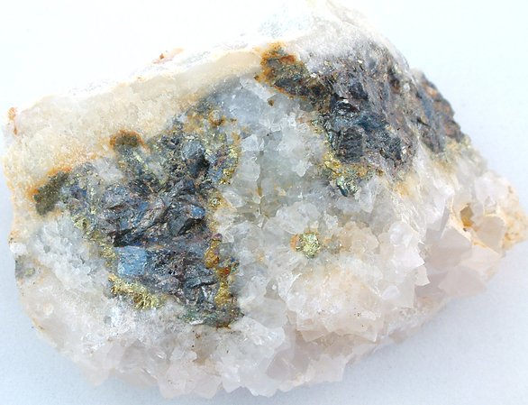
| Species: | Sphalerite |
| Formula: | ZnS |
| Confirmation |
|---|
|
| Validity: | Believed Valid |
| Associated Minerals Based on Photo Data: |
|---|
|
| Pyrite | ⓘ1 photo of Sphalerite associated with Pyrite at this locality. |
| Fluorite | ⓘ1 photo of Sphalerite associated with Fluorite at this locality. |
| Data |
|---|
|
| Mineral Data: | Click here to view Sphalerite data |
| Locality Data: | Click here to view Furzehill Mine (East Tamar Mine; incl. Whitsam Down Mine), East Tamar Consols, Bere Alston Mines, Bere Ferrers, West Devon, Devon, England, UK |
| Data Identifiers |
|---|
|
| Mindat Occurrence Record ID: | 275970 |
| Long-form Identifier: | 1:3:275970:8 |
| GUID (UUID V4): | 50ad7270-0feb-4760-991e-c216cb6b4693 |
| Nearest other occurrences of Sphalerite |
|---|
|
|
| 0.9km (0.6 miles) | ⓘSouth Tamar Consols (South Tamar Mine; Cowes Mine; incl. Cleave Mine; Birch Mine), Bere Alston Mines, Bere Ferrers, West Devon, Devon, England, UK |
| 1.0km (0.6 miles) | ⓘLockridge Mine (Goldstreet Mine), East Tamar Consols, Bere Alston Mines, Bere Ferrers, West Devon, Devon, England, UK |
| 1.3km (0.8 miles) | ⓘNorth Hooe Mine, Tamar Consols (Tamar Mines), Bere Alston Mines, Bere Ferrers, West Devon, Devon, England, UK |
| 2.7km (1.7 miles) | ⓘWheal Tamar, Landulph, Cornwall, England, UK |
| 3.6km (2.2 miles) | ⓘOkel Tor Mine, Harewood, Calstock, Cornwall, England, UK |
| 3.9km (2.4 miles) | ⓘLopwell Mine, Blindwell Wood, Buckland Monachorum, West Devon, Devon, England, UK |
| 4.7km (2.9 miles) | ⓘWheal Arthur (Wheal Phoenix; Slime Veor Mine), Drakewalls, Calstock, Cornwall, England, UK |
| 4.9km (3.0 miles) | ⓘLady Bertha Mine, Buckland Monachorum, West Devon, Devon, England, UK |
| 6.3km (3.9 miles) | ⓘWheal Brothers (Wheal Duchy), East Cornwall Silver Mines (St Vincent Great Consols; incl. Wheal Emily; Wheal Georgiana; Wheal Mercer), Wheal Langford (New Wheal Langford; Baring and Langford Mine), Calstock, Cornwall, England, UK |
| 6.6km (4.1 miles) | ⓘNew East Wheal Russell (South Wheal Crebor), Gulworthy, West Devon, Devon, England, UK |
| References |
|---|
|
|


Furzehill Mine, East Tamar Consols, Bere Alston Mines, Bere Ferrers, West Devon, Devon, England, UK