 | | Report (volume) | | Levias-Keystone and Dike-Eaton Areas Crittenden County, Kentucky GEOLOGICAL SURVEY BULLETIN 1122-E...Levias-Keystone and Dike-Eaton Areas Crittenden County, Kentucky By ROBERT D. TRACE CONTRIBUTIONS TO...-___--_-___----_--_-__-____--__----_____ Old Standard mine area________-___________--_________-_-_LaRue Brothers...Map of part of Keystone mine and Chipps shaft. Map and sections of Gilless mine. Section of Mississippian...LEVIAS-KEYSTONE AND DIKE-BATON AREAS, CRITTENDEN COUNTY, KENTUCKY By EGBERT D. TRACE ABSTRACT The fault |  | | Journal (article/letter/editorial) | | Kentucky Kentucky Mineral Mineral Locality Index Downloaded by [Dalhousie University] at 18:01 27 December...Caldwell Stone Company quarry, Danville, Boyle County. Terry Huizing specimen and photo. K entucky...Commonwealth is Black Mountain in the Appalachians (Harlan County) at 4,139 feet. The lowest point is the floor of...quarry near Grand Rivers (Livingston County) in western Kentucky, at 100 feet below sea level. There are...kimberlite in Elliott County in eastern Kentucky and alnöite intrusions in Crittenden and Livingston counties |  | | Journal (issue) | | Cooper Nottingham, England Anthony R. Kampf L.A, County Mus. of Nat. Hist. Los Angeles, CA Steven R. Morehead...January-February 1997 Volume Twenty-eight, Number One Hlmois-Kentucky Fluorite District Correspondents Miguel Calvo...group, 13 cm, w ith calcite from the Minerva No. 1 mine, near Cave in Rock, Illinois. Marvin Rausch collection;...Sterling mine at Antwerp, New York; the Alpine veins near Sherbrooke, Quebec; the Nanisivik mine on Baffin...country and soon became a collector. The cobalt mine at Bou-Azzer was among his favorite localities, |  | | Journal (issue) | | commemorate the recent history of the Illinois-Kentucky fluorspar district. I had wanted to hold this...quartz, Midstate Quarry, Magnet Cove, Hot Spring County, Arkansas. 2 Mineral News The 9th Maine Mineral...fluorite mine, Westmoreland, New Hampshire. The Rocks and Minerals article (Vol. 65) on the mine does not...specimens on display dispelled any doubts. The Wise Mine fluorite and quartz matrix specimens on display...discussed the mining and pocket discoveries at the Berry Mine, in the southern half of the Berry-Havey pegmatite |  | | Journal (article/letter/editorial) | | smithsonite, and the intense yellow of cadmian (or greenockite-included) smithsonite. Smithsonite pseudomorphs...depth. These include the Loudville mines, Hampshire County, Massachusetts; the Buckwheat pit, Franklin, New...Chester County, the Ueberroth mine near Bethlehem, and the zinc mines at Friedensville, Lehigh County, Pennsylvania;...Shenandoah Counties, and the Austinville district, Wythe County, Virginia; and the zinc occurrences in Claiborne...reflecting a significant cadmium content or included greenockite (“turkey fat ore”), have been found in brecciated |  | | Book | | Le WU aa, Lay nibs 7|| ¥ —& Loe sh Kentucky Geological Survey WILLARD ROUSE JILLSON DIRECTOR...SERIES VoLUME SIX THIRTEEN Fluorspar Deposits of Kentucky 1923 UIA AsuUITyO Iedsanoy ‘ouTUT s9d.IO;...AG *M ‘HY NOSTIIF ~ FLUORSPAR DEPOSITS of KENTUCKY A description and interpretation of the geologic...geologic occurrence and industrial importance of Kentucky F luorspar BY Louts WADE ASSISTANT CURRIER...Copies THE KENTUCKY GEOLOGICAL SURVEY FRANKFoRT, Ky. 1923 Copyrighted 1923 for THE KENTUCKY GEOLOGICAL | 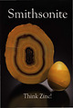 | | Report (issue) | | Smithsonite slice and egg, 5.8 and 2.7 cm tall Masua Mine, Carbonia-lglesias, Sardinia, Italy Cal and Kerith...cm wide 400 Foot Level, Kelly Mine, Magdalena District Socorro County, New Mexico Steve Neely collection...978-0-9790998-6-1 Publisher Lithographie, LLC Denver, Colorado, USA Design and Layout Gloria Staebler Gunther Neumeier...Lithographie, LLC P.O. Box 11613 • Denver, C O 80211 • USA Phone 1.303.495.5521 • Fax 1.303.482.1238 www.lithographie...1867. ·thsonian Smithsonite First Oxide Zone, Tsu Mine, Tsumeb, Nami 10cm tall Brent Lockhart coll Joe |  | | Journal (issue) | | Articles Famous mineral localities: the Taewha mine, K orea...........................................COVER: WULFENITE with mimetitefrom the San Francisco mine near Magdalena, Sonora, Mexico. The large crystal...Himalaya mine, Mesa Grande, California Tourmaline Queen mine, Pala, California Pala Chief mine, Pala, California...Ledge mine, Washington, California Benitoite Gem mine, San Benito Co., California U.S. Borax mine, Boron...Peacock mine, Virgin Valley, Nevada Hale-Norcross mine, Virginia City, Nevada Copper Queen mine, Bisbee | | | Journal (issue) | | Articles Famous mineral localities: the Taewha mine, Korea ...........................................COVER: WULFENITE with mimetite from the San Francisco mine near Magdalena, Sonora, Mexico. The large crystal...Himalaya mine, Me a Grande, California Tourmaline Queen mine, Pala, California Pala Chief mine, Pala,...Ledge mine, Washington, California Benitoite Gem mine, San Benito Co., California U.S. Borax mine, Boron...Peacock mine, Virgin Valley. Nevada Hale-Norcross mine, Virginia City, Nevada Copper Queen mine, Bisbee |  | | Book | | 4 ‘ » deat oggrtniLhy fiih ors! ¥; The Kentucky Geological Survey “=| WILLARD ROUSE JILLSON! ...Geology: and Mineral Resources of Kentucky 1928 Western Kentucky Fluorite— Ca F, 2 Natural Size The... The GEOLOGY and MINERAL RESOURCES of KENTUCKY A Brief Description of the Physiography, Stratigraphy,...GEOLOGIST OF KENTUCKY, CURATOR OF THE STATE MUSEUM AND LECTURER IN GEOLOGY AT THE UNIVERSITY OF KENTUCKY Illustrated...Fifty-one Photographs, Maps and Diagrams THE KENTUCKY GEOLOGICAL FRANKFORT, 1928 KY. SURVEY FIRST | 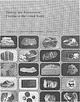 | Van Alstine, R. E., Worl, R.G., Heyl, A.V., Trace, R.D., Parker, R.L., Griffitts, W.R., Sainsbury, C.L., Cathcart, J.B. (1976) Geology and resources of fluorine in the United States. Professional Paper 933. US Geological Survey doi:10.3133/pp933 | Report (issue) | | 1. 2. 3. 4. 5. A sbestos ore Lead ore, Balmat mine, N . Y. Chromite-chromium ore, Washington Zinc ore...not yet discovered or not currently profitable to mine. The mining of mineral deposits, once they are discovered...Illinois-Kentucky ............................................................... . Illinois-Kentucky fluorspar...Central Kentucky ........................................................ . Cumberland River, Kentucky ........................................ . Cheshire County-Westmoreland, New Hampshire .... . North Chatham |  | | Journal (issue) | | result, the Franklin Hospital, first in Sussex County, was opened by the New Jersey Zinc Company in 1908...been now found in a second occurrence at the Kombat mine in Namibia. At that locality, it occurs as dark...b) Ogdensburgite has now been found in the Ojuela Mine, Mapimi, Durango, Mexico, associated with adamite...recently formed white crusts on timbers in the Max mine, Bleiberg, Carinthia, Austria. See Gerhard Niedermayr's...GLAUCOCHROITE -1899 GOETHITE GOLD GOLDMANITE GRAPHITE GREENOCKITE GROSSULAR GROUTITE GROVESITE GUERINITE GYPSUM |  | | Journal (issue) | | Famous mineral localities: the Home Sweet Home mine ..................................................quartz, 10 cm tall, from the Yucca Hill claim, Park County, Colorado. Richard A. Kosnar specimen; photo by...significant mineral localities in C o l o r a d o ,by county. In addition, there is a complete listing o f all...type localities, and an alphabetical cross-index by mine name. T INTRODUCTION In the Spring of 1976 a group...invited. COLORADO LOCALITY INDEX BOULDER COUNTY Caribou Mine Caribou (near Nederland), Caribou District |  | | Book (volume) | | ..........................................193 Kentucky ...............................................................548 Table of Maps Page Alabama County Map ...................................................................................4 Alaska County and Stream Map ......................................................................22 Arizona County Map ..................................................................45 Arizona – Yuma Co. Hull Mine Site Map ...................................... | 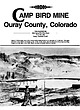 | | Journal (article/letter/editorial) | | AMP BIRD MINE Ouray County, Colorado TOM R O S E M E Y E R 1632 Camp Bird Mine Road P.O. Box 586 Ouray...courtesy Colorado Historical Society. The Camp Bird mine is one of Colorado's most famous gold mines and...the world's greatest gold producers. To date, the mine has produced almost 1.5 million ounces of gold along...Ouray to the mine follows Can yon Creek, becoming steep and precarious as it nears the mine. I n places...have lost their lives along the road to the mine and at the mine. The first rush of prospectors seeking gold | 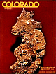 | | Journal (issue) | | had achieved considerable fame, and the right to mine diopside was obtained that year by G eorge L. English...thereafter. In 1971 both the land and the right to mine diopside were purchased by the present owners, Schuyler...Alveum, R obert Dow, and G eorge Robinson. T he mine is now being worked interm ittently each year for...encouraged, but can be done under perm it from the mine operators. Perm its may be obtained by first joining...MONSTER VARISCITE MINE by Peter I. Modreski Description T he Little G reen M onster mine is located in Clay |  | | Journal (issue) | | localities like the Sweet Horne mine, Breckenridge, Mount Antero, the Sunnyside mine, Creede, Cripple Creek,...By 1864 his expertise had brought him to Gilpin County, Colorado, where his reputation as a consultant...~ ) I~,. ~~ _ "f'• 0istrict, , ~ ,;:: V County , Colorado . l'fJ 1/ {r-zr--D '/;"~ of 2000...labels list the name of the lade or mine, the mining district and county, and the assay results for gold...breathless comments (excerpted from the Boulder County News) in 1878: Prof. J. Alden Smith, of tbis town | 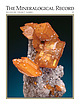 | | Journal (issue) | | Cooper Nottingham, England Anthony R. Kampf L.A. County Mus. of Nat. Hist. Los Angeles, CA Joseph A. Mandarino...crystal cluster on matrix, 6 cm tall, from the Tsumeb mine, Tsumeb, Namibia. Sandor Fuss collection (2004)...Vug,” discovered on the 12th level of the Cresson mine, Cripple Creek district, Colorado in 1914 (see “The...Mineralogical Record, volume 37, May–June, 2006 Cresson mine manager Dick Roelofs showing the Cresson Vug to...school; he did his Master’s work at the Rueppele iron mine in Stanton, Missouri. He spent the years 1931–1932 |  | | Book | | enter must be obtained to prevent trespass. Old mine workings are dangerous and entering underground...oFtne ato aa Gem Ghd nQkTeane Uva a nes ly ia" mine Ui nrobs inesob cere ts ou ioe tok us 'aaieomolitt...exception of the rhodochrosites of the Sweet Home Mine, Alma, Colorado, which were loaned for photography...Rita Area and the Central Mining District, Grant County Burro Mountains Apache No, 2 District Lake Valley...section of Upper Arkansas Valley near Leadville, Lake County, Colorado. Adapted from U.S.G.S., P.P. 726-c, 1972 |  | | Report (volume) | | described. Div. Mines, 1; Jenkins, O. P., Choctaw County, Highway 17 area: 3. Toulmin, L. D., Jr., 3. Minor:...analysis: KelH. D., 5. ler, W. D., 3. Talladega County, hematiteOklahoma, potash agstone, granite magnetite...ground water: Powham, C. E. ell, W. J., 4. Marengo County: Newton, J. G., 1. Core-drilling program, ChattanooMica:...J.,4. Excursion, Tertiary type-localiMontgomery County: Reade, ties: Rainwater, E. H. , 1. H. L. , Jr...Harris, H. B. trolled: Braunstein, J., 3. Escambia County: Cagle, J. W. ,Jr. Pollard field: Jones, W. B. |  | | Journal (issue) | | EDITORIAL COVER PHOTO: Bayldonite. Penberthy Croft mine, St. Hilary, Cornwall. Globular aggregates to 0...Simon Camm· Michael Merry ------- 16 ------THE VAN MINE S.J.S. Hughes -------26 ------A JOURNEY THROUGH... MINERAL NOTES SIEGENITE FROM ERGLODD MINE, TALYBONT, DYFED, WALES RGLODD Mine is located 200 metres east of...3. Mine subsidence and shaft collapse have demanded a programme co locate and stabilize old mine shafts...found has been published. 2. Lead levels in the mine spoil are above acceptable EEC limits. High lead |  | | Report (volume) | | depth__________ Precipitates from mine waters under superficial conditions_ Composition of mine waters of the Jopliu-region___________...Copperopolis, California____________________ 233 Shasta County, California______ _ __ 234 Snowstorm lode, Coeur...______ 236 239 239 239 240 240 240 Queen of Bronze mine, Oregon_________ Boundary district, British Columbia...Vancouver, British Columbia______ _ _ La Reforma mine, Campo Morado, Mexico_____I___ 242 242 San Jose...Prince of Wales Island, Alaska ______ 245 Bonanza mine, Chitina copper belt, Alaska 246 Boleo, Lower |  | | Book (volume) | | ..........................................165 Kentucky ................................................rights, so remember you were told. If in doubt, a county map will tell you who the legal owner is. Good...gemmy qualities for cutting and polishing. AUTAUGA COUNTY PRATTVILLE, N. 6 mi., and just E of the Birmingham...were well known to prehistoric Indians.) BARBOUR COUNTY BAKER HILL, SE 1 mi. : 1 in a deep ravine, as a...deep red to variegated⎯ocher. BIBB COUNTY GENERAL AREA: c county gravel pits along the Cahaba R.⎯gemmy |  | | Book (volume) | | ..........................................165 Kentucky ................................................rights, so remember you were told. If in doubt, a county map will tell you who the legal owner is. Good...gemmy qualities for cutting and polishing. AUTAUGA COUNTY PRATTVILLE, N. 6 mi., and just E of the Birmingham...were well known to prehistoric Indians.) BARBOUR COUNTY BAKER HILL, SE 1 mi. : 1 in a deep ravine, as a...deep red to variegated⎯ocher. BIBB COUNTY GENERAL AREA: c county gravel pits along the Cahaba R.⎯gemmy |  | | Report (volume) | | recently found in the Tenmile district, Summit County. In his booklet, which today would be classed as...feldspar, and mica, occur in some form in every county in the State. Among mineralogists, Colorado is...mineral belt that extends southwestward from Boulder County to the southern limits of the San Juan Mountains... lefferson County, the contact-metamorphic minerals of Italian Mountain, Gunnison County and elsewhere...minerals in the alkalic rocks of Iron Hill, Gunnison County. Colorado pegmatite bodies, considered as a unit |
|


