| Locality | Latitude | Longitude | Distance | Bearing |
|---|
| Pitfodels quarry, Aberdeen City, Scotland, UK | 57° 7' 49" N | 2° 9' 48" W | 0.0km (0.0 miles) | |
| Rubislaw Quarry, Aberdeen City, Scotland, UK | 57° 8' 22" N | 2° 8' 49" W | 1.4km (0.9 miles) | |
| Torry, Aberdeen City, Scotland, UK | 57° 8' 11" N | 2° 4' 50" W | 5.0km (3.1 miles) | |
| Laverock Braes, Middleton Park, Aberdeen City, Scotland, UK | 57° 11' 26" N | 2° 7' 44" W | 7.0km (4.4 miles) | |
| Middleton Park, Aberdeen City, Scotland, UK | 57° 11' 28" N | 2° 7' 9" W | 7.3km (4.5 miles) | |
| Belhelvie, Aberdeenshire, Scotland, UK | 57° 14' 57" N | 2° 5' 19" W | 14.0km (8.7 miles) | |
| Balmedie Quarry, Belhelvie, Aberdeenshire, Scotland, UK | 57° 15' 13" N | 2° 5' 28" W | 14.4km (8.9 miles) | |
| Stonehaven, Aberdeenshire, Scotland, UK | 56° 57' 49" N | 2° 12' 33" W | 18.7km (11.6 miles) | |
| Inverurie, Aberdeenshire, Scotland, UK | 57° 17' 0" N | 2° 22' 26" W | 21.2km (13.2 miles) | |
| Banchory, Aberdeenshire, Scotland, UK | 57° 3' 13" N | 2° 29' 27" W | 21.5km (13.4 miles) | |
| Long Gallery, Aberdeenshire, Scotland, UK | 56° 56' 5" N | 2° 11' 53" W | 21.9km (13.6 miles) | |
| Upper Middleton, Chapel of Garioch, Inverurie, Aberdeenshire, Scotland, UK | 57° 17' 16" N | 2° 26' 57" W | 24.6km (15.3 miles) | |
| Bruxie Hill, Stonehaven, Aberdeenshire, Scotland, UK | 56° 54' 55" N | 2° 17' 20" W | 25.1km (15.6 miles) | |
| Catterline, Stonehaven, Aberdeenshire, Scotland, UK | 56° 53' 40" N | 2° 13' 4" W | 26.4km (16.4 miles) | |
| Barras Quarry (Cotbank Quarry), Bruxie Hill, Stonehaven, Aberdeenshire, Scotland, UK | 56° 54' 11" N | 2° 17' 32" W | 26.5km (16.4 miles) | |
| Ellon, Aberdeenshire, Scotland, UK | 57° 21' 52" N | 2° 4' 22" W | 26.6km (16.5 miles) | |
| Chapel of Garioch, Inverurie, Aberdeenshire, Scotland, UK | 57° 18' 18" N | 2° 28' 16" W | 26.8km (16.7 miles) | |
| Braidon Bay, Catterline, Stonehaven, Aberdeenshire, Scotland, UK | 56° 53' 6" N | 2° 12' 48" W | 27.4km (17.0 miles) | |
| Todhead Point, Catterline, Stonehaven, Aberdeenshire, Scotland, UK | 56° 53' 0" N | 2° 12' 48" W | 27.6km (17.2 miles) | |
| Pitcaple, Inverurie, Aberdeenshire, Scotland, UK | 57° 19' 12" N | 2° 27' 43" W | 27.7km (17.2 miles) | |
| Torphins, Banchory, Aberdeenshire, Scotland, UK | 57° 6' 18" N | 2° 37' 22" W | 27.9km (17.3 miles) | |
| Pitscurrie Quarry, Pitcaple, Inverurie, Aberdeenshire, Scotland, UK | 57° 19' 45" N | 2° 27' 8" W | 28.1km (17.5 miles) | |
| Craiglash Quarry, Torphins, Banchory, Aberdeenshire, Scotland, UK | 57° 4' 40" N | 2° 37' 30" W | 28.5km (17.7 miles) | |
| Kinneff, Stonehaven, Aberdeenshire, Scotland, UK | 56° 51' 51" N | 2° 14' 16" W | 29.9km (18.6 miles) | |
| Arbuthnott, Aberdeenshire, Scotland, UK | 56° 52' 9" N | 2° 19' 56" W | 30.8km (19.1 miles) | |
| Allardice, Arbuthnott, Aberdeenshire, Scotland, UK | 56° 51' 41" N | 2° 17' 49" W | 31.0km (19.2 miles) | |
| Bennachie, Inverurie, Aberdeenshire, Scotland, UK | 57° 18' 40" N | 2° 33' 47" W | 31.4km (19.5 miles) | |
| Don river bridge, Keig, Alford, Aberdeenshire, Scotland, UK | 57° 15' 25" N | 2° 38' 5" W | 31.7km (19.7 miles) | |
| Birness, Ellon, Aberdeenshire, Scotland, UK | 57° 24' 11" N | 1° 59' 34" W | 32.0km (19.9 miles) | |
| Keig, Alford, Aberdeenshire, Scotland, UK | 57° 15' 36" N | 2° 38' 37" W | 32.3km (20.1 miles) | |
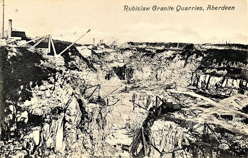
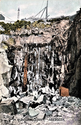


Rubislaw Quarry, Aberdeen City, Scotland, UK