Mysore corundum deposits, Karnataka, Indiai
| Regional Level Types | |
|---|---|
| Mysore corundum deposits | Mining Area |
| Karnataka | State |
| India | Country |
This page is currently not sponsored. Click here to sponsor this page.


Latitude & Longitude:
14° North , 76° East (est.)
Estimate based on other nearby localities or region boundaries.
Margin of Error:
~442km
Type:
Mindat Locality ID:
409441
Long-form identifier:
mindat:1:2:409441:1
GUID (UUID V4):
490beca5-dcf2-4ef8-9c70-d2abf1e0f0ae
Other/historical names associated with this locality:
Mysuru district; Carvatie ?; Mysore District
Located in the southern Karnatakan State, India.
"Many ruby specimens from India are simply labelled “Mysore”. This designation has historical significance but, unfortunately, little geographical precision. Mysore is the name of everything from a modern city to an ancient kingdom. (In 2014 the names of the city and associated administrative regions were changed from the anglicised “Mysore” back to the original “Mysuru”.) At the present time, Karnataka State has a Mysore District (6,854 sq. km) that sits within Mysore Division (43,400 sq. km.). (Before 1998 the district was twice as large and was then divided in two.) But unless the original Mysore specimen label includes “District” or “Division” there is no reason to assign these locations to the specimen. From 1799 until 1956 there was a Mysore princely state, cut from the remains of the former Kingdom of Mysore. In 1956 its territory was greatly expanded (including the present districts of Dakshina Kannada and Kodagu) and it became Mysore State, which was then renamed Karnataka State in 1973. The significance of “Mysore” on a label will depend on the history of the specimen and the motives of the seller. Specimens labelled before 1956 will probably refer to the territory of the princely state, or possibly to the former kingdom. After that, it is less certain. The primary reason for the uncertainty is that most of the ruby specimens come from clandestine sites and there is an effort to protect their identity by providing a historically accurate but geographically imprecise provenance. So any ruby simply labelled “Mysore” may in fact come from a wide range of locations in the state of Karnataka.
Older references to Mysore would include most of Karnataka.
Locality called 'Carvatie' possibly a misrecording of Karnataka
Select Mineral List Type
Standard Detailed Gallery Strunz Chemical ElementsDetailed Mineral List:
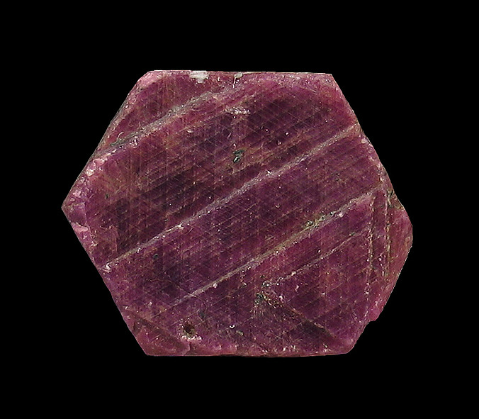
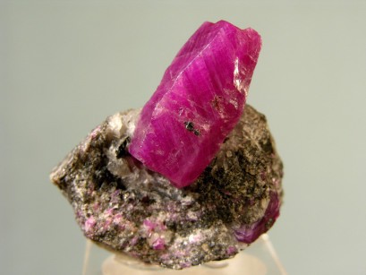
| ⓘ Corundum Formula: Al2O3 |
| ⓘ Corundum var. Ruby Formula: Al2O3 |

List of minerals arranged by Strunz 10th Edition classification
| Group 4 - Oxides and Hydroxides | |||
|---|---|---|---|
| ⓘ | Corundum | 4.CB.05 | Al2O3 |
| ⓘ | var. Ruby | 4.CB.05 | Al2O3 |
List of minerals for each chemical element
| O | Oxygen | |
|---|---|---|
| O | ⓘ Corundum | Al2O3 |
| O | ⓘ Corundum var. Ruby | Al2O3 |
| Al | Aluminium | |
| Al | ⓘ Corundum | Al2O3 |
| Al | ⓘ Corundum var. Ruby | Al2O3 |
This page contains all mineral locality references listed on mindat.org. This does not claim to be a complete list. If you know of more minerals from this site, please register so you can add to our database. This locality information is for reference purposes only. You should never attempt to
visit any sites listed in mindat.org without first ensuring that you have the permission of the land and/or mineral rights holders
for access and that you are aware of all safety precautions necessary.
Quick NavTopMineral List


Mysore corundum deposits, Karnataka, India