| Locality type: | Mine |
| Classification |
|---|
|
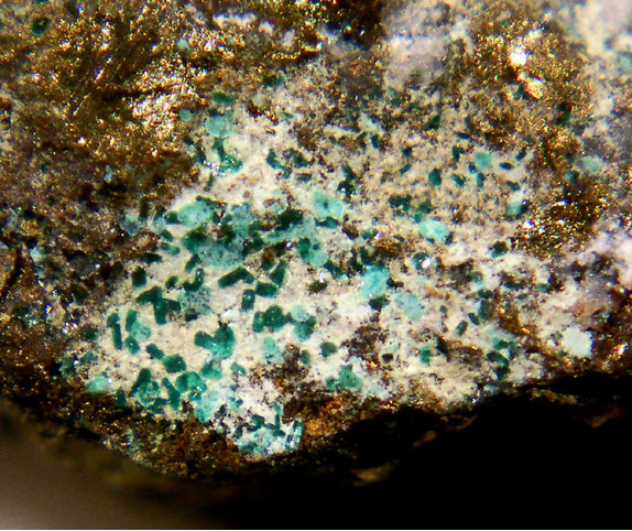
| Species: | Brochantite |
| Formula: | Cu4(SO4)(OH)6 |
| Confirmation |
|---|
|
| Validity: | Believed Valid |
| Associated Minerals Based on Photo Data: |
|---|
|
| Linarite | ⓘ2 photos of Brochantite associated with Linarite at this locality. |
| Chalcopyrite | ⓘ1 photo of Brochantite associated with Chalcopyrite at this locality. |
| Data |
|---|
|
| Mineral Data: | Click here to view Brochantite data |
| Locality Data: | Click here to view Tingherla Mine, Roveda, Frassilongo, Trento Province (Trentino), Trentino-Alto Adige (Trentino-South Tyrol), Italy |
| Photo Gallery | View Gallery (4 photos) |
| Data Identifiers |
|---|
|
| Mindat Occurrence Record ID: | 678886 |
| Long-form Identifier: | 1:3:678886:5 |
| GUID (UUID V4): | 693d257d-1b7f-44c0-a8fa-08b819b16927 |
| Nearest other occurrences of Brochantite |
|---|
|
|
| 2.5km (1.5 miles) | ⓘRio Ricet mine ("Rio Menegol"), Vignola-Falesina, Trento Province (Trentino), Trentino-Alto Adige (Trentino-South Tyrol), Italy |
| 2.8km (1.7 miles) | ⓘNo. 2 vein, Vignola Mine, Vignola-Falesina, Trento Province (Trentino), Trentino-Alto Adige (Trentino-South Tyrol), Italy |
| 3.4km (2.1 miles) | ⓘVignola Mine, Vignola-Falesina, Trento Province (Trentino), Trentino-Alto Adige (Trentino-South Tyrol), Italy |
| 3.9km (2.4 miles) | ⓘViarago Mine, Pergine Valsugana, Trento Province (Trentino), Trentino-Alto Adige (Trentino-South Tyrol), Italy |
| 5.6km (3.5 miles) | ⓘCinquevalli Mine, Roncegno Terme, Trento Province (Trentino), Trentino-Alto Adige (Trentino-South Tyrol), Italy |
| 7.8km (4.9 miles) | ⓘMaso Erdemolo (Grua va Hardimbl), Palù del Fersina, Trento Province (Trentino), Trentino-Alto Adige (Trentino-South Tyrol), Italy |
| 8.8km (5.5 miles) | ⓘNogaré Mines, Nogaré, Pergine Valsugana, Trento Province (Trentino), Trentino-Alto Adige (Trentino-South Tyrol), Italy |
| 9.1km (5.7 miles) | ⓘQuadrate, Fornace, Trento Province (Trentino), Trentino-Alto Adige (Trentino-South Tyrol), Italy |
| 9.4km (5.8 miles) | ⓘMonte Celva mine, Roncogno, Pergine Valsugana, Trento Province (Trentino), Trentino-Alto Adige (Trentino-South Tyrol), Italy |
| 28.2km (17.5 miles) | ⓘVal Gardena Sandstone exposure near San Lugano pass, Carano, Ville di Fiemme, Trento Province (Trentino), Trentino-Alto Adige (Trentino-South Tyrol), Italy |
| References |
|---|
|
Ferretti, P., Camin, C., Fassina, B., Gentile, P., Rocchetti, I., Vecchi, F. (2018) Miniera Tingherla (Frassilongo, Valle del Fersina). Aggiornamento di una località classica della mineralogia trentina. Rivista Mineralogica Italiana, 42, 2 (2-2018), 108-141. |
| Reference Search (possible matching items) |
|---|
 | | Book | | rocce vulcaniche del Padon. 2 Nel 1208ilvescovo trentino Federico Vanga raccolse in un codice chiamato...dei minerali sono le più antiche in Europa. Il Trentino deidinosauri MarcoAvanzii Nel corso degli ultimi...dinosauro carnivoro nel sito di Coste Anglone {Oro, Trento). A destra: ricerche nelle rocce dell'Anisico del...Marco, in Trentino e Altamura in Puglia. In questo quadro generale il Trentino Alto Adige rappresenta...circa 5 metri e pesante 230 kg. Monte Anglone, Dro, Trento. tiero decidiamo di tagliare in orizzontale la |  | | Book | | metals in Europe, the Middle East, South-west and South-east Asia, South America and Africa. Recently, Roberts...Ruiz and Ruíz Taboada 1996), and at Tal-i Iblis in south-east Iran at the first half of the fifth millennium...map is limited to the North African coast in the south, 12 with the exception of Egypt. This may be...decreases dramatically compared to the TEMB. In the south of Mesopotamia, there are no ore deposits either...Mesopotamia in the east across the desert margins south of the mountain ranges of eastern Anatolia to the |
|


Tingherla Mine, Roveda, Frassilongo, Trento Province, Trentino-Alto Adige, Italy