| Classification |
|---|
|
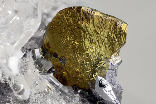
| Species: | Chalcopyrite |
| Formula: | CuFeS2 |
| Confirmation |
|---|
|
| Validity: | Believed Valid |
| Associated Minerals Based on Photo Data: |
|---|
|
| Sphalerite | ⓘ1 photo of Chalcopyrite associated with Sphalerite at this locality. |
| Data |
|---|
|
| Mineral Data: | Click here to view Chalcopyrite data |
| Locality Data: | Click here to view Arma di Taggia, Taggia, Imperia Province, Liguria, Italy |
| Photo Gallery | View Gallery (4 photos) |
| Data Identifiers |
|---|
|
| Mindat Occurrence Record ID: | 708654 |
| Long-form Identifier: | 1:3:708654:0 |
| GUID (UUID V4): | 7e74b79c-5be1-4ed9-8fe4-ac4d14d10847 |
| Nearest other occurrences of Chalcopyrite |
|---|
|
|
| 34.3km (21.3 miles) | ⓘTende Pb-Bi-S-Te occurrence (Les Chanels), Tende, Nice, Alpes-Maritimes, Provence-Alpes-Côte d'Azur, France |
| 37.9km (23.6 miles) | ⓘVallauria Mine, Tende, Nice, Alpes-Maritimes, Provence-Alpes-Côte d'Azur, France |
| 38.6km (24.0 miles) | ⓘZuccarello (Rian Gianco), Castelvecchio di Rocca Barbena, Savona Province, Liguria, Italy |
| 38.8km (24.1 miles) | ⓘColle Rousse outcrop, Tende, Nice, Alpes-Maritimes, Provence-Alpes-Côte d'Azur, France |
| 40.8km (25.3 miles) | ⓘCîme de Raus - east of, Capelet Mountain, Belvédère, Nice, Alpes-Maritimes, Provence-Alpes-Côte d'Azur, France |
| 44.1km (27.4 miles) | ⓘVallon des Graus, Capelet Mountain, Belvédère, Nice, Alpes-Maritimes, Provence-Alpes-Côte d'Azur, France |
| 45.9km (28.5 miles) | ⓘLa Gordolasque (EDF gallery), Capelet Mountain, Belvédère, Nice, Alpes-Maritimes, Provence-Alpes-Côte d'Azur, France |
| 48.1km (29.9 miles) | ⓘPagarì Refuge (Federici-Marchesini Refuge), Entracque, Cuneo Province, Piedmont, Italy |
| 48.4km (30.1 miles) | ⓘCasario - Bric delle Piombere, Casario, Priola, Cuneo Province, Piedmont, Italy |
| 48.7km (30.3 miles) | ⓘCorsaglia, Montaldo di Mondovì, Cuneo Province, Piedmont, Italy |
| References |
|---|
|
|


Arma di Taggia, Taggia, Imperia Province, Liguria, Italy