| Locality | Latitude | Longitude | Distance | Bearing |
|---|
| Viaredssjön, Borås, Västra Götaland County, Sweden | 57° 41' 28" N | 12° 48' 31" E | 3.1km (1.9 miles) | |
| Sandhult, Borås, Västra Götaland County, Sweden | 57° 46' 13" N | 12° 49' 20" E | 6.2km (3.8 miles) | |
| Ulvås mine, Svenljunga, Västra Götaland County, Sweden | 57° 23' 25" N | 13° 1' 51" E | 38.0km (23.6 miles) | |
| Gräne feldspar quarry, Överlida, Svenljunga, Västra Götaland County, Sweden | 57° 22' 29" N | 12° 54' 58" E | 38.2km (23.7 miles) | |
| Stackebo, Svenljunga, Västra Götaland County, Sweden | 57° 22' 45" N | 13° 1' 32" E | 39.1km (24.3 miles) | |
| Ytterlida pegmatite, Överlida, Svenljunga, Västra Götaland County, Sweden | 57° 20' 52" N | 12° 53' 7" E | 41.0km (25.5 miles) | |
| Skillnabo, Överlida, Svenljunga, Västra Götaland County, Sweden | 57° 21' 5" N | 12° 59' 57" E | 41.6km (25.9 miles) | |
| Bönabo, Nödinge, Ale, Västra Götaland County, Sweden | 57° 52' 17" N | 12° 5' 15" E | 47.6km (29.6 miles) | |
| Mossebo, Tranemo, Västra Götaland County, Sweden | 57° 26' 46" N | 13° 27' 52" E | 48.0km (29.8 miles) | |
| Rished pegmatite, Nödinge, Ale, Västra Götaland County, Sweden | 57° 55' 26" N | 12° 7' 1" E | 48.4km (30.1 miles) | |
| Fjärås, Kungsbacka, Halland County, Sweden | 57° 27' 36" N | 12° 10' 13" E | 48.7km (30.3 miles) | |
| Nödinge quarry, Nödinge, Ale, Västra Götaland County, Sweden | 57° 53' 11" N | 12° 3' 47" E | 49.5km (30.8 miles) | |
| Skårdal, Bohus, Ale, Västra Götaland County, Sweden | 57° 51' 1" N | 12° 1' 38" E | 50.2km (31.2 miles) | |
| Bohus, Ale, Västra Götaland County, Sweden | 57° 51' 5" N | 12° 1' 6" E | 50.7km (31.5 miles) | |
| Nol Quarry, Nödinge, Ale, Västra Götaland County, Sweden | 57° 54' 49" N | 12° 3' 43" E | 50.8km (31.6 miles) | |
| Nävshult quartz quarry, Mossebo, Tranemo, Västra Götaland County, Sweden | 57° 23' 42" N | 13° 26' 35" E | 50.8km (31.6 miles) | |
| Mölndal occurrence, Mölndal, Västra Götaland County, Sweden | 57° 38' 59" N | 11° 58' 0" E | 52.1km (32.4 miles) | |
| Ingelsbo pegmatite, Båraryd, Gislaved, Jönköping County, Sweden | 57° 24' 56" N | 13° 31' 39" E | 53.1km (33.0 miles) | |
| Högsbo quarries, Västra Frölunda, Gothenburg, Västra Götaland County, Sweden | 57° 39' 48" N | 11° 56' 44" E | 53.2km (33.0 miles) | |
| Lundbytunneln, Gothenburg, Västra Götaland County, Sweden | 57° 42' 44" N | 11° 54' 27" E | 55.1km (34.2 miles) | |
| Ingalsbo pegmatite, Båraryd, Gislaved, Jönköping County, Sweden | 57° 23' 6" N | 13° 31' 28" E | 55.1km (34.3 miles) | |
| Sprottebo quartz quarry, Båraryd, Gislaved, Jönköping County, Sweden | 57° 23' 25" N | 13° 33' 10" E | 56.0km (34.8 miles) | |
| Hagen, Gothenburg, Västra Götaland County, Sweden | 57° 40' 11" N | 11° 53' 21" E | 56.4km (35.1 miles) | |
| Slätteryd pegmatite, Båraryd, Gislaved, Jönköping County, Sweden | 57° 21' 48" N | 13° 33' 44" E | 58.4km (36.3 miles) | |
| Båraryd, Gislaved, Jönköping County, Sweden | 57° 19' 53" N | 13° 30' 18" E | 58.5km (36.4 miles) | |
| Björkelund, Båraryd, Gislaved, Jönköping County, Sweden | 57° 19' 29" N | 13° 32' 32" E | 60.6km (37.7 miles) | |
| Lilla Ammås, Ullared, Falkenberg, Halland County, Sweden | 57° 9' 18" N | 12° 43' 1" E | 62.7km (38.9 miles) | |
| Söingen quarry, Villstad, Gislaved, Jönköping County, Sweden | 57° 13' 13" N | 13° 23' 58" E | 64.5km (40.1 miles) | |
| Ullared, Falkenberg, Halland County, Sweden | 57° 8' 10" N | 12° 43' 5" E | 64.8km (40.2 miles) | |
| Derome pegmatites, Varberg, Halland County, Sweden | 57° 12' 28" N | 12° 17' 18" E | 65.2km (40.5 miles) | |
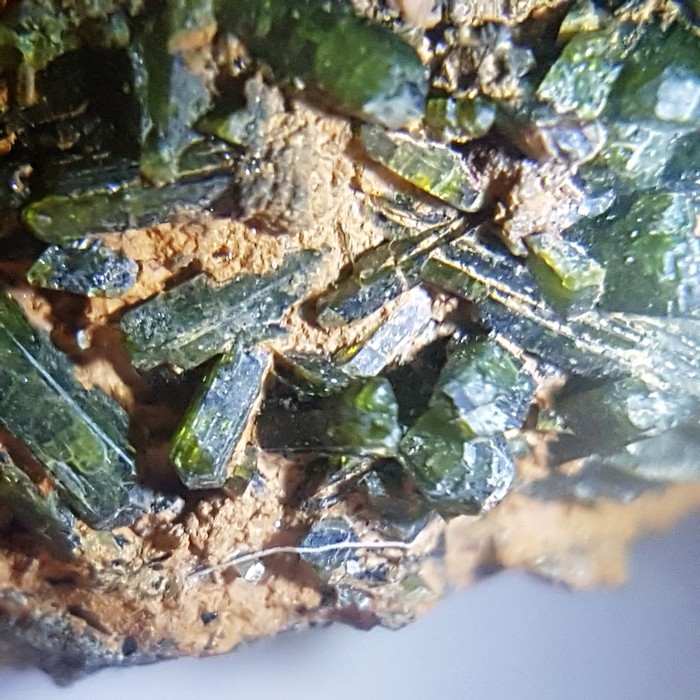


Viaredssjön, Borås, Västra Götaland County, Sweden