Rudzusalas Quarry, Jersika Parish, Līvāni Municipality, Latgale Region, Latviai
| Regional Level Types | |
|---|---|
| Rudzusalas Quarry | Quarry (Flooded) |
| Jersika Parish | Parish |
| Līvāni Municipality | Municipality |
| Latgale Region | Region |
| Latvia | Country |
This page is currently not sponsored. Click here to sponsor this page.


Latitude & Longitude (WGS84):
56° 18' 9'' North , 26° 15' 12'' East
Latitude & Longitude (decimal):
Type:
Quarry (Flooded) - last checked 2023
Deposit first discovered:
2011
Age:
382.7 ± 1.6 to 358.9 ± 0.4 Ma
Geologic Time:
Köppen climate type:
Mindat Locality ID:
436873
Long-form identifier:
mindat:1:2:436873:4
GUID (UUID V4):
5d22a687-491b-4f95-8e28-b6451c62e2e9
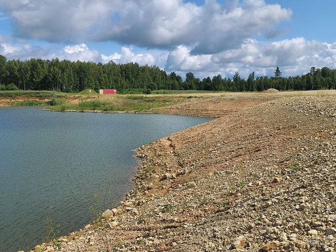
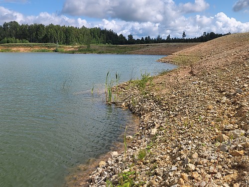
Rudzusalas Dolomite Quarry is a Late Devonian (Pļaviņu suite) dolomite deposit located in the Jersika Parish (Līvāni Municipality). It's a small and young quarry (currently flooded) for the extraction of crushed dolomite which is used for road chippings.
If one relies on data from the geological registry and satellite maps, can see that the quarry existed in the period from 2011 to 2016. After that, it was flooded. Now the quarry is a small reservoir, in some places of which one can see dolomite rock outcrops. Sometimes can find small pyrite concretions which have been oxidized in humid air, turning a reddish-brown colour.
Currently, only a small mound of rock is available in this quarry, in which one can find several white calcite specimens.
Select Mineral List Type
Standard Detailed Gallery Strunz Chemical ElementsDetailed Mineral List:
| ⓘ Calcite Formula: CaCO3 References: Dmitry Vorobjov's collectionIdentified by Dmitry Vorobyov (locality photos): Visual Identification |
Gallery:
List of minerals arranged by Strunz 10th Edition classification
| Group 5 - Nitrates and Carbonates | |||
|---|---|---|---|
| ⓘ | Calcite | 5.AB.05 | CaCO3 |
List of minerals for each chemical element
| C | Carbon | |
|---|---|---|
| C | ⓘ Calcite | CaCO3 |
| O | Oxygen | |
| O | ⓘ Calcite | CaCO3 |
| Ca | Calcium | |
| Ca | ⓘ Calcite | CaCO3 |
Other Regions, Features and Areas containing this locality
This page contains all mineral locality references listed on mindat.org. This does not claim to be a complete list. If you know of more minerals from this site, please register so you can add to our database. This locality information is for reference purposes only. You should never attempt to
visit any sites listed in mindat.org without first ensuring that you have the permission of the land and/or mineral rights holders
for access and that you are aware of all safety precautions necessary.


Rudzusalas Quarry, Jersika Parish, Līvāni Municipality, Latgale Region, Latvia