Eagle's Nest Mine (Mystery Wind Mine), Sage Hill, Michigan Bluff Mining District (Michigan Bluff Mining deposit), Placer County, California, USAi
This page kindly sponsored by David Mustart


Latitude & Longitude (WGS84):
39° 1' 24'' North , 120° 46' 32'' West
Latitude & Longitude (decimal):
Type:
Köppen climate type:
Nearest Settlements:
| Place | Population | Distance |
|---|---|---|
| Foresthill | 1,483 (2011) | 3.7km |
| Georgetown | 2,367 (2011) | 14.1km |
| Colfax | 2,005 (2017) | 17.5km |
| Auburn Lake Trails | 3,426 (2011) | 19.5km |
| Alta | 610 (2011) | 20.6km |
Nearest Clubs:
Local clubs are the best way to get access to collecting localities
Local clubs are the best way to get access to collecting localities
| Club | Location | Distance |
|---|---|---|
| El Dorado County Mineral and Gem Society | Placerville, California | 33km |
| Gold Country Treasure Seekers | Placerville, California | 33km |
| Nevada County Gem & Mineral Society | Grass Valley, California | 33km |
Mindat Locality ID:
5388
Long-form identifier:
mindat:1:2:5388:7
GUID (UUID V4):
8014a6b6-3b31-4547-bd38-25fe5c92562a
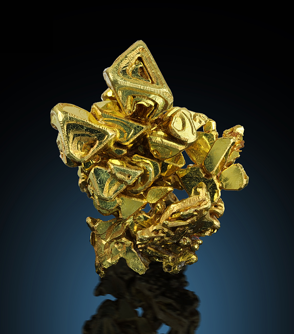
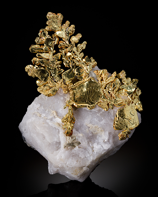
A lode Au occurrence/mine located in sec. 29 & in the SE¼ sec. 30, T14N, R11E, MDM, about 2.2 km SW of Sage Hill and about 8 km (4.8 miles) ENE of Foresthill, along Ladys Canyon, on French Meadow Road, on private land. The Eagle's Nest was a discovery pit at the top and some adits lower down in a five-level deposit of crystallized gold. The De Maria Mine is also on this deposit.
NOTE: Specifics regarding this mine's location are based on the data for the De Maria Mine at the lowest level of the same deposit.
The Mystery Wind Mine does not exist as a separate mine (Dona Leicht, pers. comm.) and was a made-up name used to conceal the origin of the specimens as was Eagle's Nest. (Wayne Leicht, pers. comm.) Both Mystery Wind and Eagle's Nest specimens are from the upper levels of the De Maria property and should be labelled Eagle's Nest as that was the published locality.
Select Mineral List Type
Standard Detailed Gallery Strunz Chemical ElementsDetailed Mineral List:
| ⓘ Dolomite Formula: CaMg(CO3)2 |
| ✪ Gold Formula: Au Habit: Small sharp octos to a cm, Dendrites, plates and wires to many cm Colour: gold Fluorescence: none Description: Crystal cluster with milky quartz, 8 inches Many of the pure gold "floaters" were leached from quartz References: |
| ⓘ Pyrite Formula: FeS2 |
| ⓘ Quartz Formula: SiO2 |

List of minerals arranged by Strunz 10th Edition classification
| Group 1 - Elements | |||
|---|---|---|---|
| ⓘ | Gold | 1.AA.05 | Au |
| Group 2 - Sulphides and Sulfosalts | |||
| ⓘ | Pyrite | 2.EB.05a | FeS2 |
| Group 4 - Oxides and Hydroxides | |||
| ⓘ | Quartz | 4.DA.05 | SiO2 |
| Group 5 - Nitrates and Carbonates | |||
| ⓘ | Dolomite | 5.AB.10 | CaMg(CO3)2 |
List of minerals for each chemical element
| C | Carbon | |
|---|---|---|
| C | ⓘ Dolomite | CaMg(CO3)2 |
| O | Oxygen | |
| O | ⓘ Dolomite | CaMg(CO3)2 |
| O | ⓘ Quartz | SiO2 |
| Mg | Magnesium | |
| Mg | ⓘ Dolomite | CaMg(CO3)2 |
| Si | Silicon | |
| Si | ⓘ Quartz | SiO2 |
| S | Sulfur | |
| S | ⓘ Pyrite | FeS2 |
| Ca | Calcium | |
| Ca | ⓘ Dolomite | CaMg(CO3)2 |
| Fe | Iron | |
| Fe | ⓘ Pyrite | FeS2 |
| Au | Gold | |
| Au | ⓘ Gold | Au |
Other Regions, Features and Areas containing this locality
This page contains all mineral locality references listed on mindat.org. This does not claim to be a complete list. If you know of more minerals from this site, please register so you can add to our database. This locality information is for reference purposes only. You should never attempt to
visit any sites listed in mindat.org without first ensuring that you have the permission of the land and/or mineral rights holders
for access and that you are aware of all safety precautions necessary.
References


Eagle's Nest Mine, Sage Hill, Michigan Bluff Mining District, Placer County, California, USA