| Locality | Latitude | Longitude | Distance | Bearing |
|---|
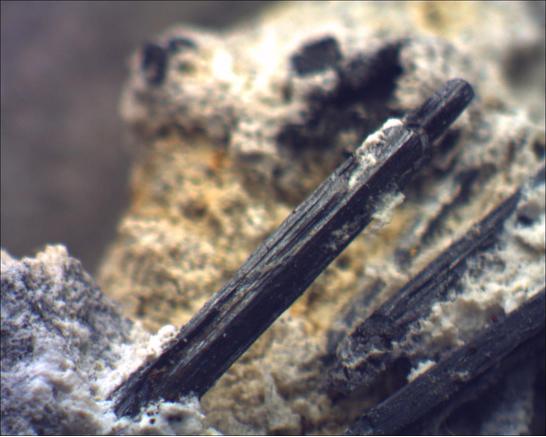
| Cienega Road Gypsum locality (Unspecified Gypsum occurrence of Pemberton), Ridgemark, San Benito County, California, USA | 36° 48' 20" N | 121° 24' 0" W | 0.0km (0.0 miles) | |
| Dr. J. M. O'Donnell deposit, Gabilan Range, San Benito County, California, USA | 36° 46' 50" N | 121° 24' 1" W | 2.8km (1.7 miles) | |
| Ridgemark, San Benito County, California, USA | 36° 48' 44" N | 121° 21' 56" W | 3.1km (2.0 miles) | |
| Middle Dam deposit (Middle Dam), Fremont Peak, Gabilan Range, San Benito County, California, USA | 36° 46' 37" N | 121° 26' 3" W | 4.4km (2.7 miles) | |
| A. S. and R. deposit (Crowe-Harris deposit), Fremont Peak, Gabilan Range, San Benito County, California, USA | 36° 46' 24" N | 121° 25' 48" W | 4.4km (2.8 miles) | |
| Crowe deposit, Fremont Peak, Gabilan Range, San Benito County, California, USA | 36° 46' 55" N | 121° 26' 48" W | 4.9km (3.0 miles) | |
| Hollister, San Benito County, California, USA | 36° 51' 8" N | 121° 24' 2" W | 5.2km (3.2 miles) | |
| Garner-Harris deposits, Gabilan Range, San Benito County, California, USA | 36° 45' 29" N | 121° 24' 33" W | 5.3km (3.3 miles) | |
| Reeves Northeast deposits, Gabilan Range, San Benito County, California, USA | 36° 45' 28" N | 121° 24' 24" W | 5.3km (3.3 miles) | |
| Harmony Hills deposit, Fremont Peak, Gabilan Range, San Benito County, California, USA | 36° 47' 27" N | 121° 27' 38" W | 5.6km (3.5 miles) | |
| Palmtag-Harris Ranch deposits, Gabilan Range, San Benito County, California, USA | 36° 45' 12" N | 121° 24' 6" W | 5.8km (3.6 miles) | |
| McCray Ranch deposits, Gabilan Range, San Benito County, California, USA | 36° 45' 11" N | 121° 24' 12" W | 5.8km (3.6 miles) | |
| Harris Ranch Quarry, Gabilan Range, San Benito County, California, USA | 36° 45' 10" N | 121° 23' 40" W | 5.9km (3.7 miles) | |
| Martin Ranch deposits, Gabilan Range, San Benito County, California, USA | 36° 45' 7" N | 121° 24' 32" W | 6.0km (3.7 miles) | |
| Pearce Quarry (Henry Cowell Lime & Cement Company; San Juan Canyon Quarry; Bryan and Pearce-Twohy deposits), Gabilan Range, San Benito County, California, USA | 36° 47' 22" N | 121° 28' 22" W | 6.7km (4.2 miles) | |
| Bird Canyon ledge, Gabilan Range, San Benito County, California, USA | 36° 45' 30" N | 121° 27' 14" W | 7.1km (4.4 miles) | |
| Tres Pinos, San Benito County, California, USA | 36° 47' 23" N | 121° 19' 15" W | 7.2km (4.5 miles) | |
| Hollister Dolomite Quarry (O'Hara Ranch; Westvaco), Gabilan Range, San Benito County, California, USA | 36° 44' 30" N | 121° 22' 54" W | 7.3km (4.5 miles) | |
| Upper Bird Creek deposit, Gabilan Range, San Benito County, California, USA | 36° 45' 23" N | 121° 27' 12" W | 7.3km (4.5 miles) | |
| Westvaco Mine, Gabilan Range, San Benito County, California, USA | 36° 44' 30" N | 121° 22' 58" W | 7.3km (4.5 miles) | |
| Unnamed Magnesite occurrence [1] (Unnamed Dolomite occurrence), Fremont Peak, Gabilan Range, San Benito County, California, USA | 36° 45' 20" N | 121° 27' 21" W | 7.5km (4.6 miles) | |
| Underwood deposits, Gabilan Range, San Benito County, California, USA | 36° 48' 6" N | 121° 29' 14" W | 7.8km (4.8 miles) | |
| Unnamed stone quarry (5), Gabilan Range, San Benito County, California, USA | 36° 47' 11" N | 121° 29' 57" W | 9.1km (5.6 miles) | |
| Power Line deposits, Gabilan Range, San Benito County, California, USA | 36° 44' 8" N | 121° 27' 17" W | 9.2km (5.7 miles) | |
| East Gabilan deposit, Natividad, Gabilan Range, Monterey County, California, USA | 36° 45' 24" N | 121° 29' 7" W | 9.3km (5.8 miles) | |
| Flint-Steinbeck deposit, Gabilan Range, San Benito County, California, USA | 36° 47' 12" N | 121° 30' 8" W | 9.4km (5.8 miles) | |
| Unnamed stone quarry (4), Gabilan Range, San Benito County, California, USA | 36° 47' 54" N | 121° 30' 25" W | 9.6km (6.0 miles) | |
| Riley Ranch, Chualar Canyon, Gabilan Range, Monterey County, California, USA | 36° 43' 47" N | 121° 20' 40" W | 9.7km (6.1 miles) | |
| Unnamed Cu-As occurrence [1] (Riley Ranch), Tres Pinos, San Benito County, California, USA | 36° 43' 47" N | 121° 20' 40" W | 9.7km (6.1 miles) | |
| Unnamed Baryte prospect (1), Fremont Peak, Gabilan Range, San Benito County, California, USA | 36° 45' 38" N | 121° 30' 2" W | 10.3km (6.4 miles) | |
Minerals recorded nearby (within 10.3 km)
Rock types recorded nearby (within 10.3 km)
Entries shown in red are rocks recorded for this region.


Hollister, San Benito County, California, USA