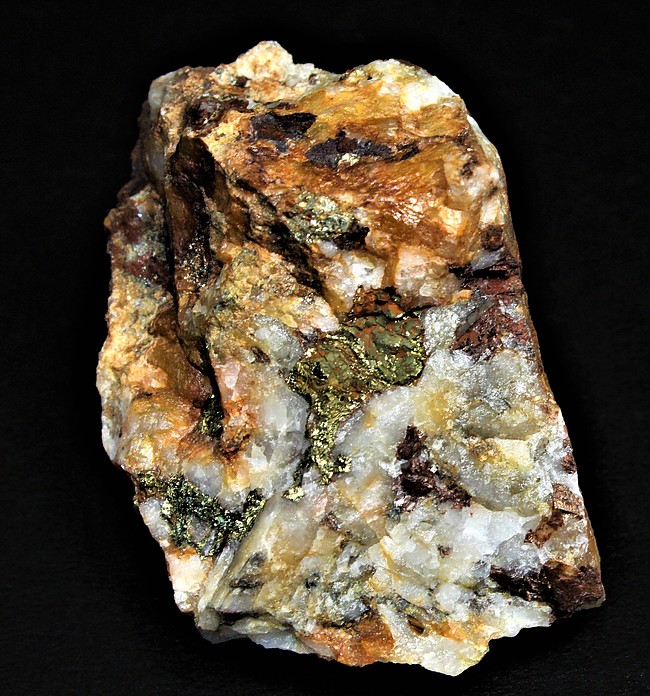
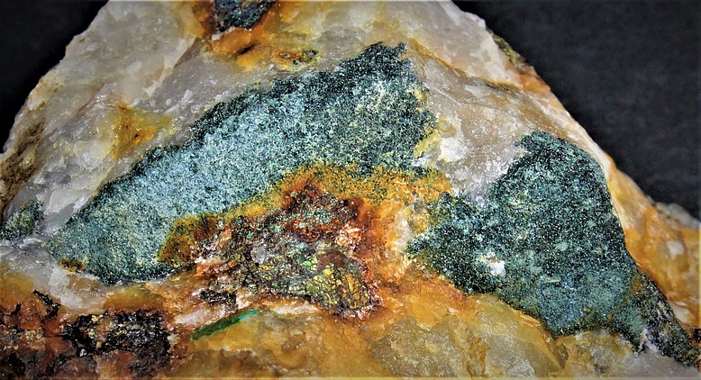
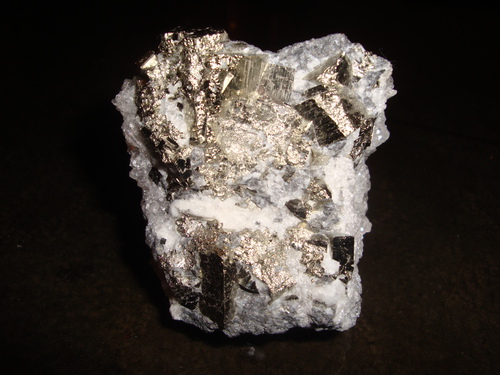
Gold-bearing Pyrite
A variety of Pyrite
This page is currently not sponsored. Click here to sponsor this page.


About Gold-bearing Pyrite
Formula:
FeS2
A variety of Pyrite
A gold-bearing variety of pyrite. Possibly a mixture of pyrite with submicroscopic native gold inclusions.
A gold-bearing variety of pyrite. Possibly a mixture of pyrite with submicroscopic native gold inclusions.
Unique Identifiers
Mindat ID:
424 (as Gold-bearing Pyrite)
3314 (as Pyrite)
3314 (as Pyrite)
Long-form identifier:
mindat:1:1:424:2 (as Gold-bearing Pyrite)
mindat:1:1:3314:1 (as Pyrite)
mindat:1:1:3314:1 (as Pyrite)
GUID
(UUID V4):
(UUID V4):
5afb7c35-031b-41aa-9aff-f632a627ef1b (as Gold-bearing Pyrite)
949ade6b-bc43-44c1-8073-49cb574bf3ef (as Pyrite)
949ade6b-bc43-44c1-8073-49cb574bf3ef (as Pyrite)
Chemistry of Gold-bearing Pyrite
Mindat Formula:
FeS2
Elements listed:
Synonyms of Gold-bearing Pyrite
Common Associates
Associated Minerals Based on Photo Data:
| 10 photos of Gold-bearing Pyrite associated with Quartz | SiO2 |
| 2 photos of Gold-bearing Pyrite associated with Hematite | Fe2O3 |
| 2 photos of Gold-bearing Pyrite associated with Siderite | FeCO3 |
| 1 photo of Gold-bearing Pyrite associated with Sericite | KAl2(AlSi3O10)(OH)2 |
| 1 photo of Gold-bearing Pyrite associated with Malachite | Cu2(CO3)(OH)2 |
| 1 photo of Gold-bearing Pyrite associated with Milky Quartz | SiO2 |
| 1 photo of Gold-bearing Pyrite associated with Limonite | |
| 1 photo of Gold-bearing Pyrite associated with Chalcopyrite | CuFeS2 |
Other Information
Health Risks:
No information on health risks for this material has been entered into the database. You should always treat mineral specimens with care.
Internet Links for Gold-bearing Pyrite
mindat.org URL:
https://www.mindat.org/min-424.html
Please feel free to link to this page.
Please feel free to link to this page.
Search Engines:
Mineral Dealers:
References for Gold-bearing Pyrite
Localities for Gold-bearing Pyrite
 symbol to view information about a locality.
The
symbol to view information about a locality.
The Locality List
 - This locality has map coordinates listed.
- This locality has estimated coordinates.
ⓘ - Click for references and further information on this occurrence.
? - Indicates mineral may be doubtful at this locality.
- This locality has map coordinates listed.
- This locality has estimated coordinates.
ⓘ - Click for references and further information on this occurrence.
? - Indicates mineral may be doubtful at this locality.
 - Good crystals or important locality for species.
 - World class for species or very significant.
(TL) - Type Locality for a valid mineral species.
(FRL) - First Recorded Locality for everything else (eg varieties).
- World class for species or very significant.
(TL) - Type Locality for a valid mineral species.
(FRL) - First Recorded Locality for everything else (eg varieties).
All localities listed without proper references should be considered as questionable.
Argentina | |
| Raúl Jorge Tauber Larry´collection. |
| Arizmendi (1996) |
| Raúl Jorge Tauber Larry | |
| |
Bolivia | |
| Osvaldo R. Arce Burgoa (2007) |
| Osvaldo R. Arce Burgoa (2007) |
| Arce Burgoa |
China | |
| Gritsenko et al. (2022) |
| Ma et al. (2022) | |
| Gritsenko et al. (2022) | |
| Gritsenko et al. (2022) |
| Wei et al. (2022) +1 other reference |
| Li et al. (2023) |
| Liu et al. (2018) |
| Wang |
| Guangbin Zhu et al. (2005) |
| Liu et al. (2022) |
| Liu et al. (2022) |
| Dai et al. (2022) +1 other reference |
| Yanqiu Zhao et al. (2005) |
| Zhao et al. (2022) |
| Li et al. (2022) |
| Yang et al. (2022) |
| Zhang et al. (2024) |
| Xu et al. (2023) | |
| Ding et al. (2022) |
| Xiao et al. (2022) |
| An et al. (2022) |
Indonesia | |
| King et al. (2014) |
| King et al. (2014) | |
Iran | |
| Lu et al. (2022) |
Mali | |
| Soro (2019) |
Poland | |
| Lis et al. (1986) |
Russia | |
| Kudrin et al. (2021) |
Tanzania | |
| Van Ryt et al. (2017) |
| Sanislav et al. (2015) | |
USA | |
| - (2008) |
| - (2008) |
| - (2008) | |
| Arizona Bureau of Mines files. +4 other references |
| MRDS database Dep. ID file #10282496 |
| Keith (1973) +1 other reference |
| Keith (1973) |
| Wilson (1934) +1 other reference | |
| Drewes et al. (1988) |
| Drewes et al. (1988) | |
| Keith (1973) +1 other reference |
| Wilson et al. (1934) |
| Wilson et al. (1934) |
| Keith (1978) +1 other reference |
| Ref.: Keith (1978) +1 other reference | |
| Jones et al. (1915) +1 other reference | |
| Ref.: Keith (1978) +1 other reference | |
| Keith (1978) +1 other reference |
| Keith (1978) | |
| Dale (1959) +2 other references |
| Keith (1978) | |
| Wilson (1941) +2 other references |
| AZ Bur. of Mines Bull. 135 (1933) |
| Garrett (1938) |
| Keith (1974) +1 other reference |
| Wilson (1934) +2 other references |
| Keith (1974) +1 other reference |
| Wilson (1934) |
| Anderson (1958) |
| Lindgren (1926) +1 other reference |
| Wilson et al. (1934) +1 other reference |
| - (2005) |
| - (2005) |
| - (2005) | |
| - (2005) |
| - (2005) |
| - (2005) |
| - (2005) | |
| - (2005) |
| - (2005) |
| - (2005) |
| - (2005) |
| - (2005) |
| - (2005) |
| - (2005) |
| Shepard (1858) |
| 346-347. +1 other reference |
| Ref: Montana Bureau of Mines and Gology ... |
| The Ore Deposits of The United States ... | |
| Ref: Montana Bureau of Mines and Gology ... | |
| Ref: Montana Bureau of Mines and Gology ... | |
| Ref: Montana Bureau of Mines and Gology ... |
| Ref: Montana Bureau of Mines and Gology ... | |
| Ref: Montana Bureau of Mines and Gology ... | |
| Ref: Montana Bureau of Mines and Gology ... |
| Winchell (1914) |
| Mines and Mineral Deposits of the ... +1 other reference |
| Mines and Mineral Deposits of the ... +1 other reference | |
| Koschmann et al. (1968) |
| Winchell (1914) | |
| Winchell (1914) |
| Koschmann et al. (1968) | |
| Winchell (1914) |
| Winchell (1914) |
| Winchell (1914) |
| Winchell (1914) | |
| Winchell (1914) | |
| Koschmann et al. (1968) |
| Fithian (2015) |
| David Von Bargen & Chester S. Lemanski |
| Cook (1868) +1 other reference |
| U.S Bureau of Mines (MAS/MILS) |
| Pogue et al. (1910) |
| Carpenter III (1976) |
| Carpenter III (1976) | |
| Carpenter III (1976) |
| Carpenter III (1976) |
| Carpenter III (1976) |
| Carpenter III (1976) |
| Carpenter III (1976) |
| Koschmann et al. (1968) |
| - (2005) |
| Loucks (1976) |


Gardner Hill Mine, Greensboro, Guilford County, North Carolina, USA