Gøtuvegur Roadcut, Skipanes, Eysturoy Island, Eysturoy Region, Faroe Islandsi
| Regional Level Types | |
|---|---|
| Gøtuvegur Roadcut | Road Cutting |
| Skipanes | Village |
| Eysturoy Island | Island |
| Eysturoy Region | Traditional Region |
| Faroe Islands | Autonomous Territory |
This page is currently not sponsored. Click here to sponsor this page.


Latitude & Longitude (WGS84):
62° 10' 29'' North , 6° 46' 2'' West
Latitude & Longitude (decimal):
Type:
Köppen climate type:
Nearest Settlements:
| Place | Population | Distance |
|---|---|---|
| Syðrugøta | 421 (2012) | 1.3km |
| Søldarfjørður | 360 (2018) | 1.5km |
| Ytri Skáli | 621 (2018) | 2.0km |
| Norðragøta | 573 (2017) | 3.2km |
| Skálafjørður | 105 (2012) | 4.7km |
Mindat Locality ID:
312653
Long-form identifier:
mindat:1:2:312653:3
GUID (UUID V4):
c12326b9-17ea-42f2-ac5d-85d9ecec22a9
Other/historical names associated with this locality:
Road 10
Road cut and temporary quarry near pass between Skipanes and Syđrugøta.
Select Mineral List Type
Standard Detailed Gallery Strunz Chemical ElementsDetailed Mineral List:
| ⓘ 'Chabazite' References: |
| ⓘ 'Heulandite Subgroup' Formula: (Na/Ca/K)5-6[Al8-9 Si27-28 O72] · nH2O References: |
| ⓘ 'Stilbite Subgroup' Formula: M6-7[Al8-9Si27-28O72] · nH2O References: |
| ⓘ Thomsonite-Ca Formula: NaCa2[Al5Si5O20] · 6H2O References: |
Gallery:

List of minerals arranged by Strunz 10th Edition classification
| Group 9 - Silicates | |||
|---|---|---|---|
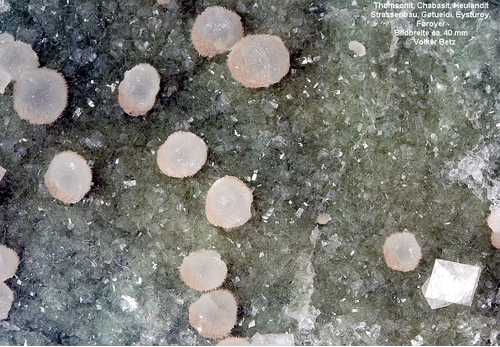
| ⓘ | Thomsonite-Ca | 9.GA.10 | NaCa2[Al5Si5O20] · 6H2O |
| Unclassified | |||
| ⓘ | 'Chabazite' | - | |
| ⓘ | 'Heulandite Subgroup' | - | (Na/Ca/K)5-6[Al8-9 Si27-28 O72] · nH2O |
| ⓘ | 'Stilbite Subgroup' | - | M6-7[Al8-9Si27-28O72] · nH2O |
List of minerals for each chemical element
| H | Hydrogen | |
|---|---|---|
| H | ⓘ Heulandite Subgroup | (Na/Ca/K)5-6[Al8-9 Si27-28 O72] · nH2O |
| H | ⓘ Stilbite Subgroup | M6-7[Al8-9Si27-28O72] · nH2O |
| H | ⓘ Thomsonite-Ca | NaCa2[Al5Si5O20] · 6H2O |
| O | Oxygen | |
| O | ⓘ Heulandite Subgroup | (Na/Ca/K)5-6[Al8-9 Si27-28 O72] · nH2O |
| O | ⓘ Stilbite Subgroup | M6-7[Al8-9Si27-28O72] · nH2O |
| O | ⓘ Thomsonite-Ca | NaCa2[Al5Si5O20] · 6H2O |
| Na | Sodium | |
| Na | ⓘ Heulandite Subgroup | (Na/Ca/K)5-6[Al8-9 Si27-28 O72] · nH2O |
| Na | ⓘ Thomsonite-Ca | NaCa2[Al5Si5O20] · 6H2O |
| Al | Aluminium | |
| Al | ⓘ Heulandite Subgroup | (Na/Ca/K)5-6[Al8-9 Si27-28 O72] · nH2O |
| Al | ⓘ Stilbite Subgroup | M6-7[Al8-9Si27-28O72] · nH2O |
| Al | ⓘ Thomsonite-Ca | NaCa2[Al5Si5O20] · 6H2O |
| Si | Silicon | |
| Si | ⓘ Heulandite Subgroup | (Na/Ca/K)5-6[Al8-9 Si27-28 O72] · nH2O |
| Si | ⓘ Stilbite Subgroup | M6-7[Al8-9Si27-28O72] · nH2O |
| Si | ⓘ Thomsonite-Ca | NaCa2[Al5Si5O20] · 6H2O |
| K | Potassium | |
| K | ⓘ Heulandite Subgroup | (Na/Ca/K)5-6[Al8-9 Si27-28 O72] · nH2O |
| Ca | Calcium | |
| Ca | ⓘ Heulandite Subgroup | (Na/Ca/K)5-6[Al8-9 Si27-28 O72] · nH2O |
| Ca | ⓘ Thomsonite-Ca | NaCa2[Al5Si5O20] · 6H2O |
Other Regions, Features and Areas containing this locality
Eurasian PlateTectonic Plate
EuropeContinent
Faroe Islands
- ⭔Eysturoy RegionTraditional Region
North Atlantic Igneous ProvinceLarge Igneous Province
This page contains all mineral locality references listed on mindat.org. This does not claim to be a complete list. If you know of more minerals from this site, please register so you can add to our database. This locality information is for reference purposes only. You should never attempt to
visit any sites listed in mindat.org without first ensuring that you have the permission of the land and/or mineral rights holders
for access and that you are aware of all safety precautions necessary.
References


Gøtuvegur Roadcut, Skipanes, Eysturoy Island, Eysturoy Region, Faroe Islands