| Locality type: | Quarry |
| Classification |
|---|
|
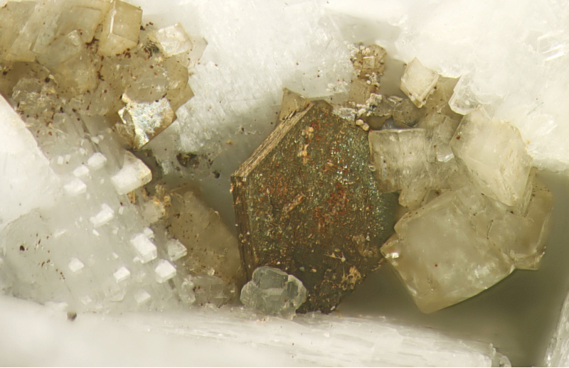
| Species: | Pyrrhotite |
| Formula: | Fe1-xS |
| Habit: | hexagonal plates, tabular |
| Colour: | bronzy yellow, metallic |
| Confirmation |
|---|
|
| Validity: | Believed Valid |
| Associated Minerals Based on Photo Data: |
|---|
|
| Calcite | ⓘ19 photos of Pyrrhotite associated with Calcite at this locality. |
| Strontianite | ⓘ7 photos of Pyrrhotite associated with Strontianite at this locality. |
| Pectolite | ⓘ5 photos of Pyrrhotite associated with Pectolite at this locality. |
| Siderite | ⓘ5 photos of Pyrrhotite associated with Siderite at this locality. |
| Diopside | ⓘ4 photos of Pyrrhotite associated with Diopside at this locality. |
| Annite | ⓘ3 photos of Pyrrhotite associated with Annite at this locality. |
| Hibschite | ⓘ3 photos of Pyrrhotite associated with Hibschite at this locality. |
| Neighborite | ⓘ3 photos of Pyrrhotite associated with Neighborite at this locality. |
| Aegirine | ⓘ3 photos of Pyrrhotite associated with Aegirine at this locality. |
| Fluorite | ⓘ3 photos of Pyrrhotite associated with Fluorite at this locality. |
| Data |
|---|
|
| Mineral Data: | Click here to view Pyrrhotite data |
| Locality Data: | Click here to view Poudrette quarry (De-Mix quarry; Demix quarry; Uni-Mix quarry; Carrière Mont Saint-Hilaire; MSH), Mont Saint-Hilaire, La Vallée-du-Richelieu RCM, Montérégie, Québec, Canada |
| Photo Gallery | View Gallery (26 photos) |
| Data Identifiers |
|---|
|
| Mindat Occurrence Record ID: | 37530 |
| Long-form Identifier: | 1:3:37530:2 |
| GUID (UUID V4): | ffda6b65-02dd-492f-9ab3-4bbc6faba926 |
| Nearest other occurrences of Pyrrhotite |
|---|
|
|
| 14.7km (9.1 miles) | ⓘDulude Quarry (DJL - Carrière Mont-Bruno), Mont Saint Bruno, Saint-Bruno-de-Montarville, Longueuil TE, Montérégie, Québec, Canada |
| 19.5km (12.1 miles) | ⓘDemix-Varennes quarry, Saint-Amable sill, Varennes & St-Amable, Lajemmerais RCM, Montérégie, Québec, Canada |
| 21.6km (13.4 miles) | ⓘBoucherville, Lajemmerais RCM, Montérégie, Québec, Canada |
| 31.3km (19.4 miles) | ⓘLafarge Montreal East quarry (Carrière Lafarge Montréal-Est; Francon Montréal-Est quarry; Canada Cement quarry), Montréal-Est, Montréal, Québec, Canada |
| 36.2km (22.5 miles) | ⓘFrancon quarry, Montréal, Québec, Canada |
| 37.9km (23.5 miles) | ⓘMiron Quarry, Montréal, Québec, Canada |
| 38.6km (24.0 miles) | ⓘCanadian National Railway tunnel, Mont Royal, Montréal, Québec, Canada |
| 61.4km (38.1 miles) | ⓘSainte-Clotilde-de-Châteauguay quarry (Marcil quarry), Sainte-Clotilde-de-Châteauguay, Les Jardins-de-Napierville RCM, Montérégie, Québec, Canada |
| 69.7km (43.3 miles) | ⓘBerkshire Copper Mine, Berkshire, Franklin County, Vermont, USA |
| 70.7km (43.9 miles) | ⓘIves mine, Eastman, Memphrémagog RCM, Estrie, Québec, Canada |
| References |
|---|
|
|


Poudrette quarry, Mont Saint-Hilaire, La Vallée-du-Richelieu RCM, Montérégie, Québec, Canada