| Locality type: | Quarry |
| Classification |
|---|
|
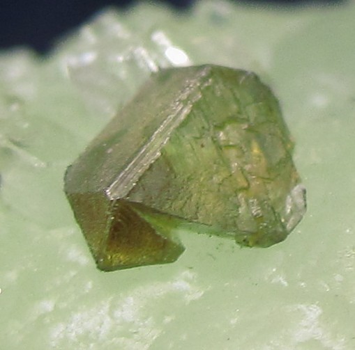
| Species: | Sphalerite |
| Formula: | ZnS |
| Comments: | Typically isolated micro-crystals to 6 mm perched on prehnite, complex forms, transparent and lustrous. |
| Habit: | complex tetrahedra |
| Colour: | pale brown to olive green |
| Quality for species: | Good crystals or rich for species - important (!) |
| Abundance at site: | Rare |
| Confirmation |
|---|
|
| Validity: | Confirmed |
| Confirmation Methods: | Visually Identified |
| Associated Minerals Based on Photo Data: |
|---|
|
| Prehnite | ⓘ17 photos of Sphalerite associated with Prehnite at this locality. |
| Pumpellyite Group | ⓘ3 photos of Sphalerite associated with Pumpellyite Group at this locality. |
| Calcite | ⓘ1 photo of Sphalerite associated with Calcite at this locality. |
| Anhydrite | ⓘ1 photo of Sphalerite associated with Anhydrite at this locality. |
| Datolite | ⓘ1 photo of Sphalerite associated with Datolite at this locality. |
| Data |
|---|
|
| Mineral Data: | Click here to view Sphalerite data |
| Locality Data: | Click here to view O & G Southbury Quarry (Silliman Quarry; O & G No. 2 Quarry), Orenaug Hills, Woodbury, Litchfield County, Connecticut, USA |
| Photo Gallery | View Gallery (17 photos) |
| Data Identifiers |
|---|
|
| Mindat Occurrence Record ID: | 350158 |
| Long-form Identifier: | 1:3:350158:0 |
| GUID (UUID V4): | 2821c4ea-a21e-4bde-b4c4-6de2debe97de |
| Nearest other occurrences of Sphalerite |
|---|
|
|
| 10.6km (6.6 miles) | ⓘSandy Hook gold mine (Blackwell's mine), Sandy Hook, Newtown, Fairfield County, Connecticut, USA |
| 11.9km (7.4 miles) | ⓘRockside Quarry (Mine Hill Quarry), Mine Hill (Ore Hill), Roxbury, Litchfield County, Connecticut, USA |
| 12.1km (7.5 miles) | ⓘRoxbury Iron Mine (Shepaug Iron Company Mine; Shepaug Spathic Iron and Steel Company Mine), Mine Hill (Ore Hill), Roxbury, Litchfield County, Connecticut, USA |
| 13.8km (8.6 miles) | ⓘStevenson Mine (Burke's Copper Mine), Oxford, New Haven County, Connecticut, USA |
| 15.8km (9.8 miles) | ⓘState Route 8 exit 37, Watertown, Litchfield County, Connecticut, USA |
| 16.5km (10.2 miles) | ⓘU. S. Route 7 Expressway (Danbury line to Iron Works District), Brookfield, Fairfield County, Connecticut, USA |
| 16.6km (10.3 miles) | ⓘOld lead mine, Brookfield, Fairfield County, Connecticut, USA |
| 19.1km (11.9 miles) | ⓘSilver mine, Seymour, New Haven County, Connecticut, USA |
| 19.3km (12.0 miles) | ⓘReynolds Bridge, Thomaston, Litchfield County, Connecticut, USA |
| 20.0km (12.4 miles) | ⓘBooth's Mine (Booth's Bismuth Mine; Booth-Hurd's Bismuth Mine), Monroe, Fairfield County, Connecticut, USA |
| References |
|---|
|
|


O & G Southbury Quarry, Orenaug Hills, Woodbury, Litchfield County, Connecticut, USA