| Locality type: | Prospect |
| Classification |
|---|
|
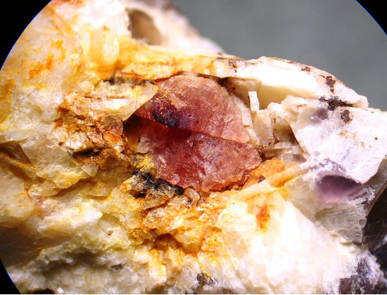
| Species: | Fluorite var: Chlorophane |
| Formula: | CaF2 |
| Comments: | Crystals or masses typically crumble so rarely intact or on matrix. |
| Habit: | massive to crudely octahedral |
| Colour: | pink to dark red |
| Luminescent properties: | blue-green |
| Quality for species: | Poor for species, only of interest for locality collectors. (#) |
| Abundance at site: | Rare |
| Confirmation |
|---|
|
| Validity: | Believed Valid |
| Data |
|---|
|
| Mineral Data: | Click here to view Chlorophane data |
| Locality Data: | Click here to view Hollister prospects, South Glastonbury, Glastonbury, Hartford County, Connecticut, USA |
| Photo Gallery | View Gallery (3 photos) |
| Data Identifiers |
|---|
|
| Mindat Occurrence Record ID: | 736245 |
| Long-form Identifier: | 1:3:736245:3 |
| GUID (UUID V4): | 71d05dde-5917-4ec9-8573-ee3c3d5d90e7 |
| Nearest other occurrences of Chlorophane |
|---|
|
|
| 9.6km (6.0 miles) | ⓘRiverside Quarry (Western Quarry), White Rock Mining District, Middletown, Middlesex County, Connecticut, USA |
| 11.7km (7.2 miles) | ⓘLinkpot cut, Airline Railroad, East Hampton (Chatham), Middlesex County, Connecticut, USA |
| 15.8km (9.8 miles) | ⓘSlocum prospect, East Hampton (Chatham), Middlesex County, Connecticut, USA |
| 18.0km (11.2 miles) | ⓘGillette Quarry (J-J Mine; Haddam Neck Quarry), Haddam Neck, Haddam, Middlesex County, Connecticut, USA |
| 22.2km (13.8 miles) | ⓘHewitt Gem Quarry (Herb's Gem Quarry; Sawmill Quarry), Haddam, Middlesex County, Connecticut, USA |
| 65.6km (40.8 miles) | ⓘCorporate Drive, Long Hill, Trumbull, Fairfield County, Connecticut, USA |
| 66.1km (41.1 miles) | ⓘOld Mine Park (Old Tungsten Mine), Long Hill, Trumbull, Fairfield County, Connecticut, USA |
| 66.2km (41.2 miles) | ⓘOld Mine Plaza construction site, Long Hill, Trumbull, Fairfield County, Connecticut, USA |
| 66.6km (41.4 miles) | ⓘState Route 111 construction site, Long Hill, Trumbull, Fairfield County, Connecticut, USA |
| 82.2km (51.1 miles) | ⓘFillow Quarry (Branchville Quarry; Branchville Mica Mine; Smith Mine), Branchville, Redding (Reading), Fairfield County, Connecticut, USA |
| References |
|---|
|
|


Hollister prospects, South Glastonbury, Glastonbury, Hartford County, Connecticut, USA