| Locality type: | Hill |
| Classification |
|---|
|
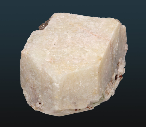
| Species: | Microcline |
| Formula: | K(AlSi3O8) |
| Comments: | Good subhedral crystals where formed against the quartz cores of the pegmatites. Stugard (1958) established that microcline is the K-feldspar of tbe pegmatite district. |
| Colour: | white to pale tan |
| Quality for species: | Good crystals or rich for species - important (!) |
| Abundance at site: | Extremely common |
| Confirmation |
|---|
|
| Validity: | Believed Valid |
| Associated Minerals Based on Photo Data: |
|---|
|
| Smoky Quartz | ⓘ10 photos of Microcline associated with Smoky Quartz at this locality. |
| Albite | ⓘ7 photos of Microcline associated with Albite at this locality. |
| Beryl | ⓘ4 photos of Microcline associated with Beryl at this locality. |
| Almandine | ⓘ3 photos of Microcline associated with Almandine at this locality. |
| Quartz | ⓘ2 photos of Microcline associated with Quartz at this locality. |
| Columbite-(Fe)-Columbite-(Mn) Series | ⓘ1 photo of Microcline associated with Columbite-(Fe)-Columbite-(Mn) Series at this locality. |
| Fluorapatite | ⓘ1 photo of Microcline associated with Fluorapatite at this locality. |
| Schorl | ⓘ1 photo of Microcline associated with Schorl at this locality. |
| Data |
|---|
|
| Mineral Data: | Click here to view Microcline data |
| Locality Data: | Click here to view Quarry Hill (Brainerd Quarries; Shailor Quarries), Haddam Neck, Haddam, Middlesex County, Connecticut, USA |
| Photo Gallery | View Gallery (9 photos) |
| Data Identifiers |
|---|
|
| Mindat Occurrence Record ID: | 665421 |
| Long-form Identifier: | 1:3:665421:4 |
| GUID (UUID V4): | 69cd100d-c496-429c-b9ec-1556c633c8a3 |
| Nearest other occurrences of Microcline |
|---|
|
|
| 0.6km (0.4 miles) | ⓘGillette Quarry (J-J Mine; Haddam Neck Quarry), Haddam Neck, Haddam, Middlesex County, Connecticut, USA |
| 1.0km (0.6 miles) | ⓘConnecticut Yankee atomic power plant, Haddam Neck, Haddam, Middlesex County, Connecticut, USA |
| 1.8km (1.1 miles) | ⓘHill above the parsonage (unnamed feldspar quarry), Haddam, Middlesex County, Connecticut, USA |
| 1.9km (1.2 miles) | ⓘTidewater feldspar quarry, Haddam Neck, Haddam, Middlesex County, Connecticut, USA |
| 1.9km (1.2 miles) | ⓘArnold Granite Quarry (General Brainerd Quarry; Great Hill Quarry; Hazelton Quarry; Haddam Quarry; Brookes Quarry), Haddam, Middlesex County, Connecticut, USA |
| 2.1km (1.3 miles) | ⓘKnudsen prospects, Haddam Neck, Haddam, Middlesex County, Connecticut, USA |
| 2.1km (1.3 miles) | ⓘJail Hill Road locality (Jail Hill Quarry), Haddam, Middlesex County, Connecticut, USA |
| 2.2km (1.4 miles) | ⓘLong-lot Quarry, Haddam, Middlesex County, Connecticut, USA |
| 2.2km (1.4 miles) | ⓘKelsey prospect (Parmalee farm), Haddam, Middlesex County, Connecticut, USA |
| 2.2km (1.4 miles) | ⓘTourmaline locality, Haddam, Middlesex County, Connecticut, USA |
| References |
|---|
|
|


Quarry Hill, Haddam Neck, Haddam, Middlesex County, Connecticut, USA