Posadów quarry, Złotoryja, Złotoryja County, Lower Silesian Voivodeship, Polandi
| Regional Level Types | |
|---|---|
| Posadów quarry | - not defined - |
| Złotoryja | Town |
| Złotoryja County | County |
| Lower Silesian Voivodeship | Voivodeship |
| Poland | Country |
This page is currently not sponsored. Click here to sponsor this page.


Latitude & Longitude (WGS84):
51° 8' 0'' North , 15° 53' 31'' East
Latitude & Longitude (decimal):
Age:
23.03 to 5.332 Ma
Geologic Time:
Reference for age:
A.Bolewski, W.Parachoniak (1988) - Petrografia. Wydawnictwa Geologiczne - Warszawa
Köppen climate type:
Nearest Settlements:
| Place | Population | Distance |
|---|---|---|
| Złotoryja | 16,612 (2010) | 2.1km |
| Wilków | 2,000 (2010) | 5.2km |
| Pielgrzymka | 910 (2015) | 5.8km |
| Zagrodno | 1,626 (2010) | 6.7km |
| Olszanica | 1,118 (2010) | 10.4km |
Mindat Locality ID:
300794
Long-form identifier:
1:2:300794:8
GUID (UUID V4):
cb621951-3c40-455e-8cc4-c918e88ea259
Other/historical names associated with this locality:
Goldberg
Other Languages:
Polish:
"Oczko", Złotoryja, Powiat złotoryjski, Województwo dolnośląskie, Polska
Cenozoic Central European Volcanic Province.
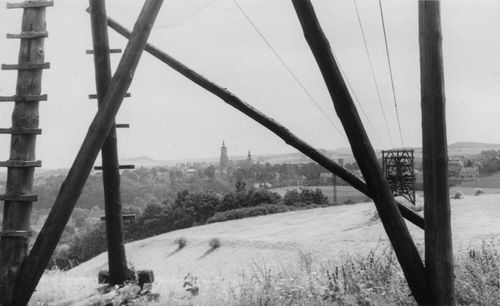
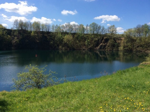
Closed basalt quarry, operating aprox.1926-1965, in the early 70's slowly flooded by water, today forming nearly perfect circle with a diameter of almost 150 m. In some pleaces still visible polygonal basalt pillars.The depth of the quarry during the operating period reached about 60 m. The cable railway system transported extracted basalt for the 800m distance to the railway ramp in Złotoryja (germ.Goldberg).
Select Mineral List Type
Standard Detailed Gallery Strunz Chemical ElementsMineral List
2 valid minerals.
Rock Types Recorded
Note: data is currently VERY limited. Please bear with us while we work towards adding this information!
Select Rock List Type
Alphabetical List Tree DiagramDetailed Mineral List:
| ⓘ Augite Formula: (CaxMgyFez)(Mgy1Fez1)Si2O6 Reference: K.Andrzejewski Collection; University of Silesia collection |
| ⓘ Calcite Formula: CaCO3 Reference: K.Andrzejewski Collection |

List of minerals arranged by Strunz 10th Edition classification
| Group 5 - Nitrates and Carbonates | |||
|---|---|---|---|
| ⓘ | Calcite | 5.AB.05 | CaCO3 |
| Group 9 - Silicates | |||
| ⓘ | Augite | 9.DA.15 | (CaxMgyFez)(Mgy1Fez1)Si2O6 |
List of minerals for each chemical element
| C | Carbon | |
|---|---|---|
| C | ⓘ Calcite | CaCO3 |
| O | Oxygen | |
| O | ⓘ Calcite | CaCO3 |
| O | ⓘ Augite | (CaxMgyFez)(Mgy1Fez1)Si2O6 |
| Mg | Magnesium | |
| Mg | ⓘ Augite | (CaxMgyFez)(Mgy1Fez1)Si2O6 |
| Si | Silicon | |
| Si | ⓘ Augite | (CaxMgyFez)(Mgy1Fez1)Si2O6 |
| Ca | Calcium | |
| Ca | ⓘ Calcite | CaCO3 |
| Ca | ⓘ Augite | (CaxMgyFez)(Mgy1Fez1)Si2O6 |
| Fe | Iron | |
| Fe | ⓘ Augite | (CaxMgyFez)(Mgy1Fez1)Si2O6 |
Other Regions, Features and Areas containing this locality
Czech Republic/Germany/Poland
- ⭔SilesiaRegion
Eurasian PlateTectonic Plate
EuropeContinent
- Bohemian MassifMassif
- SudetesMountain Range
- Western SudetesMountain Range
- SudetesMountain Range
This page contains all mineral locality references listed on mindat.org. This does not claim to be a complete list. If you know of more minerals from this site, please register so you can add to our database. This locality information is for reference purposes only. You should never attempt to
visit any sites listed in mindat.org without first ensuring that you have the permission of the land and/or mineral rights holders
for access and that you are aware of all safety precautions necessary.


Posadów quarry, Złotoryja, Złotoryja County, Lower Silesian Voivodeship, Poland