|
USA | |
|
| MRDS database Dep. ID file #10027942, MRDS ID #M004589. |
- Rawhide Mountains Wilderness Area
| Tosdal, B.B., et al (1990), USGS Bull. 1701-G: G6. |
|
| Tosdal, B.B., et al (1990), USGS Bull. 1701-G: G6. |
|
| Wilson, E.D., et al (1934)(revised 1967), Arizona Bureau of Mines Bull. 137: 126-127. |
|
| (n.d.) ADMMR Mines Database, Arizona Geological Survey.
Keith, Stanton B. (1978) State of Arizona Bureau of Geology and Mineral Technology, Geol. Sur. Br. Bull. 192, Index of Mining Properties in Yuma Co., Arizona: 122 (Table 4) |
|
| Keith, Stanton B. (1978) State of Arizona Bureau of Geology and Mineral Technology, Geol. Sur. Br. Bull. 192, Index of Mining Properties in Yuma Co., Arizona: 123 (Table 4). |
|
| MRDS database Dep. ID file #10027863, MRDS ID #M004242. |
|
| Keith, Stanton B. (1978) State of Arizona Bureau of Geology and Mineral Technology, Geol. Sur. Br. Bull. 192, Index of Mining Properties in Yuma Co., Arizona: 123 (Table 4). |
|
| MRDS database Dep. ID file #10027158, MRDS ID #M002308. |
|
| MRDS database Dep. ID file #10027704, MRDS ID #M003882. |
|
| MRDS database Dep. ID file #10027792, MRDS ID #M004122. |
|
| Keith, Stanton B. (1978) State of Arizona Bureau of Geology and Mineral Technology, Geol. Sur. Br. Bull. 192, Index of Mining Properties in Yuma Co., Arizona: 142 (Table 4). |
|
| MRDS database Dep. ID file #10027864, MRDS ID #M004243. |
|
| The-Vug.com Collecting Minerals of La Paz County DVD |
- Mammoth-Chicago-Copper Glance Mine group
| MRDS database Dep. ID file #10027051, MRDS ID #M001815. |
- Santa Maria Mining District (Planet Mining District; Swansea Mining District; Bill Williams Mining District)
| The-Vug.com Collecting Minerals of La Paz County DVD |
|
| Min. Record:20(5):387. |
|
| (n.d.) ADMMR Mines Database, Arizona Geological Survey.
Keith, Stanton B. (1978) State of Arizona Bureau of Geology and Mineral Technology, Geol. Sur. Br. Bull. 192, Index of Mining Properties in Yuma Co., Arizona: 173 (Table 4) |
|
| (n.d.) ADMMR Mines Database, Arizona Geological Survey.
Anthony, J.W., et al (1995), Mineralogy of Arizona, 3rd.ed.: 152
Keith, Stanton B. (1978) State of Arizona Bureau of Geology and Mineral Technology, Geol. Sur. Br. Bull. 192, Index of Mining Properties in Yuma Co., Arizona: 173 (Table 4)
Harrer (1964): 127-130
Bancroft (1911): 55-59 |
|
| Anthony, J.W., et al (1995), Mineralogy of Arizona, 3rd.ed.: 128, 173, 196, 286, 417
Galbraith, F.W. & D.J. Brennan (1959), Minerals of AZ: 110.
Cummings, J.B. (1946b), Exploration of New Planet iron deposit, Yuma Co., AZ, US Bur. Mines Rept. Inv. 3982
Bancroft, H. (1911), Reconnaissance of the ore deposits in northern Yuma Co., AZ, USGS Bull. 451
McCarn, H.L. (1904), The Planet copper mine, Engr. Mining Jour.: 78: 26 |
- Cunningham Pass Mining District
| Keith, Stanton B. (1978) State of Arizona Bureau of Geology and Mineral Technology, Geol. Sur. Br. Bull. 192, Index of Mining Properties in Yuma Co., Arizona: 143 (Table 4). |
|
| Keith, Stanton B. (1978) State of Arizona Bureau of Geology and Mineral Technology, Geol. Sur. Br. Bull. 192, Index of Mining Properties in Yuma Co., Arizona: 144 (Table 4). |
- La Cholla Mining District
| Keith, Stanton B. (1978) State of Arizona Bureau of Geology and Mineral Technology, Geol. Sur. Br. Bull. 192, Index of Mining Properties in Yuma Co., Arizona: 156 (Table 4) |
- La Paz Mining District (Weaver Mining District)
| MRDS database Dep. ID file #10056413, MRDS ID #TC00084. |
|
| Jerry A. Baird. |
- U.S. Army Yuma Proving Grounds
| (n.d.) ADMMR Mines Database, Arizona Geological Survey.
Keith, Stanton B. (1978) State of Arizona Bureau of Geology and Mineral Technology, Geol. Sur. Br. Bull. 192, Index of Mining Properties in Yuma Co., Arizona: 158 (Table 4) |
- Gila Bend Mountains Mining District
| AZ Bur. of Mines Bull. 134: 147. |
- Eagletail Mts (Cemetary Ridge)
- Eagle Tail Mining District
| Wilson, E.D. (1933), AZ Bur. of Mines Bull. 134: 142-143. |
- Ellsworth Mining District
| MRDS database Dep. ID file #10027677, MRDS ID #M003794. |
|
| Posted by Jerry A. Baird |
|
| MRDS database Dep. ID file #10027694, MRDS ID #M003845. |
- Harquahala Mining District
| Wilson, E.D., et al (1934), AZ Bur. of Mines Bull. 137: 133. |
|
| Keith, Stanton B. (1978) State of Arizona Bureau of Geology and Mineral Technology, Geol. Sur. Br. Bull. 192, Index of Mining Properties in Yuma Co., Arizona: 153 (Table 4) |
|
| (n.d.) ADMMR Mines Database, Arizona Geological Survey.
Hunt, William (1983) Calciovolborthite from the New Water Mountains, Yuma County, Arizona. The Mineralogical Record, 14 (2) 119
Ref.: Keith, Stanton B. (1978) State of Arizona Bureau of Geology and Mineral Technology, Geol. Sur. Br. Bull. 192, Index of Mining Properties in Yuma Co., Arizona: 164 (Table 4) |
|
| Anthony, J.W., et al (1995), Mineralogy of Arizona, 3rd.ed.: 173, 182
King, Vandall T., Robinson, George W. (1989) What's New in Minerals? - Sixteenth Annual Rochester Academy of Science Mineralogical Symposium. The Mineralogical Record, 20 (5) 387-399 |
|
| Hunt, William (1983) Calciovolborthite from the New Water Mountains, Yuma County, Arizona. The Mineralogical Record, 14 (2) 119 |
|
| (2005) Mineral Resources Data System (MRDS), US Geological Survey.
MRDS database Dep. ID file #10027702, MRDS ID #M003870. |
|
| (n.d.) ADMMR Mines Database, Arizona Geological Survey.
Keith, Stanton B. (1978) State of Arizona Bureau of Geology and Mineral Technology, Geol. Sur. Br. Bull. 192, Index of Mining Properties in Yuma Co., Arizona: 167 (Table 4) |
|
| Anthony, John W., Williams, Sidney A., Bideaux, Richard A., Grant, Raymond W. (1995) Mineralogy of Arizona (3rd ed.) University of Arizona Press, Tucson, AZ. |
|
| Anthony, J.W., et al (1995), Mineralogy of Arizona, 3rd.ed.: 130 |
|
| (n.d.) ADMMR Mines Database, Arizona Geological Survey.
Keith, Stanton B. (1978) State of Arizona Bureau of Geology and Mineral Technology, Geol. Sur. Br. Bull. 192, Index of Mining Properties in Yuma Co., Arizona: 170 (Table 4)
Bancroft (1911): 93-95 |
|
| Luetcke, Rolf (n.d.) Personal communication. |
|
| (n.d.) ADMMR Mines Database, Arizona Geological Survey.
Keith, Stanton B. (1978) State of Arizona Bureau of Geology and Mineral Technology, Geol. Sur. Br. Bull. 192, Index of Mining Properties in Yuma Co., Arizona: 171 (Table 4)
Bancroft (1911): 90-91 |
- Rawhide Mountains Wilderness Area
| Tosdal, B.B., et al (1990), USGS Bull. 1701-G: G7-G8, G12-G13. |
|
| Anthony, J.W., et al (1995), Mineralogy of Arizona, 3rd.ed.: 173. |
- Bonanza and Golden Eagle Mine group
| Luetcke, Rolf (n.d.) Personal communication. |
- U.S. Army Yuma Proving Grounds
| MRDS database Dep. ID file #10095031, MRDS ID #M002423. |
|
| Bancroft, Peter, Bricker, Garth (1990) Arizona's Silver Mining District. The Mineralogical Record, 21 (2) 151-168
Wilson, E.D. (1933), AZ Bur. of Mines Bull. 134: 60-62 |
|
| Anthony, J.W., et al (1995), Mineralogy of Arizona, 3rd.ed.: 330
Montoya, J. (1967), A new occurrence of planchéite in AZ, Rocks & Minerals: 277. |
|
| Mineral News (2002) 18-1 pp1,5-7 |
|
| Ron Layton |
|
| Dale Keiser Collection |
|
| Williams, S. A. (1982) Luddenite, a new copper-lead silicate from Arizona. Mineralogical Magazine, 46 (340) 363-364 doi:10.1180/minmag.1982.046.340.11 |
- Cleopatra Mining District
- Kimble Mining Sub-District
| Tosdal, B.B., et al (1990), USGS Bull. 1701-G: G-7. |
|
| MRDS file #10027683. |
|
| Personally collected by Jerry A. Baird in October 2011. PXRD identification on mimetite and creaseyite by Tony Kampf. Wet chemical and visual identification on other minerals. |
|
| Luetcke, Rolf (n.d.) Personal communication. |
|
| MRDS file #10037093. |
- Bullard Peak (Smith Peak)
| MRDS database Dep. ID #10048271, MRDS ID #M800394. |
- Castle Dome Mining District
| Luetcke, Rolf (n.d.) Personal communication. |
- Sheep Tanks Mining District
| Wilson, E.D., et al (1934)(revised 1967), AZ Bur. Mines Bull. 137: 144-145.
Wilson, E.D. (1933), AZ Bur. Mines Bull. 134: 132-140 |
|
| Luetcke, Rolf (n.d.) Personal communication. |
- Tank Mountains Mining District
| AZ Bur. of Mines Bull. 134: 125-126. |
- U.S. Army Yuma Proving Grounds
| Wilson, E.D., AZ Bur. Mines bull. 134: 126. |
|
| CDMG OFR 94-11 " Mineral Land Classification of the Eastern Half of Riverside Co. CA" |
|
| CDMG OFR 94-11 " Mineral Land Classification of the Eastern Half of Riverside Co. CA" |
|
| California Division of Mines and Geology Open-File Report 94-11 (1994): Mineral Land Classification of the Eastern Half of Riverside County, California. |
|
| CDMG OFR 94-11 " Mineral Land Classification of the Eastern Half of Riverside Co. CA" |
|
| CDMG OFR 94-11 " Mineral Land Classification of the Eastern Half of Riverside Co. CA" |
|
| CDMG OFR 94-11 " Mineral Land Classification of the Eastern Half of Riverside Co. CA" |
- Riverside Mts (Siakariri)
- Bendigo District (Riverside Mountain District)
| CDMG OFR 94-11 " Mineral Land Classification of the Eastern Half of Riverside Co. CA" |
|
| CDMG OFR 88-20 "Mineral Land Classification of the Whipple Mts & Riverside Mts Study Area, S. Bernardino & Riverside Co's CA" |
|
| CDMG OFR 88-20 "Mineral Land Classification of the Whipple Mts & Riverside Mts Study Area, S. Bernardino & Riverside Co's CA" |
|
| CDMG OFR 88-20 "Mineral Land Classification of the Whipple Mts & Riverside Mts Study Area, S. Bernardino & Riverside Co's CA" |
|
| CDMG OFR 88-20 "Mineral Land Classification of the Whipple Mts & Riverside Mts Study Area, S. Bernardino & Riverside Co's CA" |
|
| CDMG OFR 88-20 "Mineral Land Classification of the Whipple Mts & Riverside Mts Study Area, S. Bernardino & Riverside Co's CA" |
|
| CDMG OFR 94-11 " Mineral Land Classification of the Eastern Half of Riverside Co. CA" |
|
| CDMG OFR 88-20 "Mineral Land Classification of the Whipple Mts & Riverside Mts Study Area, S. Bernardino & Riverside Co's CA" |
|
| CDMG OFR 88-20 "Mineral Land Classification of the Whipple Mts & Riverside Mts Study Area, S. Bernardino & Riverside Co's CA" |
- Whipple District (Monumental District)
| (2005) Mineral Resources Data System (MRDS), US Geological Survey. |
|
| Pemberton, H. Earl (1983) Minerals of California. Van Nostrand Reinhold Company Inc.
Wright, L.A., et al (1953), Mines and mineral resources of San Bernardino County, California: California Journal of Mines and Geology: 49(1-2): tabulated list of mines: 13-15, 34
Van Nostrand Reinholt Press: 514. |
|
| (2005) Mineral Resources Data System (MRDS), US Geological Survey. |
|
| (2005) Mineral Resources Data System (MRDS), US Geological Survey. |
|
| (2005) Mineral Resources Data System (MRDS), US Geological Survey. |
- Havasu Palms (Roads End Camp)
| (2005) Mineral Resources Data System (MRDS), US Geological Survey. |
|
| (2005) Mineral Resources Data System (MRDS), US Geological Survey. |
|
| (2005) Mineral Resources Data System (MRDS), US Geological Survey. |
|
| (2005) Mineral Resources Data System (MRDS), US Geological Survey. |
|
| (2005) Mineral Resources Data System (MRDS), US Geological Survey. |
|
| (2005) Mineral Resources Data System (MRDS), US Geological Survey. |
|
| (2005) Mineral Resources Data System (MRDS), US Geological Survey. |
|
| (2005) Mineral Resources Data System (MRDS), US Geological Survey. |
|
| (2005) Mineral Resources Data System (MRDS), US Geological Survey. |
|
| (2005) Mineral Resources Data System (MRDS), US Geological Survey. |
|
| (2005) Mineral Resources Data System (MRDS), US Geological Survey. |
|
| (2005) Mineral Resources Data System (MRDS), US Geological Survey. |
|
| (2005) Mineral Resources Data System (MRDS), US Geological Survey. |
|
| (2005) Mineral Resources Data System (MRDS), US Geological Survey. |
|
| (2005) Mineral Resources Data System (MRDS), US Geological Survey. |
|
| (2005) Mineral Resources Data System (MRDS), US Geological Survey. |
|
| Pemberton, H. Earl (1983) Minerals of California. Van Nostrand Reinhold Company Inc.
Wright, L.A., et al (1953), Mines and mineral resources of San Bernardino County, California: California Journal of Mines and Geology: 49(1-2): 13-15, 34, tabulated list of mines
Van Nostrand Reinholt Press: 514. |
|
| (2005) Mineral Resources Data System (MRDS), US Geological Survey. |
|
| (2005) Mineral Resources Data System (MRDS), US Geological Survey. |
|
| (2005) Mineral Resources Data System (MRDS), US Geological Survey. |
|
| (2005) Mineral Resources Data System (MRDS), US Geological Survey. |
|
| (2005) Mineral Resources Data System (MRDS), US Geological Survey. |
|
| (2005) Mineral Resources Data System (MRDS), US Geological Survey. |
|
| (2005) Mineral Resources Data System (MRDS), US Geological Survey. |
|
| (2005) Mineral Resources Data System (MRDS), US Geological Survey. |
|
| (2005) Mineral Resources Data System (MRDS), US Geological Survey. |
|
| (2005) Mineral Resources Data System (MRDS), US Geological Survey. |
|
| (2005) Mineral Resources Data System (MRDS), US Geological Survey. |

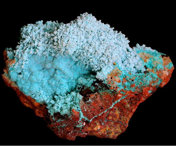


Eagle Tail group, Eagle Tail Mining District, Eagletail Mts, La Paz County, Arizona, USA