| Locality | Latitude | Longitude | Distance | Bearing |
|---|
| Hjarðardalur, Hellurnar, Eysturoy, Eysturoy Region, Faroe Islands | 62° 15' 9" N | 6° 51' 46" W | 1.4km (0.9 miles) | |
| Heltnará, Millum Fjarða, Funningsfjørđur, Eysturoy, Eysturoy Region, Faroe Islands | 62° 13' 16" N | 6° 52' 53" W | 3.8km (2.4 miles) | |
| Millum Fjarða, Funningsfjørđur, Eysturoy, Eysturoy Region, Faroe Islands | 62° 13' 7" N | 6° 54' 22" W | 4.9km (3.0 miles) | |
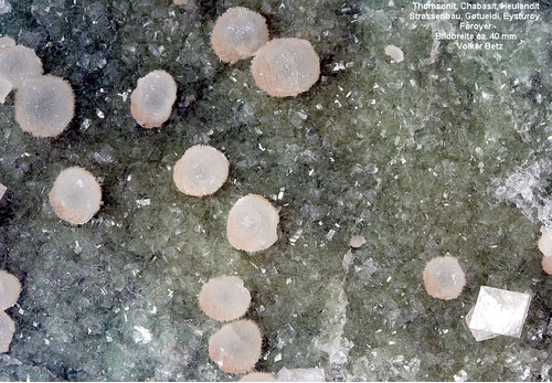
| Skipagjogv Quarry, Funningsfjørđur, Eysturoy, Eysturoy Region, Faroe Islands | 62° 14' 8" N | 6° 56' 8" W | 5.3km (3.3 miles) | |
| Funningur Roadcut, Funningsfjørđur, Eysturoy, Eysturoy Region, Faroe Islands | 62° 14' 24" N | 6° 56' 39" W | 5.6km (3.5 miles) | |
| Húsafjall, Funningur, Eysturoy, Eysturoy Region, Faroe Islands | 62° 16' 25" N | 6° 57' 35" W | 6.9km (4.3 miles) | |
| Hvítusteinar Quarry, Skálabotnur, Eysturoy, Eysturoy Region, Faroe Islands | 62° 11' 8" N | 6° 50' 21" W | 7.0km (4.3 miles) | |
| Nordskáli Tunnel, Norðskáli, Eysturoy, Eysturoy Region, Faroe Islands | 62° 13' 12" N | 6° 57' 48" W | 7.2km (4.5 miles) | |
| Norđragøta, Eysturoy, Eysturoy Region, Faroe Islands | 62° 11' 58" N | 6° 44' 35" W | 7.3km (4.5 miles) | |
| Eidi II Hydropower Tunnel, Selatrað, Eysturoy, Eysturoy Region, Faroe Islands | 62° 11' 25" N | 6° 55' 31" W | 7.9km (4.9 miles) | |
| Funningur, Eysturoy, Eysturoy Region, Faroe Islands | 62° 17' 16" N | 6° 58' 0" W | 8.0km (5.0 miles) | |
| Leirvik, Eysturoy, Eysturoy Region, Faroe Islands | 62° 12' 39" N | 6° 42' 21" W | 8.0km (5.0 miles) | |
| Syðrugøta, Eysturoy, Eysturoy Region, Faroe Islands | 62° 11' 9" N | 6° 45' 20" W | 8.2km (5.1 miles) | |
| Gøtueið, Syðrugøta, Eysturoy, Eysturoy Region, Faroe Islands | 62° 10' 40" N | 6° 45' 53" W | 8.7km (5.4 miles) | |
| Gøtueiđi, Eysturoy, Eysturoy Region, Faroe Islands | 62° 10' 29" N | 6° 46' 18" W | 8.9km (5.5 miles) | |
| Gøtuvegur Roadcut, Skipanes, Eysturoy, Eysturoy Region, Faroe Islands | 62° 10' 29" N | 6° 46' 2" W | 9.0km (5.6 miles) | |
| Skipanes, Eysturoy, Eysturoy Region, Faroe Islands | 62° 10' 24" N | 6° 46' 20" W | 9.0km (5.6 miles) | |
| The Northern Isles Tunnel, Leirvik, Eysturoy, Eysturoy Region, Faroe Islands | 62° 12' 24" N | 6° 40' 47" W | 9.4km (5.8 miles) | |
| Svínáir, Eysturoy, Eysturoy Region, Faroe Islands | 62° 13' 44" N | 7° 1' 30" W | 10.0km (6.2 miles) | |
| Sundalagið, Streymoy, Streymoy Region, Faroe Islands | 62° 13' 32" N | 7° 2' 16" W | 10.7km (6.6 miles) | |
| Uppi á Dal, Kunoy, Kunoy, Norðoyar Region, Faroe Islands | 62° 17' 33" N | 6° 39' 8" W | 10.8km (6.7 miles) | |
| Skáli Roadcuts, Skála, Eysturoy, Eysturoy Region, Faroe Islands | 62° 9' 17" N | 6° 47' 0" W | 10.8km (6.7 miles) | |
| Nesvik Quarry, Nesvik, Streymoy, Streymoy Region, Faroe Islands | 62° 13' 20" N | 7° 2' 26" W | 10.9km (6.8 miles) | |
| Ljósá, Eysturoy, Eysturoy Region, Faroe Islands | 62° 16' 1" N | 7° 3' 45" W | 11.8km (7.3 miles) | |
| Rossafelli, Nesvik, Streymoy, Streymoy Region, Faroe Islands | 62° 12' 33" N | 7° 3' 1" W | 11.9km (7.4 miles) | |
| Við Áir, Streymnes, Streymoy, Streymoy Region, Faroe Islands | 62° 11' 22" N | 7° 1' 50" W | 12.0km (7.4 miles) | |
| Ljósá Quarry, Eiði, Eysturoy, Eysturoy Region, Faroe Islands | 62° 16' 27" N | 7° 3' 51" W | 12.1km (7.5 miles) | |
| Hósvik, Streymoy, Streymoy Region, Faroe Islands | 62° 9' 4" N | 6° 56' 26" W | 12.1km (7.5 miles) | |
| Selatrađ Quarry, Morskranes, Eysturoy, Eysturoy Region, Faroe Islands | 62° 8' 16" N | 6° 50' 53" W | 12.3km (7.7 miles) | |
| Unnamed Quarry, Haraldssund, Kunoy, Norðoyar Region, Faroe Islands | 62° 16' 28" N | 6° 36' 20" W | 12.4km (7.7 miles) | |


Eidi II Hydropower Tunnel, Selatrað, Eysturoy, Eysturoy Region, Faroe Islands