| Locality | Latitude | Longitude | Distance | Bearing |
|---|
| Coker No. 2 Mine, Livingston, Upper Mississippi Valley Mining District, Iowa County, Wisconsin, USA | 42° 52' 35" N | 90° 23' 46" W | 0.0km (0.0 miles) | |
| Sunset Mine, Livingston, Upper Mississippi Valley Mining District, Iowa County, Wisconsin, USA | 42° 52' 37" N | 90° 23' 44" W | 0.1km (0.0 miles) | |
| Sunrise Mine, Livingston, Upper Mississippi Valley Mining District, Iowa County, Wisconsin, USA | 42° 52' 36" N | 90° 23' 53" W | 0.2km (0.1 miles) | |
| Senator Mine, Livingston, Upper Mississippi Valley Mining District, Iowa County, Wisconsin, USA | 42° 52' 23" N | 90° 23' 17" W | 0.8km (0.5 miles) | |
| Rundell Mine, Livingston, Upper Mississippi Valley Mining District, Iowa County, Wisconsin, USA | 42° 52' 36" N | 90° 24' 24" W | 0.9km (0.5 miles) | |
| Coker No. 3 Mine (M and A Mine; Big Tom Mine), Livingston, Upper Mississippi Valley Mining District, Iowa County, Wisconsin, USA | 42° 52' 8" N | 90° 23' 48" W | 0.9km (0.5 miles) | |
| Mifflin Mine, Mifflin area mines, Upper Mississippi Valley Mining District, Iowa County, Wisconsin, USA | 42° 53' 2" N | 90° 23' 15" W | 1.1km (0.7 miles) | |
| Bickford Mine, Livingston, Upper Mississippi Valley Mining District, Iowa County, Wisconsin, USA | 42° 53' 11" N | 90° 23' 27" W | 1.2km (0.7 miles) | |
| Dale Rundell Mine, Livingston, Upper Mississippi Valley Mining District, Iowa County, Wisconsin, USA | 42° 52' 26" N | 90° 24' 35" W | 1.2km (0.7 miles) | |
| Coker No. 1 Mine, Livingston, Upper Mississippi Valley Mining District, Iowa County, Wisconsin, USA | 42° 53' 11" N | 90° 23' 21" W | 1.2km (0.8 miles) | |
| North Coker Mine, Livingston, Upper Mississippi Valley Mining District, Iowa County, Wisconsin, USA | 42° 53' 11" N | 90° 23' 21" W | 1.2km (0.8 miles) | |
| Yewdall Mine, Livingston, Upper Mississippi Valley Mining District, Iowa County, Wisconsin, USA | 42° 52' 32" N | 90° 24' 56" W | 1.6km (1.0 miles) | |
| New Dale Rundell Mine, Livingston, Upper Mississippi Valley Mining District, Iowa County, Wisconsin, USA | 42° 51' 56" N | 90° 24' 41" W | 1.7km (1.1 miles) | |
| Defense Mine, Mifflin area mines, Upper Mississippi Valley Mining District, Iowa County, Wisconsin, USA | 42° 52' 28" N | 90° 22' 21" W | 1.9km (1.2 miles) | |
| Clayton Mine, Mifflin area mines, Upper Mississippi Valley Mining District, Iowa County, Wisconsin, USA | 42° 52' 17" N | 90° 22' 4" W | 2.4km (1.5 miles) | |
| Unnamed Pb mine [01], Mifflin area mines, Upper Mississippi Valley Mining District, Iowa County, Wisconsin, USA | 42° 51' 55" N | 90° 22' 14" W | 2.4km (1.5 miles) | |
| Unnamed Pb pits [01], Livingston, Upper Mississippi Valley Mining District, Iowa County, Wisconsin, USA | 42° 52' 6" N | 90° 25' 27" W | 2.4km (1.5 miles) | |
| Ebenezer Mine, Livingston, Upper Mississippi Valley Mining District, Iowa County, Wisconsin, USA | 42° 52' 15" N | 90° 25' 35" W | 2.5km (1.6 miles) | |
| Dolphin Mine, Livingston, Upper Mississippi Valley Mining District, Iowa County, Wisconsin, USA | 42° 53' 54" N | 90° 23' 12" W | 2.6km (1.6 miles) | |
| Ludd Mine, Livingston, Upper Mississippi Valley Mining District, Iowa County, Wisconsin, USA | 42° 53' 57" N | 90° 24' 28" W | 2.7km (1.7 miles) | |
| Old Gruno Mine (Miller Mine), Mifflin area mines, Upper Mississippi Valley Mining District, Iowa County, Wisconsin, USA | 42° 52' 9" N | 90° 21' 47" W | 2.8km (1.8 miles) | |
| New Gruno Mine, Mifflin area mines, Upper Mississippi Valley Mining District, Iowa County, Wisconsin, USA | 42° 52' 14" N | 90° 21' 38" W | 3.0km (1.8 miles) | |
| Okay Mine, Mifflin area mines, Upper Mississippi Valley Mining District, Iowa County, Wisconsin, USA | 42° 52' 37" N | 90° 20' 57" W | 3.8km (2.4 miles) | |
| Knight Quarry (George Wendland; Inc.), Iowa County, Wisconsin, USA | 42° 54' 32" N | 90° 22' 44" W | 3.9km (2.4 miles) | |
| Johnston Quarry, Iowa County, Wisconsin, USA | 42° 53' 39" N | 90° 20' 59" W | 4.3km (2.6 miles) | |
| Slack Mine, Mifflin area mines, Upper Mississippi Valley Mining District, Iowa County, Wisconsin, USA | 42° 52' 38" N | 90° 20' 24" W | 4.6km (2.8 miles) | |
| Old Slack Mine, Mifflin area mines, Upper Mississippi Valley Mining District, Iowa County, Wisconsin, USA | 42° 52' 19" N | 90° 20' 21" W | 4.7km (2.9 miles) | |
| Unnamed Zn mines [01], Mifflin area mines, Upper Mississippi Valley Mining District, Iowa County, Wisconsin, USA | 42° 52' 0" N | 90° 20' 21" W | 4.8km (3.0 miles) | |
| Ivey Construction Company Quarry, Iowa County, Wisconsin, USA | 42° 54' 48" N | 90° 21' 47" W | 4.9km (3.0 miles) | |
| Arthur area, Upper Mississippi Valley Mining District, Grant County, Wisconsin, USA | 42° 50' 47" N | 90° 26' 47" W | 5.3km (3.3 miles) | |
Minerals recorded nearby (within 5.3 km)
Rock types recorded nearby (within 5.3 km)
Entries shown in red are rocks recorded for this region.

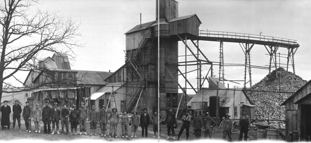


Coker No. 1 Mine, Livingston, Upper Mississippi Valley Mining District, Iowa County, Wisconsin, USA