| Locality | Latitude | Longitude | Distance | Bearing |
|---|
| Federal Reserve X-37 Prospect (Federal Mining Company), Cuyuna North Range, Crow Wing County, Minnesota, USA | 46° 30' 55" N | 93° 55' 6" W | 0.4km (0.2 miles) | |
| Kona Reserve X-21 Prospect (Cuyuna Village), Cuyuna North Range, Crow Wing County, Minnesota, USA | 46° 30' 47" N | 93° 55' 26" W | 0.4km (0.3 miles) | |
| Robert Mine (Roberts Mine; Kennedy Mine), Cuyuna North Range, Crow Wing County, Minnesota, USA | 46° 31' 40" N | 93° 55' 12" W | 1.2km (0.8 miles) | |
| Erich Reserve X-60 Prospect (Northern City Nat Bk Trustee et al), Cuyuna North Range, Crow Wing County, Minnesota, USA | 46° 31' 21" N | 93° 54' 29" W | 1.3km (0.8 miles) | |
| Kennedy mine, Cuyuna North Range, Crow Wing County, Minnesota, USA | 46° 31' 28" N | 93° 54' 29" W | 1.4km (0.9 miles) | |
| Rabbit Lake mine, Cuyuna North Range, Crow Wing County, Minnesota, USA | 46° 31' 55" N | 93° 54' 43" W | 1.9km (1.2 miles) | |
| South Yawkey Mine, Cuyuna North Range, Crow Wing County, Minnesota, USA | 46° 29' 54" N | 93° 56' 18" W | 2.4km (1.5 miles) | |
| North Yawkey mine, Cuyuna North Range, Crow Wing County, Minnesota, USA | 46° 29' 54" N | 93° 56' 38" W | 2.6km (1.6 miles) | |
| West Airport Mine (State of Minnesota et al), Cuyuna North Range, Crow Wing County, Minnesota, USA | 46° 29' 41" N | 93° 56' 38" W | 2.9km (1.8 miles) | |
| Manuel mine, Cuyuna North Range, Crow Wing County, Minnesota, USA | 46° 29' 34" N | 93° 56' 19" W | 2.9km (1.8 miles) | |
| Northland mine, Cuyuna North Range, Crow Wing County, Minnesota, USA | 46° 32' 48" N | 93° 54' 39" W | 3.4km (2.1 miles) | |
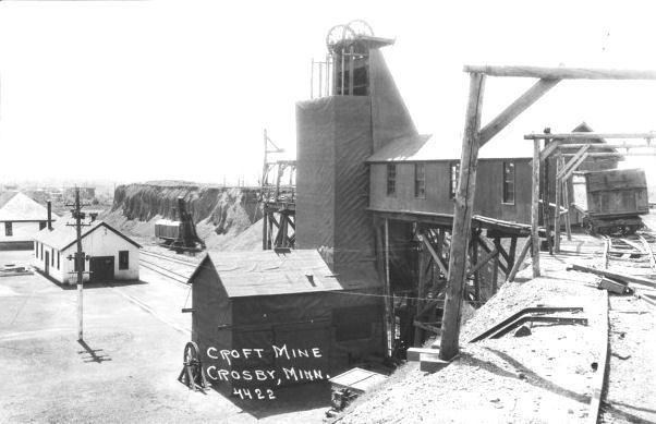
| Croft mine, Cuyuna North Range, Crow Wing County, Minnesota, USA | 46° 29' 30" N | 93° 57' 6" W | 3.6km (2.2 miles) | |
| Colonization Reserve H-41 (Hanna Mining Company), Cuyuna North Range, Crow Wing County, Minnesota, USA | 46° 32' 22" N | 93° 57' 39" W | 3.9km (2.4 miles) | |
| Meacham mine, Cuyuna North Range, Crow Wing County, Minnesota, USA | 46° 29' 14" N | 93° 57' 16" W | 4.1km (2.5 miles) | |
| Wearne mine, Portsmouth Mine, Cuyuna North Range, Crow Wing County, Minnesota, USA | 46° 29' 24" N | 93° 57' 50" W | 4.3km (2.7 miles) | |
| Meacham mine, Portsmouth Mine, Cuyuna North Range, Crow Wing County, Minnesota, USA | 46° 29' 13" N | 93° 57' 37" W | 4.4km (2.7 miles) | |
| Portsmouth Mine, Cuyuna North Range, Crow Wing County, Minnesota, USA | 46° 29' 22" N | 93° 57' 59" W | 4.5km (2.8 miles) | |
| Milford Mine, Cuyuna North Range, Crow Wing County, Minnesota, USA | 46° 32' 14" N | 93° 58' 28" W | 4.6km (2.8 miles) | |
| Healy mine, Portsmouth Mine, Cuyuna North Range, Crow Wing County, Minnesota, USA | 46° 29' 15" N | 93° 57' 52" W | 4.6km (2.8 miles) | |
| Osberg mine, Portsmouth Mine, Cuyuna North Range, Crow Wing County, Minnesota, USA | 46° 29' 26" N | 93° 58' 8" W | 4.6km (2.8 miles) | |
| Thompson mine, Portsmouth Mine, Cuyuna North Range, Crow Wing County, Minnesota, USA | 46° 29' 10" N | 93° 57' 46" W | 4.6km (2.9 miles) | |
| Pontiac Mine (Clark Mine; Joan No. 3 Reserve; Hanna Mining Company Agt; Lauretta Manganiferous Mines), Cuyuna North Range, Crow Wing County, Minnesota, USA | 46° 30' 46" N | 93° 59' 11" W | 4.9km (3.0 miles) | |
| Evergreen mine, Portsmouth Mine, Cuyuna North Range, Crow Wing County, Minnesota, USA | 46° 29' 13" N | 93° 58' 15" W | 4.9km (3.1 miles) | |
| Whitmarsh Reserve H-66 Prospect (Hanna Mining Company Agt), Cuyuna North Range, Crow Wing County, Minnesota, USA | 46° 31' 50" N | 93° 59' 13" W | 5.1km (3.2 miles) | |
| Armour No. 1 and No. 2 mines, Cuyuna North Range, Crow Wing County, Minnesota, USA | 46° 29' 1" N | 93° 58' 12" W | 5.2km (3.2 miles) | |
| Chisolm-Williams mine, Portsmouth Mine, Cuyuna North Range, Crow Wing County, Minnesota, USA | 46° 29' 17" N | 93° 58' 33" W | 5.2km (3.2 miles) | |
| Snyder Mine (Snyder Mining Company; Trespass Ore From Musser Mine), Roseau County, Minnesota, USA | 46° 30' 33" N | 93° 59' 29" W | 5.3km (3.3 miles) | |
| Snyder Mine (Snyder Mining Company; Trespass ore from Musser Mine), Cuyuna North Range, Crow Wing County, Minnesota, USA | 46° 30' 33" N | 93° 59' 29" W | 5.3km (3.3 miles) | |
| Sultana Mine (Pitt-Pac Company et al), Cuyuna North Range, Crow Wing County, Minnesota, USA | 46° 29' 34" N | 93° 58' 59" W | 5.3km (3.3 miles) | |
| Hopkins Mine (Hopkins-Sultana Mine; Pitt Pac Company et al), Cuyuna North Range, Crow Wing County, Minnesota, USA | 46° 29' 35" N | 93° 58' 59" W | 5.3km (3.3 miles) | |
Minerals recorded nearby (within 5.3 km)
Rock types recorded nearby (within 5.3 km)
Entries shown in red are rocks recorded for this region.


Armour No. 1 and No. 2 mines, Cuyuna North Range, Crow Wing County, Minnesota, USA