| Locality type: | Mine |
| Classification |
|---|
|
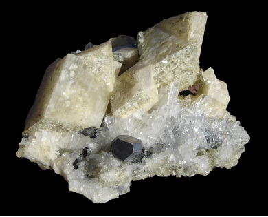
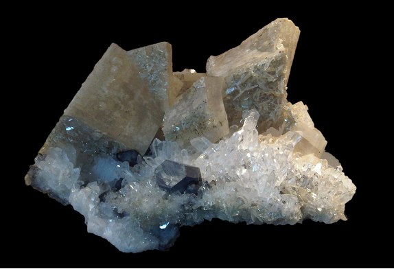
| Species: | Dolomite |
| Formula: | CaMg(CO3)2 |
| Comments: | Common gangue mineral often found lining cavities and vugs in the dolomite host rock. Occasionally found as floater material covered in brilliant crystallized sulfides. |
| Habit: | Cubic |
| Colour: | White, iron stained or ferroan |
| Quality for species: | Poor for species, only of interest for locality collectors. (#) |
| Abundance at site: | Common |
| Confirmation |
|---|
|
| Validity: | Confirmed |
| Confirmation Methods: | Visually Identified |
| Associated Minerals Based on Photo Data: |
|---|
|
| Sphalerite | ⓘ31 photos of Dolomite associated with Sphalerite at this locality. |
| Galena | ⓘ31 photos of Dolomite associated with Galena at this locality. |
| Quartz | ⓘ17 photos of Dolomite associated with Quartz at this locality. |
| Pyrite | ⓘ13 photos of Dolomite associated with Pyrite at this locality. |
| Tetrahedrite Subgroup | ⓘ9 photos of Dolomite associated with Tetrahedrite Subgroup at this locality. |
| Baryte | ⓘ5 photos of Dolomite associated with Baryte at this locality. |
| Chalcopyrite | ⓘ3 photos of Dolomite associated with Chalcopyrite at this locality. |
| Calcite | ⓘ2 photos of Dolomite associated with Calcite at this locality. |
| Chlorite Group | 1 photo of Dolomite associated with Chlorite Group at this locality. |
| Data |
|---|
|
| Mineral Data: | Click here to view Dolomite data |
| Locality Data: | Click here to view Mogul Mine (Garryard Mine; International Mogul Mines), Silvermines District, Tipperary County, Munster, Ireland |
| Photo Gallery | View Gallery (2 photos) |
| Data Identifiers |
|---|
|
| Mindat Occurrence Record ID: | 4628 |
| Long-form Identifier: | 1:3:4628:2 |
| GUID (UUID V4): | 359d40f6-6e14-4521-a0dc-329a26332c92 |
| Nearest other occurrences of Dolomite |
|---|
|
|
| 1.0km (0.6 miles) | ⓘBallynoe mine (Magcobar mine), Silvermines District, Tipperary County, Munster, Ireland |
| 1.9km (1.2 miles) | ⓘKnockanroe mine, Silvermines District, Tipperary County, Munster, Ireland |
| 2.3km (1.5 miles) | ⓘBallygown South Mine, Silvermines District, Tipperary County, Munster, Ireland |
| 30.8km (19.1 miles) | ⓘGortdrum Mine, Monard, Tipperary County, Munster, Ireland |
| 40.4km (25.1 miles) | ⓘLisheen mine, Moyne, Tipperary County, Munster, Ireland |
| 42.0km (26.1 miles) | ⓘTynagh Mine, Killimor, Galway County, Connacht, Ireland |
| 45.1km (28.0 miles) | ⓘGalmoy Mine, Johnstown, Kilkenny County, Leinster, Ireland |
| 51.9km (32.3 miles) | ⓘCourtbrown Zn-Pb deposit, Askeaton, Limerick County, Munster, Ireland |
| 69.8km (43.4 miles) | ⓘRenville (Rinville) Mine, Renville, Galway County, Connacht, Ireland |
| 73.7km (45.8 miles) | ⓘTullacondra Cu-Ag Deposit, Mallow, Cork County, Munster, Ireland |
| References |
|---|
|
|


Mogul Mine, Silvermines District, Tipperary County, Munster, Ireland