| Locality | Latitude | Longitude | Distance | Bearing |
|---|
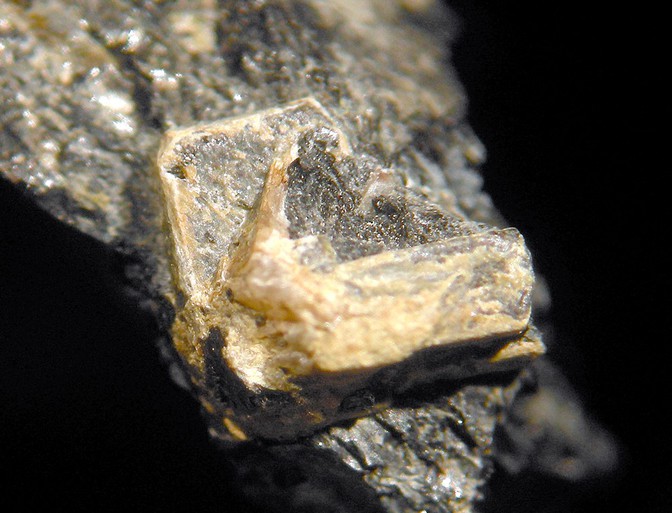
| Overlook Quarry (Atlas Feldspar Company Quarry; Atlas Quarry; Day Quarry), Overlook, Saratoga County, New York, USA | 43° 17' 30" N | 73° 56' 44" W | 0.0km (0.0 miles) | |
| Sacandaga Graphite Company Mine (Glen Falls Graphite Company Mine), Conklingville, Sacandaga Valley, Day Township, Saratoga County, New York, USA | 43° 18' 59" N | 73° 56' 59" W | 2.8km (1.7 miles) | |
| Garnet Pit, Batchellerville, Edinburg Township, Saratoga County, New York, USA | 43° 14' 21" N | 74° 3' 33" W | 10.9km (6.8 miles) | |
| Batchellerville, Saratoga County, New York, USA | 43° 14' 20" N | 74° 3' 36" W | 10.9km (6.8 miles) | |
| Corinth pegmatite outcrop, Corinth, Saratoga County, New York, USA | 43° 12' 0" N | 73° 52' 59" W | 11.4km (7.1 miles) | |
| Claspka Mining Company Quarry, Batchellerville, Edinburg Township, Saratoga County, New York, USA | 43° 15' 0" N | 74° 5' 0" W | 12.1km (7.5 miles) | |
| Mohawk Quarry, Batchellerville, Saratoga County, New York, USA | 43° 13' 0" N | 74° 5' 0" W | 13.9km (8.6 miles) | |
| Gordon Creek locality, Batchellerville, Edinburg Township, Saratoga County, New York, USA | 43° 12' 29" N | 74° 5' 0" W | 14.5km (9.0 miles) | |
| Graphite Products Corp. Mine (Saratoga Graphite Company Mine), Wilton Township, Saratoga County, New York, USA | 43° 15' 0" N | 73° 45' 0" W | 16.5km (10.3 miles) | |
| Flake Graphite Company Mine (Empire Graphite Company Mine), Greenfield Township, Saratoga County, New York, USA | 43° 5' 59" N | 73° 54' 0" W | 21.6km (13.4 miles) | |
| Greenfield, Greenfield Township, Saratoga County, New York, USA | 43° 6' 12" N | 73° 51' 51" W | 21.9km (13.6 miles) | |
| Lester Park, Greenfield Township, Saratoga County, New York, USA | 43° 5' 32" N | 73° 50' 53" W | 23.5km (14.6 miles) | |
| Greenfield pegmatite, Greenfield Township, Saratoga County, New York, USA | 43° 6' 29" N | 73° 46' 53" W | 24.4km (15.1 miles) | |
| Saratoga Springs, Saratoga County, New York, USA | 43° 4' 59" N | 73° 46' 59" W | 26.6km (16.6 miles) | |
| Belgian Block Quarry, Granite Mountain, Saratoga Springs, Saratoga County, New York, USA | 43° 4' 59" N | 73° 46' 59" W | 26.6km (16.6 miles) | |
| Gailor Quarry, Saratoga Springs, Saratoga County, New York, USA | 43° 4' 59" N | 73° 46' 59" W | 26.6km (16.6 miles) | |
| Mammoth Cave prospect, Warrensburg, Warrensburg Township, Warren County, New York, USA | 43° 30' 0" N | 73° 46' 30" W | 27.0km (16.8 miles) | |
| Werner Prospect 1, Mayfield, Fulton County, New York, USA | 43° 10' 20" N | 74° 15' 10" W | 28.2km (17.5 miles) | |
| Unnamed garnet deposit, Oven Mountain, North Creek, Warren County, New York, USA | 43° 34' 59" N | 73° 58' 59" W | 32.6km (20.2 miles) | |
| Richard Tyrell Farm Pegmatite Quarry, Richard Tyrell farm, Cranberry Creek, Mayfield, Fulton County, New York, USA | 43° 5' 59" N | 74° 16' 0" W | 33.6km (20.9 miles) | |
| Rowland Graphite Company Mine, Johnsburg Village (Johnsburgh), Johnsburg Township, Warren County, New York, USA | 43° 35' 59" N | 73° 56' 59" W | 34.3km (21.3 miles) | |
| Armstrong farm (Johnsburg Village), Johnsburg Township, Warren County, New York, USA | 43° 37' 0" N | 73° 58' 0" W | 36.2km (22.5 miles) | |
| Unnamed mica mine, Chestertown, Chester Township, Warren County, New York, USA | 43° 35' 59" N | 73° 48' 0" W | 36.2km (22.5 miles) | |
| Johnsburg Village (Johnsburgh), Johnsburg Township, Warren County, New York, USA | 43° 37' 6" N | 73° 57' 40" W | 36.4km (22.6 miles) | |
| Warren County Garnet Mills Mine, Wevertown, Warren County, New York, USA | 43° 38' 0" N | 73° 56' 29" W | 38.0km (23.6 miles) | |
| Fort Ann, Washington County, New York, USA | 43° 24' 51" N | 73° 29' 14" W | 39.5km (24.5 miles) | |
| Dominick Ashley Quarry, Putnam Mountain, Fort Ann, Washington County, New York, USA | 43° 29' 29" N | 73° 31' 50" W | 40.3km (25.0 miles) | |
| Chestertown pegmatite, Chestertown, Chester Township, Warren County, New York, USA | 43° 38' 59" N | 73° 47' 59" W | 41.5km (25.8 miles) | |
| C.A. Williams Mine, Chestertown, Chester Township, Warren County, New York, USA | 43° 39' 0" N | 73° 48' 0" W | 41.5km (25.8 miles) | |
| Unnamed pits, Horicon township, Warren County, New York, USA | 43° 38' 59" N | 73° 46' 0" W | 42.4km (26.3 miles) | |


Overlook Quarry, Overlook, Saratoga County, New York, USA