| Locality | Latitude | Longitude | Distance | Bearing |
|---|
| Bismuth northeast, Emmaville, Gough Co., New South Wales, Australia | 29° 15' 43" S | 151° 38' 13" E | 0.0km (0.0 miles) | |
| Bismuth Mine north, Clive Co., New South Wales, Australia | 29° 15' 54" S | 151° 38' 3" E | 0.4km (0.3 miles) | |
| Well Hidden deposit, Clive Co., New South Wales, Australia | 29° 15' 46" S | 151° 38' 30" E | 0.4km (0.3 miles) | |
| Bismuth Mine, Emmaville, Gough Co., New South Wales, Australia | 29° 16' 0" S | 151° 38' 5" E | 0.5km (0.3 miles) | |
| Fielders Hill south (East Block 14 Torrington), Clive Co., New South Wales, Australia | 29° 15' 29" S | 151° 37' 58" E | 0.6km (0.4 miles) | |
| High deposit 1, Gough Co., New South Wales, Australia | 29° 15' 30" S | 151° 37' 54" E | 0.7km (0.4 miles) | |
| Bismuth southeast, Emmaville, Gough Co., New South Wales, Australia | 29° 16' 5" S | 151° 38' 16" E | 0.7km (0.4 miles) | |
| Bismuth southwest, Emmaville, Gough Co., New South Wales, Australia | 29° 16' 2" S | 151° 38' 0" E | 0.7km (0.4 miles) | |
| Little Flaggy east, Clive Co., New South Wales, Australia | 29° 16' 0" S | 151° 37' 56" E | 0.7km (0.4 miles) | |
| Fielders deposit, Gough Co., New South Wales, Australia | 29° 15' 23" S | 151° 38' 3" E | 0.7km (0.4 miles) | |
| Upper Little Flaggy, Gough Co., New South Wales, Australia | 29° 15' 59" S | 151° 37' 54" E | 0.7km (0.4 miles) | |
| Fielders beryl deposit, Clive Co., New South Wales, Australia | 29° 15' 20" S | 151° 38' 3" E | 0.8km (0.5 miles) | |
| One of Many, Clive Co., New South Wales, Australia | 29° 15' 21" S | 151° 38' 27" E | 0.8km (0.5 miles) | |
| Fielders Hill north, Clive Co., New South Wales, Australia | 29° 15' 20" S | 151° 37' 59" E | 0.8km (0.5 miles) | |
| McCarthys deposit, Gough Co., New South Wales, Australia | 29° 15' 29" S | 151° 37' 46" E | 0.8km (0.5 miles) | |
| McCarthys prospect, Gough Co., New South Wales, Australia | 29° 15' 29" S | 151° 37' 46" E | 0.8km (0.5 miles) | |
| Cobalt-New Hope-Clarkes (New Hope Mine; Bung lode; Cobalt lode; Clarkes lode; Sherrats Mine; New Hope wolfram; James Public School deposit), Clive Co., New South Wales, Australia | 29° 15' 17" S | 151° 38' 23" E | 0.8km (0.5 miles) | |
| Bismuth Dam, Clive Co., New South Wales, Australia | 29° 15' 21" S | 151° 37' 55" E | 0.9km (0.5 miles) | |
| New Hope southeast, Clive Co., New South Wales, Australia | 29° 15' 20" S | 151° 38' 33" E | 0.9km (0.6 miles) | |
| Fielders Hill, Clive Co., New South Wales, Australia | 29° 15' 22" S | 151° 37' 51" E | 0.9km (0.6 miles) | |
| Fossickers hole, Gough Co., New South Wales, Australia | 29° 15' 38" S | 151° 37' 40" E | 0.9km (0.6 miles) | |
| Burnt Hut, Clive Co., New South Wales, Australia | 29° 15' 29" S | 151° 38' 45" E | 1.0km (0.6 miles) | |
| Ridgetop deposit, Clive Co., New South Wales, Australia | 29° 16' 4" S | 151° 38' 42" E | 1.0km (0.6 miles) | |
| Gem Haven, Clive Co., New South Wales, Australia | 29° 15' 30" S | 151° 38' 48" E | 1.0km (0.6 miles) | |
| Mill northeast (Officer), Emmaville, Gough Co., New South Wales, Australia | 29° 16' 17" S | 151° 38' 8" E | 1.0km (0.6 miles) | |
| Harry's Downfall, Fielders Hill, Clive Co., New South Wales, Australia | 29° 15' 12" S | 151° 38' 27" E | 1.0km (0.6 miles) | |
| Clarks deposit, Clive Co., New South Wales, Australia | 29° 15' 42" S | 151° 38' 53" E | 1.1km (0.7 miles) | |
| Stevens Mine, Clive Co., New South Wales, Australia | 29° 15' 9" S | 151° 38' 17" E | 1.1km (0.7 miles) | |
| Wolfram deposit, Clive Co., New South Wales, Australia | 29° 15' 21" S | 151° 38' 45" E | 1.1km (0.7 miles) | |
| Minor Little Flaggy lode, Gough Co., New South Wales, Australia | 29° 16' 4" S | 151° 37' 36" E | 1.2km (0.7 miles) | |
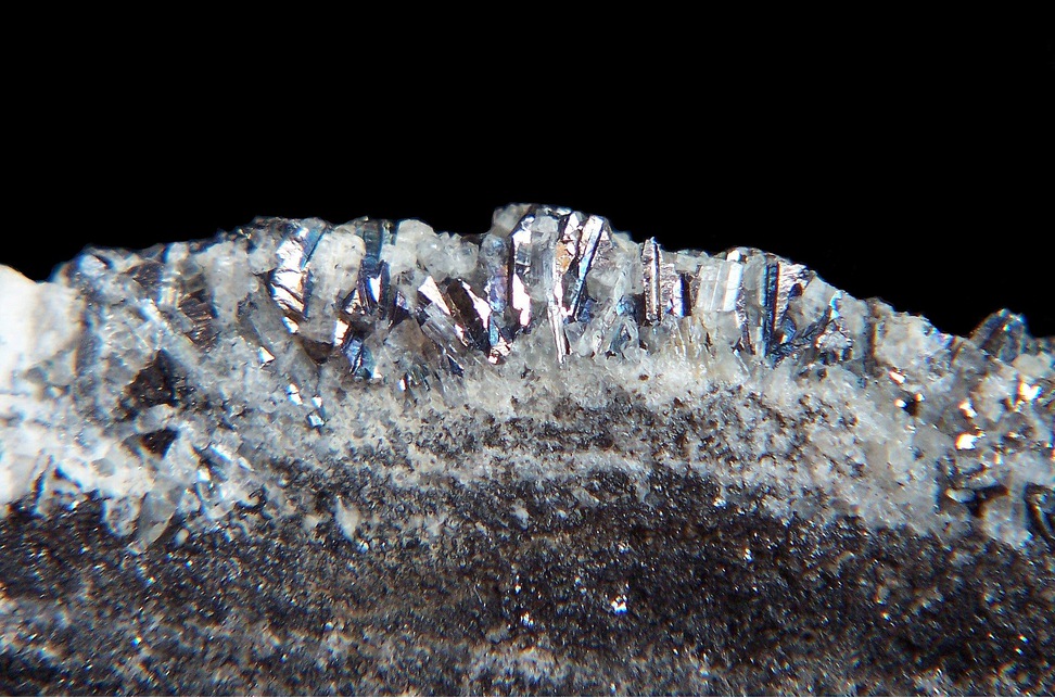


Bismuth Mine, Emmaville, Gough Co., New South Wales, Australia