| Locality | Latitude | Longitude | Distance | Bearing |
|---|
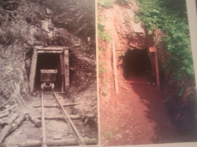
| Seward Bonanza Gold Co.; Kenai Lode Mine, Hope Mining District, Kenai Peninsula Borough, Alaska, USA | 60° 22' 27" N | 149° 19' 58" W | 0.7km (0.4 miles) | |
| Unnamed Occurrence (ARDF - SR203; Andy Simons Mountain), Hope Mining District, Kenai Peninsula Borough, Alaska, USA | 60° 23' 13" N | 149° 17' 56" W | 1.6km (1.0 miles) | |
| Brown Bear Prospect, Hope Mining District, Kenai Peninsula Borough, Alaska, USA | 60° 20' 26" N | 149° 20' 26" W | 4.3km (2.7 miles) | |
| Devil Club Ledge; Lakeside Prospects, Hope Mining District, Kenai Peninsula Borough, Alaska, USA | 60° 19' 36" N | 149° 19' 58" W | 5.8km (3.6 miles) | |
| California-Alaska; Falls Creek Mine, Hope Mining District, Kenai Peninsula Borough, Alaska, USA | 60° 25' 45" N | 149° 16' 40" W | 6.2km (3.9 miles) | |
| Falls Creek Mine, Hope Mining District, Kenai Peninsula Borough, Alaska, USA | 60° 26' 0" N | 149° 20' 20" W | 6.2km (3.9 miles) | |
| Porcupine; Porcupine Gold Mining Co. Occurrence, Hope Mining District, Kenai Peninsula Borough, Alaska, USA | 60° 19' 46" N | 149° 24' 0" W | 6.9km (4.3 miles) | |
| Skeen-Lechner Mine, Hope Mining District, Kenai Peninsula Borough, Alaska, USA | 60° 26' 17" N | 149° 16' 40" W | 7.1km (4.4 miles) | |
| Ballaine and Nelson Occurrence, Hope Mining District, Kenai Peninsula Borough, Alaska, USA | 60° 25' 1" N | 149° 25' 32" W | 7.1km (4.4 miles) | |
| REC 3-9 Occurrence, Hope Mining District, Kenai Peninsula Borough, Alaska, USA | 60° 26' 15" N | 149° 22' 22" W | 7.1km (4.4 miles) | |
| Dunrovin Occurrence, Hope Mining District, Kenai Peninsula Borough, Alaska, USA | 60° 25' 9" N | 149° 13' 10" W | 7.3km (4.5 miles) | |
| Porcupine Creek Occurrence, Seward Mining District, Kenai Peninsula Borough, Alaska, USA | 60° 19' 30" N | 149° 24' 14" W | 7.4km (4.6 miles) | |
| East Point Mine, Hope Mining District, Kenai Peninsula Borough, Alaska, USA | 60° 26' 49" N | 149° 16' 44" W | 8.0km (5.0 miles) | |
| Crown Point; Kenai-Alaska Mine, Hope Mining District, Kenai Peninsula Borough, Alaska, USA | 60° 27' 6" N | 149° 17' 16" W | 8.4km (5.2 miles) | |
| Primrose Mine, Hope Mining District, Kenai Peninsula Borough, Alaska, USA | 60° 18' 33" N | 149° 24' 46" W | 9.1km (5.7 miles) | |
| Porcupine Creek Occurrence, Hope Mining District, Kenai Peninsula Borough, Alaska, USA | 60° 18' 6" N | 149° 26' 48" W | 10.9km (6.8 miles) | |
| Ship Creek Occurrence, Hope Mining District, Kenai Peninsula Borough, Alaska, USA | 60° 22' 22" N | 149° 31' 36" W | 11.2km (7.0 miles) | |
| Solars Occurrence, Hope Mining District, Kenai Peninsula Borough, Alaska, USA | 60° 28' 36" N | 149° 15' 17" W | 11.5km (7.2 miles) | |
| Schoonover; Porcupine Quartz No. 1 Prospect, Hope Mining District, Kenai Peninsula Borough, Alaska, USA | 60° 17' 2" N | 149° 25' 50" W | 12.1km (7.5 miles) | |
| Case; Grant Lake Mine, Hope Mining District, Kenai Peninsula Borough, Alaska, USA | 60° 29' 48" N | 149° 18' 38" W | 13.2km (8.2 miles) | |
| Mizpah Ledge; Kennedy; Pullen; Davis Prospect, Seward Mining District, Kenai Peninsula Borough, Alaska, USA | 60° 15' 59" N | 149° 25' 14" W | 13.6km (8.4 miles) | |
| Unnamed Occurrence (ARDF - SR209; north of Grant Lake), Hope Mining District, Kenai Peninsula Borough, Alaska, USA | 60° 29' 21" N | 149° 13' 10" W | 13.6km (8.4 miles) | |
| Peak 5309 No. 1 Occurrence, Hope Mining District, Kenai Peninsula Borough, Alaska, USA | 60° 20' 20" N | 149° 34' 0" W | 14.1km (8.8 miles) | |
| Grayson Lode, Seward Mining District, Kenai Peninsula Borough, Alaska, USA | 60° 14' 48" N | 149° 25' 8" W | 15.5km (9.7 miles) | |
| Peak 5309 No. 3 Occurrence, Hope Mining District, Kenai Peninsula Borough, Alaska, USA | 60° 20' 40" N | 149° 35' 59" W | 15.7km (9.8 miles) | |
| Peak 5309 No. 2 Occurrence, Hope Mining District, Kenai Peninsula Borough, Alaska, USA | 60° 20' 7" N | 149° 35' 52" W | 15.9km (9.9 miles) | |
| Unnamed Occurrence (ARDF - SR211; above Moose Creek), Hope Mining District, Kenai Peninsula Borough, Alaska, USA | 60° 29' 52" N | 149° 9' 28" W | 16.1km (10.0 miles) | |
| Unnamed Occurrence (ARDF - SR184; Kenai Lake), Hope Mining District, Kenai Peninsula Borough, Alaska, USA | 60° 24' 7" N | 149° 36' 50" W | 16.2km (10.1 miles) | |
| Brewer Alaska; Brewster; Mile Seven; Sevenmile Prospect, Seward Mining District, Kenai Peninsula Borough, Alaska, USA | 60° 13' 41" N | 149° 24' 28" W | 17.3km (10.8 miles) | |
| Homestake Ledge Prospect, Seward Mining District, Kenai Peninsula Borough, Alaska, USA | 60° 13' 24" N | 149° 24' 2" W | 17.7km (11.0 miles) | |


Seward Bonanza Gold Co.; Kenai Lode Mine, Hope Mining District, Kenai Peninsula Borough, Alaska, USA