Thetford Lead Mine, Thetford, Orange County, Vermont, USAi
| Regional Level Types | |
|---|---|
| Thetford Lead Mine | Mine (Abandoned) |
| Thetford | - not defined - |
| Orange County | County |
| Vermont | State |
| USA | Country |
This page is currently not sponsored. Click here to sponsor this page.


Latitude & Longitude (WGS84):
43° 49' 27'' North , 72° 13' 8'' West
Latitude & Longitude (decimal):
Type:
Mine (Abandoned) - last checked 2019
Köppen climate type:
Mindat Locality ID:
308212
Long-form identifier:
mindat:1:2:308212:9
GUID (UUID V4):
7102ce82-9f0e-4cae-b484-ba8161a12929
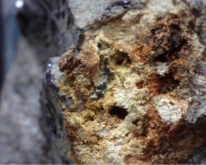
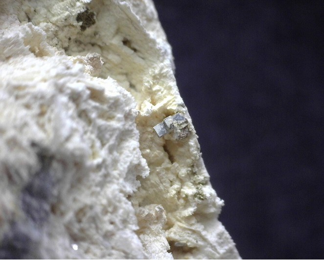
A galena/sphalerite vein occurrence exploited for lead.
Earliest reference to the locality is 1812, when a petition by Israel Newton of Norwich, Vermont states that "...they have discovered various mineral ores in their land...especially rich lead ores..."
By 1824, Zadock Thompson in his Gazetteer of 1824, states "...the ore is rich, yielding 75% of pure lead, but the vein is small, and has been pursued to the depth of 23 feet."
In 1848, a "truck load of bar-lead" from the Thetford mine was on exhibition on State Street in Boston. At this time, "The vein which is now being worked, is from 4 to 25 inches in width...and appears to be inexhaustible."
At its peak, the mine supported a boarding house, ore crusher, and a furnace. A pond - Lead Mine Pond - impounded by a dam, was located just above a washing house. I found one reference to a couple of brothers - Richard and Mitchell Welch - who came from County Waterford, Ireland to work in the mine.
By 1861, a report by the Vermont State Geologist states that a shaft had been sunk to the depth of about a hundred feet. He further states that the vein is thin, and in many places, completely pinched out; further work was unadvisable. He notes that the excavation was filled with water and surrounding buildings were in a state of decay.
Silver values have been reported from the processing of the lead.
Deposit: Discovery year: 1840's occurs as a vein filling in a fractured quartzite in a gangue of quartz and calcite.
Development: Vein proved too irregular to be mined for a profit.
Rock formation(s): Gile Mountain Formation
Select Mineral List Type
Standard Detailed Gallery Strunz Chemical ElementsCommodity List
This is a list of exploitable or exploited mineral commodities recorded at this locality.Mineral List
6 valid minerals.
Rock Types Recorded
Note: data is currently VERY limited. Please bear with us while we work towards adding this information!
Select Rock List Type
Alphabetical List Tree DiagramDetailed Mineral List:
| ⓘ Calcite Formula: CaCO3 |
| ⓘ Chalcopyrite Formula: CuFeS2 |
| ⓘ Galena Formula: PbS |
| ⓘ 'Limonite' |
| ⓘ Quartz Formula: SiO2 |
| ⓘ Siderite Formula: FeCO3 References: |
| ⓘ Sphalerite Formula: ZnS |

List of minerals arranged by Strunz 10th Edition classification
| Group 2 - Sulphides and Sulfosalts | |||
|---|---|---|---|
| ⓘ | Sphalerite | 2.CB.05a | ZnS |
| ⓘ | Chalcopyrite | 2.CB.10a | CuFeS2 |
| ⓘ | Galena | 2.CD.10 | PbS |
| Group 4 - Oxides and Hydroxides | |||
| ⓘ | Quartz | 4.DA.05 | SiO2 |
| Group 5 - Nitrates and Carbonates | |||
| ⓘ | Calcite | 5.AB.05 | CaCO3 |
| ⓘ | Siderite | 5.AB.05 | FeCO3 |
| Unclassified | |||
| ⓘ | 'Limonite' | - | |
List of minerals for each chemical element
| C | Carbon | |
|---|---|---|
| C | ⓘ Calcite | CaCO3 |
| C | ⓘ Siderite | FeCO3 |
| O | Oxygen | |
| O | ⓘ Calcite | CaCO3 |
| O | ⓘ Quartz | SiO2 |
| O | ⓘ Siderite | FeCO3 |
| Si | Silicon | |
| Si | ⓘ Quartz | SiO2 |
| S | Sulfur | |
| S | ⓘ Chalcopyrite | CuFeS2 |
| S | ⓘ Galena | PbS |
| S | ⓘ Sphalerite | ZnS |
| Ca | Calcium | |
| Ca | ⓘ Calcite | CaCO3 |
| Fe | Iron | |
| Fe | ⓘ Chalcopyrite | CuFeS2 |
| Fe | ⓘ Siderite | FeCO3 |
| Cu | Copper | |
| Cu | ⓘ Chalcopyrite | CuFeS2 |
| Zn | Zinc | |
| Zn | ⓘ Sphalerite | ZnS |
| Pb | Lead | |
| Pb | ⓘ Galena | PbS |
Other Databases
| Link to USGS MRDS: | 10081547 |
|---|
Other Regions, Features and Areas containing this locality
North America PlateTectonic Plate
- Ganderia DomainDomain
This page contains all mineral locality references listed on mindat.org. This does not claim to be a complete list. If you know of more minerals from this site, please register so you can add to our database. This locality information is for reference purposes only. You should never attempt to
visit any sites listed in mindat.org without first ensuring that you have the permission of the land and/or mineral rights holders
for access and that you are aware of all safety precautions necessary.
References


Thetford Lead Mine, Thetford, Orange County, Vermont, USA