| Locality | Latitude | Longitude | Distance | Bearing |
|---|
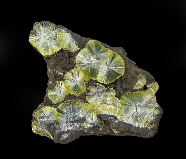
| Ballybunnion, Kerry County, Munster, Ireland | 52° 30' 34" N | 9° 40' 18" W | 0.0km (0.0 miles) | |
| Leamnamucka, Doon East, Ballybunnion, Kerry County, Munster, Ireland | 52° 31' 57" N | 9° 40' 15" W | 2.5km (1.6 miles) | |
| Crataloe Colliery, Limerick County, Munster, Ireland | 52° 25' 34" N | 9° 14' 50" W | 30.2km (18.8 miles) | |
| Rocklodge Colliery, Limerick County, Munster, Ireland | 52° 35' 9" N | 9° 14' 9" W | 30.7km (19.1 miles) | |
| Ballyegan Quarry, Castleisland, Kerry County, Munster, Ireland | 52° 14' 39" N | 9° 31' 35" W | 31.1km (19.3 miles) | |
| Dromtrasna Colliery, Limerick County, Munster, Ireland | 52° 22' 56" N | 9° 13' 58" W | 32.9km (20.5 miles) | |
| Carrowbane Colliery, Limerick County, Munster, Ireland | 52° 35' 6" N | 9° 11' 42" W | 33.3km (20.7 miles) | |
| Tulligoline Colliery, Limerick County, Munster, Ireland | 52° 24' 56" N | 9° 12' 2" W | 33.6km (20.9 miles) | |
| Coalhill Colliery, Limerick County, Munster, Ireland | 52° 35' 52" N | 9° 11' 22" W | 34.0km (21.2 miles) | |
| Knockaboula Colliery, Limerick County, Munster, Ireland | 52° 35' 12" N | 9° 10' 3" W | 35.2km (21.9 miles) | |
| Sugarhill Colliery, Limerick County, Munster, Ireland | 52° 26' 14" N | 9° 9' 20" W | 35.9km (22.3 miles) | |
| Grouse Lodge Quarry, Ardagh, Limerick County, Munster, Ireland | 52° 31' 31" N | 9° 6' 7" W | 38.6km (24.0 miles) | |
| Fort Lismeenagh (Ballycormick), Shanagolden, Limerick County, Munster, Ireland | 52° 33' 57" N | 9° 6' 11" W | 39.0km (24.2 miles) | |
| Lisgordan, Ardagh, Limerick County, Munster, Ireland | 52° 31' 14" N | 9° 3' 26" W | 41.6km (25.8 miles) | |
| Cahermoyle, Ardagh, Limerick County, Munster, Ireland | 52° 30' 37" N | 9° 3' 11" W | 41.9km (26.0 miles) | |
| Courtbrown Zn-Pb deposit, Askeaton, Limerick County, Munster, Ireland | 52° 38' 15" N | 8° 59' 39" W | 47.9km (29.8 miles) | |
| Askeaton, Limerick County, Munster, Ireland | 52° 36' 0" N | 8° 58' 37" W | 48.0km (29.8 miles) | |
| Ross Island, Lough Leane, Killarney, Kerry County, Munster, Ireland | 52° 2' 5" N | 9° 32' 13" W | 53.6km (33.3 miles) | |
| Muckross Mine, Killarney, Kerry County, Munster, Ireland | 52° 0' 56" N | 9° 31' 55" W | 55.7km (34.6 miles) | |
| Doolin Phosphate Mine, Lisdoonvarna, The Burren, Clare County, Munster, Ireland | 53° 1' 0" N | 9° 21' 54" W | 60.1km (37.3 miles) | |
| Doolin Fluorspar Mine, Lisdoonvarna, The Burren, Clare County, Munster, Ireland | 53° 1' 18" N | 9° 23' 14" W | 60.1km (37.3 miles) | |
| Roadford, The Burren, Clare County, Munster, Ireland | 53° 1' 9" N | 9° 22' 17" W | 60.1km (37.4 miles) | |
| Doolin Silver Mine, Lisdoonvarna, The Burren, Clare County, Munster, Ireland | 53° 1' 27" N | 9° 23' 26" W | 60.3km (37.4 miles) | |
| Limerick meteorite, Limerick County, Munster, Ireland | 52° 34' 0" N | 8° 46' 59" W | 60.4km (37.6 miles) | |
| Drominagh Colliery, The Municipal District of Kanturk – Mallow, Cork County, Munster, Ireland | 52° 7' 53" N | 9° 0' 39" W | 61.5km (38.2 miles) | |
| Lisnacon Colliery, The Municipal District of Kanturk – Mallow, Cork County, Munster, Ireland | 52° 8' 2" N | 8° 58' 45" W | 62.9km (39.1 miles) | |
| Drumskehey Colliery, The Municipal District of Kanturk – Mallow, Cork County, Munster, Ireland | 52° 7' 37" N | 8° 59' 8" W | 63.1km (39.2 miles) | |
| Crossard Quarry, Corofin, The Burren, Clare County, Munster, Ireland | 52° 57' 55" N | 9° 6' 43" W | 63.1km (39.2 miles) | |
| Dromagh Colliery, The Municipal District of Kanturk – Mallow, Cork County, Munster, Ireland | 52° 7' 38" N | 8° 58' 55" W | 63.3km (39.3 miles) | |
| Corofin, The Burren, Clare County, Munster, Ireland | 52° 56' 43" N | 9° 3' 42" W | 63.5km (39.5 miles) | |
Minerals recorded nearby (within 20 km)
Rock types recorded nearby (within 20 km)
Entries shown in red are rocks recorded for this region.


Ballybunnion, Kerry County, Munster, Ireland