| Locality | Latitude | Longitude | Distance | Bearing |
|---|
| Copper Blossom MS 3664 claim, San Carlos area, Gila County, Arizona, USA | 33° 21' 23" N | 110° 31' 0" W | 0.0km (0.0 miles) | |
| Iron claims, San Carlos area, Gila County, Arizona, USA | 33° 20' 40" N | 110° 30' 51" W | 1.3km (0.8 miles) | |
| San Carlos Gypsum deposit (San Carlos deposit), San Carlos Basin, San Carlos area, Gila County, Arizona, USA | 33° 20' 17" N | 110° 30' 6" W | 2.5km (1.5 miles) | |
| Unnamed pumice deposit, San Carlos, Gila County, Arizona, USA | 33° 21' 55" N | 110° 28' 50" W | 3.5km (2.2 miles) | |
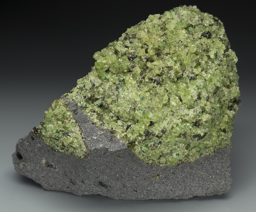
| Peridot Mesa (Peridot occurrence 38), San Carlos, Gila County, Arizona, USA | 33° 19' 49" N | 110° 29' 35" W | 3.6km (2.3 miles) | |
| Tufa Quarry, San Carlos area, Gila County, Arizona, USA | 33° 22' 32" N | 110° 28' 28" W | 4.4km (2.8 miles) | |
| Peacock claims, Bucket Mountain area, Gila County, Arizona, USA | 33° 19' 0" N | 110° 32' 47" W | 5.2km (3.2 miles) | |
| Rice Station School, Tolklai, Gila County, Arizona, USA | 33° 21' 21" N | 110° 27' 7" W | 6.0km (3.7 miles) | |
| San Carlos, Gila County, Arizona, USA | 33° 20' 43" N | 110° 27' 9" W | 6.1km (3.8 miles) | |
| Bucket Mountain prospect, Bucket Mountain area, Gila County, Arizona, USA | 33° 19' 0" N | 110° 34' 0" W | 6.4km (4.0 miles) | |
| Unnamed iron prospect, Bucket Mountain area, Hayes Mountains, Gila County, Arizona, USA | 33° 18' 1" N | 110° 33' 28" W | 7.3km (4.5 miles) | |
| Unnamed silica prospect, Bucket Mountain area, Gila County, Arizona, USA | 33° 17' 53" N | 110° 33' 43" W | 7.7km (4.8 miles) | |
| Skeleton Wash deposit, Skeleton Wash, San Carlos, Gila County, Arizona, USA | 33° 23' 44" N | 110° 26' 39" W | 8.0km (5.0 miles) | |
| Unnamed copper prospect (1), San Carlos area, Gila County, Arizona, USA | 33° 24' 25" N | 110° 27' 11" W | 8.2km (5.1 miles) | |
| Peridot, Gila County, Arizona, USA | 33° 18' 3" N | 110° 27' 30" W | 8.2km (5.1 miles) | |
| Skeleton Wash, San Carlos, Graham County, Arizona, USA | 33° 23' 8" N | 110° 26' 8" W | 8.2km (5.1 miles) | |
| San Carlos Peridot area, Peridot, Gila County, Arizona, USA | 33° 17' 53" N | 110° 27' 29" W | 8.4km (5.2 miles) | |
| San Carlos deposits, Peridot area [Gila County], Graham County, Arizona, USA | 33° 17' 59" N | 110° 26' 22" W | 9.5km (5.9 miles) | |
| Apache Mine (Apache claims; Shanley Apache Mine; Metate Asbestos Corp. Mine; Metate Asbestos Corp. claims; Apache claims MS 3996; Apache Mine property), Apache Ridge, Gila County, Arizona, USA | 33° 24' 41" N | 110° 36' 20" W | 10.3km (6.4 miles) | |
| Unnamed Asbestos prospect (7), Talkalai Lake area, Gila County, Arizona, USA | 33° 25' 18" N | 110° 24' 56" W | 11.8km (7.4 miles) | |
| Oak Creek deposit, Oak Creek, San Carlos area, Gila County, Arizona, USA | 33° 25' 29" N | 110° 25' 0" W | 12.0km (7.5 miles) | |
| Chiricahua group of claims (Chiricahua prospect; Chiricahua deposit), Hog Mountain area, Hayes Mountains, Gila County, Arizona, USA | 33° 16' 23" N | 110° 36' 29" W | 12.6km (7.8 miles) | |
| Mystery group of claims (Mystery prospect), Hog Mountain area, Hayes Mountains, Gila County, Arizona, USA | 33° 16' 8" N | 110° 36' 46" W | 13.2km (8.2 miles) | |
| Silver Bell group MS 3698 claims, Hog Mountain area, Hayes Mountains, Gila County, Arizona, USA | 33° 16' 59" N | 110° 39' 38" W | 15.7km (9.7 miles) | |
| Unnamed asbestos prospect (3), Red Whiskers Spring, Hog Mountain area, Hayes Mountains, Gila County, Arizona, USA | 33° 14' 48" N | 110° 37' 54" W | 16.2km (10.1 miles) | |
| San Carlos Indian Reservation deposit, Graham County, Arizona, USA | 33° 17' 57" N | 110° 21' 11" W | 16.5km (10.2 miles) | |
| Soda Springs (Soda Spring), Gila County, Arizona, USA | 33° 12' 27" N | 110° 32' 8" W | 16.6km (10.3 miles) | |
| Triplets Wash, Graham County, Arizona, USA | 33° 17' 30" N | 110° 21' 15" W | 16.7km (10.4 miles) | |
| Black Mesa prospect (Black Mesa deposit), Cassadore Spring area, Black Mesa area, Gila County, Arizona, USA | 33° 29' 2" N | 110° 24' 56" W | 17.0km (10.6 miles) | |
| Hayes Mountains, Gila County, Arizona, USA | 33° 12' 42" N | 110° 36' 29" W | 18.2km (11.3 miles) | |


Peridot Mesa, San Carlos, Gila County, Arizona, USA