| Locality | Latitude | Longitude | Distance | Bearing |
|---|
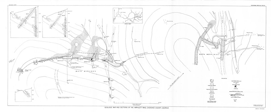
| Amphlett Mica Mine (Franklin Mine), Ball Ground, Ball Ground Mining District, Cherokee County, Georgia, USA | 34° 20' 0" N | 84° 18' 0" W | 0.0km (0.0 miles) | |
| South Amphlett prospect, Cherokee County, Georgia, USA | 34° 19' 53" N | 84° 18' 6" W | 0.3km (0.2 miles) | |
| Conn's Creek School, Cherokee County, Georgia, USA | 34° 20' 18" N | 84° 18' 14" W | 0.7km (0.4 miles) | |
| Conn Church, Cherokee County, Georgia, USA | 34° 20' 19" N | 84° 18' 16" W | 0.7km (0.4 miles) | |
| Cochran Mine, Ball Ground, Ball Ground Mining District, Cherokee County, Georgia, USA | 34° 20' 36" N | 84° 19' 51" W | 3.0km (1.9 miles) | |
| Franklin-Creighton Mine (Creighton Mine; Standard Mine), Ball Ground, Ball Ground Mining District, Cherokee County, Georgia, USA | 34° 18' 42" N | 84° 15' 59" W | 3.9km (2.4 miles) | |
| Shiloh Church, Cherokee County, Georgia, USA | 34° 21' 3" N | 84° 15' 42" W | 4.0km (2.5 miles) | |
| Creighton Mine, Ball Ground, Ball Ground Mining District, Cherokee County, Georgia, USA | 34° 18' 0" N | 84° 16' 59" W | 4.0km (2.5 miles) | |
| Cox Prospect, Cherokee County, Georgia, USA | 34° 17' 48" N | 84° 17' 51" W | 4.1km (2.5 miles) | |
| S. S. Densmore prospect, Cherokee County, Georgia, USA | 34° 22' 21" N | 84° 18' 27" W | 4.4km (2.7 miles) | |
| Reevis mica prospect, Ball Ground, Ball Ground Mining District, Cherokee County, Georgia, USA | 34° 22' 7" N | 84° 19' 27" W | 4.5km (2.8 miles) | |
| F. M. Williams prospect, Cherokee County, Georgia, USA | 34° 19' 9" N | 84° 20' 57" W | 4.8km (3.0 miles) | |
| Fourmile Church, Cherokee County, Georgia, USA | 34° 22' 44" N | 84° 18' 38" W | 5.2km (3.2 miles) | |
| Lot 296, Cherokee County, Georgia, USA | 34° 22' 25" N | 84° 20' 34" W | 5.9km (3.7 miles) | |
| Hendrix Mine, Ball Ground, Ball Ground Mining District, Cherokee County, Georgia, USA | 34° 19' 59" N | 84° 22' 0" W | 6.1km (3.8 miles) | |
| Grady Holbert Property (Grady Holbery Property), Cherokee County, Georgia, USA | 34° 21' 44" N | 84° 21' 24" W | 6.1km (3.8 miles) | |
| Fowler & Freeman Prospects, Longswamp Creek, Jasper, Pickens County, Georgia, USA | 34° 22' 55" N | 84° 20' 3" W | 6.3km (3.9 miles) | |
| Marble Deposit Unnamed, Cherokee County, Georgia, USA | 34° 22' 30" N | 84° 20' 49" W | 6.3km (3.9 miles) | |
| Keithsburg Marble Belt, Ball Ground, Ball Ground Mining District, Cherokee County, Georgia, USA | 34° 22' 30" N | 84° 20' 49" W | 6.3km (3.9 miles) | |
| Burty No. 1 Mine (Richards), Cherokee County, Georgia, USA | 34° 23' 5" N | 84° 19' 55" W | 6.4km (4.0 miles) | |
| S. R. Smith Mine, Cherokee County, Georgia, USA | 34° 16' 51" N | 84° 19' 56" W | 6.6km (4.1 miles) | |
| Andrew Satterfield Prospect, Cherokee County, Georgia, USA | 34° 19' 58" N | 84° 22' 20" W | 6.6km (4.1 miles) | |
| Ball Ground, Ball Ground Mining District, Cherokee County, Georgia, USA | 34° 20' 17" N | 84° 22' 35" W | 7.0km (4.4 miles) | |
| Unnamed Barium Deposit (10144117), Cherokee County, Georgia, USA | 34° 16' 12" N | 84° 17' 11" W | 7.2km (4.5 miles) | |
| Walker Mine, Pickens County, Georgia, USA | 34° 23' 55" N | 84° 18' 8" W | 7.3km (4.5 miles) | |
| L. L. Spence Property, Cherokee County, Georgia, USA | 34° 20' 39" N | 84° 22' 44" W | 7.4km (4.6 miles) | |
| Bozeman Mine (Jones Mine), Tate, Pickens County, Georgia, USA | 34° 23' 33" N | 84° 20' 26" W | 7.6km (4.7 miles) | |
| Burleson Mine, Pickens County, Georgia, USA | 34° 23' 37" N | 84° 20' 37" W | 7.8km (4.9 miles) | |
| L. L. Spence Property (2), Cherokee County, Georgia, USA | 34° 20' 26" N | 84° 23' 11" W | 8.0km (4.9 miles) | |
| Federal School, Pickens County, Georgia, USA | 34° 24' 4" N | 84° 19' 51" W | 8.0km (5.0 miles) | |

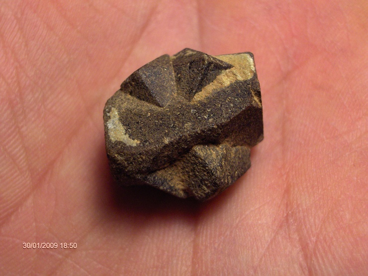
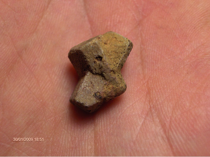


Amphlett Mica Mine, Ball Ground, Ball Ground Mining District, Cherokee County, Georgia, USA