Home PageAbout MindatThe Mindat ManualHistory of MindatCopyright StatusWho We AreContact UsAdvertise on Mindat
Donate to MindatCorporate SponsorshipSponsor a PageSponsored PagesMindat AdvertisersAdvertise on Mindat
Learning CenterWhat is a mineral?The most common minerals on earthInformation for EducatorsMindat ArticlesThe ElementsThe Rock H. Currier Digital LibraryGeologic Time
Minerals by PropertiesMinerals by ChemistryAdvanced Locality SearchRandom MineralRandom LocalitySearch by minIDLocalities Near MeSearch ArticlesSearch GlossaryMore Search Options
The Mindat ManualAdd a New PhotoRate PhotosLocality Edit ReportCoordinate Completion ReportAdd Glossary Item
Mining CompaniesStatisticsUsersMineral MuseumsClubs & OrganizationsMineral Shows & EventsThe Mindat DirectoryDevice SettingsThe Mineral Quiz
Photo SearchPhoto GalleriesSearch by ColorNew Photos TodayNew Photos YesterdayMembers' Photo GalleriesPast Photo of the Day GalleryPhotography
Cordillera Septentrional, Santiago Province, Dominican Republici
| Regional Level Types | |
|---|---|
| Cordillera Septentrional | Mountain Range |
| Santiago Province | Province |
| Dominican Republic | Country |
This page is currently not sponsored. Click here to sponsor this page.

Type:
Largest Settlements:
| Place | Population |
|---|---|
| Río Grande | 20,154 (2016) |
| Monte Llano | 19,029 (2018) |
| Salsipuedes | 11,675 (2016) |
| Imbert | 8,024 (2016) |
| Tenares | 7,390 (2016) |
| Gaspar Hernández | 6,506 (2016) |
Mindat Locality ID:
108104
Long-form identifier:
mindat:1:2:108104:9
GUID (UUID V4):
b9070eed-f0cc-44f0-b368-a48d019d559c
Other Languages:
Spanish:
Cordillera Septentrional, Santiago, República Dominicana
Cebuano:
Cordillera Septentrional, Provincia de Santiago
Dutch:
Cordillera Septentrional, Santiago, Dominicaanse Republiek
Swedish:
Cordillera Septentrional, Santiago, Dominikanska republiken
Numerous prospects over a large mountain range in different rock types. Known for lignite beds, volcanic rocks, etc.
The Cordillera Septentrional is a mountain range that runs parallel to the north coast of the Dominican Republic, with extensions to the northwest as Tortuga island in Haiti, and to the southeast through lowlands to where it rises as the Sierra de Samaná on the Samaná Peninsula.
The range's highest point is Diego de Ocampo mountain at 1,250 metres (4,100 ft), located near Santiago de los Caballeros in Santiago Province.
There are several small plains between the range and the Atlantic Ocean coastline. Rivers have short courses in the range, and most of them flow to the north into the Atlantic.
Select Mineral List Type
Standard Detailed Gallery Strunz Chemical ElementsDetailed Mineral List:
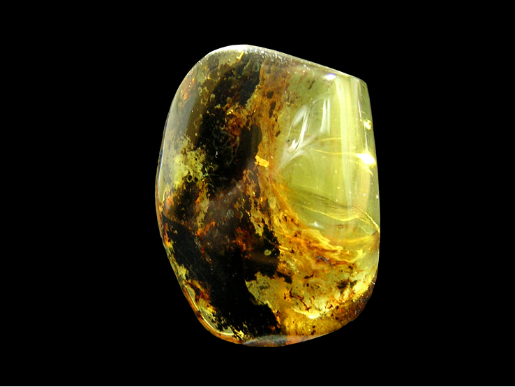
| ⓘ 'Amber' |
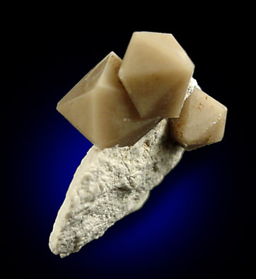
| ⓘ Calcite Formula: CaCO3 References: |
| ⓘ Gypsum Formula: CaSO4 · 2H2O References: |
| ⓘ Quartz Formula: SiO2 References: |

List of minerals arranged by Strunz 10th Edition classification
| Group 4 - Oxides and Hydroxides | |||
|---|---|---|---|
| ⓘ | Quartz | 4.DA.05 | SiO2 |
| Group 5 - Nitrates and Carbonates | |||
| ⓘ | Calcite | 5.AB.05 | CaCO3 |
| Group 7 - Sulphates, Chromates, Molybdates and Tungstates | |||
| ⓘ | Gypsum | 7.CD.40 | CaSO4 · 2H2O |
| Unclassified | |||
| ⓘ | 'Amber' | - | |
List of minerals for each chemical element
| H | Hydrogen | |
|---|---|---|
| H | ⓘ Gypsum | CaSO4 · 2H2O |
| C | Carbon | |
| C | ⓘ Calcite | CaCO3 |
| O | Oxygen | |
| O | ⓘ Calcite | CaCO3 |
| O | ⓘ Gypsum | CaSO4 · 2H2O |
| O | ⓘ Quartz | SiO2 |
| Si | Silicon | |
| Si | ⓘ Quartz | SiO2 |
| S | Sulfur | |
| S | ⓘ Gypsum | CaSO4 · 2H2O |
| Ca | Calcium | |
| Ca | ⓘ Calcite | CaCO3 |
| Ca | ⓘ Gypsum | CaSO4 · 2H2O |
Fossils
There are 9 fossil localities from the PaleoBioDB database within this region.BETA TEST - These data are provided on an experimental basis and are taken from external databases. Mindat.org has no control currently over the accuracy of these data.
Other Databases
| Wikipedia: | https://en.wikipedia.org/wiki/Cordillera_Septentrional |
|---|---|
| Wikidata ID: | Q2049917 |
| GeoNames ID: | 3492814 |
Other Regions, Features and Areas that Intersect
Caribbean PlateTectonic Plate
This page contains all mineral locality references listed on mindat.org. This does not claim to be a complete list. If you know of more minerals from this site, please register so you can add to our database. This locality information is for reference purposes only. You should never attempt to
visit any sites listed in mindat.org without first ensuring that you have the permission of the land and/or mineral rights holders
for access and that you are aware of all safety precautions necessary.


Mindat.org is an outreach project of the Hudson Institute of Mineralogy, a 501(c)(3) not-for-profit organization.
Copyright © mindat.org and the Hudson Institute of Mineralogy 1993-2024, except where stated. Most political location boundaries are © OpenStreetMap contributors. Mindat.org relies on the contributions of thousands of members and supporters. Founded in 2000 by Jolyon Ralph.
Privacy Policy - Terms & Conditions - Contact Us / DMCA issues - Report a bug/vulnerability Current server date and time: April 27, 2024 02:47:23 Page updated: March 17, 2024 16:16:40
Cordillera Septentrional, Santiago Province, Dominican Republic