| Locality | Latitude | Longitude | Distance | Bearing |
|---|
| Cameron Quarry, Ramsay Township, Lanark County, Ontario, Canada | 45° 9' 20" N | 76° 13' 4" W | 8.9km (5.5 miles) | |
| Highway 7 Roadcut, Carleton Place, Lanark County, Ontario, Canada | 45° 7' 56" N | 76° 11' 0" W | 11.5km (7.1 miles) | |
| Ramsay Mine, Ramsay Township, Lanark County, Ontario, Canada | 45° 9' 10" N | 76° 9' 59" W | 12.9km (8.0 miles) | |
| Tatlock Quarry, Lanark County, Ontario, Canada | 45° 9' 2" N | 76° 29' 45" W | 13.1km (8.2 miles) | |
| Cedar Hill soapstone occurrence, Pakenham Township, Ottawa, Ontario, Canada | 45° 16' 1" N | 76° 19' 39" W | 14.1km (8.8 miles) | |
| Playfair Mine (Dalhousie Mine; Lanark Iron Mine), Dalhousie Township, Lanark County, Ontario, Canada | 44° 58' 24" N | 76° 25' 44" W | 20.1km (12.5 miles) | |
| Darling hematite occurrence (Bell's mine; Eggshell Bay), Darling Township, Lanark County, Ontario, Canada | 45° 17' 0" N | 76° 30' 24" W | 21.1km (13.1 miles) | |
| Ennis Quarry, Bathurst Township, Lanark County, Ontario, Canada | 44° 56' 49" N | 76° 22' 41" W | 21.8km (13.6 miles) | |
| Perth quarry, Bathurst Township, Lanark County, Ontario, Canada | 44° 56' 22" N | 76° 22' 47" W | 22.7km (14.1 miles) | |
| Keays Quarry, Bathurst Township, Lanark County, Ontario, Canada | 44° 56' 21" N | 76° 23' 3" W | 22.8km (14.2 miles) | |
| Yuill Mine, Darling Township, Lanark County, Ontario, Canada | 45° 14' 7" N | 76° 35' 42" W | 23.4km (14.5 miles) | |
| Currie Barite occurrence, Fitzroy Township, Ottawa, Ontario, Canada | 45° 19' 53" N | 76° 10' 48" W | 24.2km (15.1 miles) | |
| Bathurst Feldspar Mines Ltd, Bathurst Township, Lanark County, Ontario, Canada | 44° 54' 39" N | 76° 24' 23" W | 26.2km (16.3 miles) | |
| Radenhurst Mine, Lavant Township, Lanark County, Ontario, Canada | 45° 10' 4" N | 76° 40' 18" W | 27.0km (16.8 miles) | |
| Caldwell Mine, Lavant Township, Lanark County, Ontario, Canada | 45° 10' 2" N | 76° 40' 19" W | 27.1km (16.8 miles) | |
| Perth area, Lanark County, Ontario, Canada | 44° 53' 57" N | 76° 14' 53" W | 27.6km (17.1 miles) | |
| Foster Quarry, Bathurst Township, Lanark County, Ontario, Canada | 44° 53' 57" N | 76° 25' 0" W | 27.7km (17.2 miles) | |
| Blithfield mine (Caldwell mine), Blithfield Township, Greater Madawaska, Renfrew County, Ontario, Canada | 45° 12' 47" N | 76° 40' 27" W | 28.2km (17.5 miles) | |
| Foley Mine, Bathurst Township, Lanark County, Ontario, Canada | 44° 53' 35" N | 76° 25' 10" W | 28.4km (17.6 miles) | |
| Virgin Lake celestine mine (Dempseys), Bagot Township, Greater Madawaska, Renfrew County, Ontario, Canada | 45° 15' 47" N | 76° 39' 47" W | 29.5km (18.3 miles) | |
| High Falls area, Lanark County, Ontario, Canada | 44° 57' 12" N | 76° 37' 23" W | 31.1km (19.3 miles) | |
| Clyde Forks Mine, Lavant Township, Lanark County, Ontario, Canada | 45° 7' 26" N | 76° 43' 33" W | 31.2km (19.4 miles) | |
| Wilbur Mine, Lavant Township, Lanark County, Ontario, Canada | 45° 1' 18" N | 76° 41' 32" W | 31.4km (19.5 miles) | |
| Galetta area, Fitzroy Township, Ottawa, Ontario, Canada | 45° 25' 27" N | 76° 15' 23" W | 32.1km (19.9 miles) | |
| Twenty Six Lake occurrence, Palmerston Township, Frontenac County, Ontario, Canada | 45° 2' 12" N | 76° 43' 0" W | 32.5km (20.2 miles) | |
| Humphreys feldspar mine, Huntley Township, Ottawa, Ontario, Canada | 45° 21' 30" N | 76° 2' 50" W | 32.8km (20.4 miles) | |
| Kirkham Mine, Bathurst Township, Lanark County, Ontario, Canada | 44° 51' 34" N | 76° 27' 51" W | 33.0km (20.5 miles) | |
| Boyce Mine (Kent; Anglo-Canadian; Otty Lake), North Burgess Township, Lanark County, Ontario, Canada | 44° 50' 56" N | 76° 14' 38" W | 33.1km (20.6 miles) | |
| Campbell Drive tremolite occurrence, McNab Township, McNab/Braeside, Renfrew County, Ontario, Canada | 45° 26' 0" N | 76° 24' 11" W | 33.1km (20.6 miles) | |
| Andrew Lake occurrence, North Burgess Township, Lanark County, Ontario, Canada | 44° 50' 50" N | 76° 14' 43" W | 33.2km (20.7 miles) | |
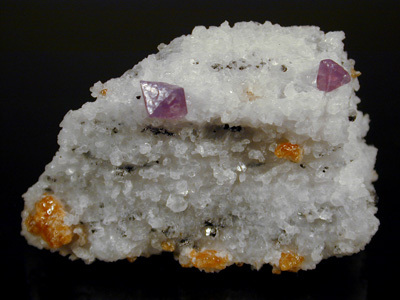
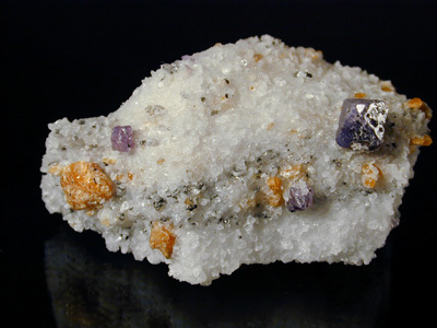
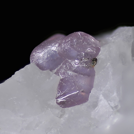


Cameron Quarry, Ramsay Township, Lanark County, Ontario, Canada