| Locality | Latitude | Longitude | Distance | Bearing |
|---|
| Charlotten Mine, Catterfeld, Georgenthal, Gotha District, Thuringia, Germany | 50° 50' 26" N | 10° 38' 17" E | 3.0km (1.8 miles) | |
| Catterfeld, Georgenthal, Gotha District, Thuringia, Germany | 50° 50' 19" N | 10° 38' 6" E | 3.1km (1.9 miles) | |
| Glücksstern Mine, Gottlob Hill, Friedrichroda, Gotha District, Thuringia, Germany | 50° 51' 6" N | 10° 34' 10" E | 3.9km (2.4 miles) | |
| Gottlob Hill, Friedrichroda, Gotha District, Thuringia, Germany | 50° 51' 4" N | 10° 33' 49" E | 4.3km (2.6 miles) | |
| Melaphyre outcrop, Georgenthal, Gotha District, Thuringia, Germany | 50° 49' 36" N | 10° 38' 51" E | 4.6km (2.9 miles) | |
| Tannenkopf mining field, Friedrichroda, Gotha District, Thuringia, Germany | 50° 51' 28" N | 10° 32' 32" E | 5.5km (3.4 miles) | |
| Marienglas cave, Friedrichroda, Gotha District, Thuringia, Germany | 50° 51' 45" N | 10° 32' 29" E | 5.6km (3.5 miles) | |
| Seebach Cliff, Friedrichroda, Gotha District, Thuringia, Germany | 50° 50' 2" N | 10° 32' 12" E | 6.8km (4.2 miles) | |
| Tabarz meteorite, Bad Tabarz, Gotha District, Thuringia, Germany | 50° 52' 59" N | 10° 31' 0" E | 7.6km (4.7 miles) | |
| Tabarz quarry, Bad Tabarz, Gotha District, Thuringia, Germany | 50° 52' 1" N | 10° 29' 28" E | 9.1km (5.6 miles) | |
| Steiniger Berg, Luisenthal, Gotha District, Thuringia, Germany | 50° 47' 29" N | 10° 43' 6" E | 10.7km (6.6 miles) | |
| Goldberg, Ohrdruf, Gotha District, Thuringia, Germany | 50° 48' 52" N | 10° 45' 4" E | 10.7km (6.7 miles) | |
| Kienberg, Luisenthal, Gotha District, Thuringia, Germany | 50° 46' 43" N | 10° 44' 26" E | 12.8km (7.9 miles) | |
| Nesselgrund Quarry, Schnellbach, Floh-Seligenthal, Schmalkalden-Meiningen District, Thuringia, Germany | 50° 45' 56" N | 10° 31' 33" E | 12.9km (8.0 miles) | |
| Rinderberg, Struth-Helmershof, Floh-Seligenthal, Schmalkalden-Meiningen District, Thuringia, Germany | 50° 44' 27" N | 10° 31' 26" E | 15.4km (9.5 miles) | |
| Stahlberg Mine, Seligenthal, Floh-Seligenthal, Schmalkalden-Meiningen District, Thuringia, Germany | 50° 46' 0" N | 10° 27' 34" E | 15.7km (9.8 miles) | |
| Porphyry quarry, Brotterode-Trusetal, Schmalkalden-Meiningen District, Thuringia, Germany | 50° 47' 38" N | 10° 25' 20" E | 16.0km (9.9 miles) | |
| Finstertal mine, Schmalkalden, Schmalkalden-Meiningen District, Thuringia, Germany | 50° 44' 6" N | 10° 30' 16" E | 16.6km (10.3 miles) | |
| Hühn Mine, Trusetal, Brotterode-Trusetal, Schmalkalden-Meiningen District, Thuringia, Germany | 50° 47' 3" N | 10° 25' 19" E | 16.6km (10.3 miles) | |
| Mühlrain, Ruhla, Wartburg District, Thuringia, Germany | 50° 52' 31" N | 10° 22' 53" E | 16.8km (10.4 miles) | |
| Atterode, Bad Liebenstein, Wartburg District, Thuringia, Germany | 50° 49' 20" N | 10° 23' 14" E | 17.0km (10.6 miles) | |
| Herges-Vogtei gypsum mine, Trusetal, Brotterode-Trusetal, Schmalkalden-Meiningen District, Thuringia, Germany | 50° 47' 18" N | 10° 24' 6" E | 17.6km (10.9 miles) | |
| Trusetal, Brotterode-Trusetal, Schmalkalden-Meiningen District, Thuringia, Germany | 50° 47' 2" N | 10° 24' 16" E | 17.6km (11.0 miles) | |
| Lütschegrund mine, Frankenhain, Ilm District, Thuringia, Germany | 50° 44' 12" N | 10° 46' 21" E | 17.8km (11.1 miles) | |
| Kochenfeld Mine, Trusetal, Brotterode-Trusetal, Schmalkalden-Meiningen District, Thuringia, Germany | 50° 47' 44" N | 10° 23' 28" E | 17.8km (11.1 miles) | |
| Mommel Mine, Trusetal, Brotterode-Trusetal, Schmalkalden-Meiningen District, Thuringia, Germany | 50° 47' 13" N | 10° 23' 47" E | 18.0km (11.2 miles) | |
| Bergmannskopf, Gräfenroda, Geratal, Ilm District, Thuringia, Germany | 50° 44' 17" N | 10° 47' 1" E | 18.2km (11.3 miles) | |
| Steinbach, Bad Liebenstein, Wartburg District, Thuringia, Germany | 50° 50' 0" N | 10° 21' 49" E | 18.4km (11.4 miles) | |
| Schmidt quarry (Engestieg quarry), Ruhla, Wartburg District, Thuringia, Germany | 50° 53' 11" N | 10° 21' 33" E | 18.5km (11.5 miles) | |
| Dörrberg, Gräfenroda, Geratal, Ilm District, Thuringia, Germany | 50° 43' 46" N | 10° 47' 48" E | 19.5km (12.1 miles) | |


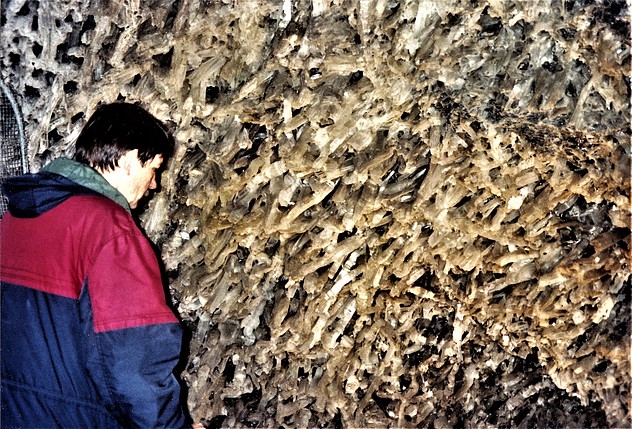


Marienglas cave, Friedrichroda, Gotha District, Thuringia, Germany