Lincoln County, Wyoming, USAi
| Regional Level Types | |
|---|---|
| Lincoln County | County |
| Wyoming | State |
| USA | Country |
This page is currently not sponsored. Click here to sponsor this page.


Type:
Largest Settlements:
| Place | Population |
|---|---|
| Kemmerer | 2,739 (2017) |
| Afton | 1,972 (2017) |
| Star Valley Ranch | 1,548 (2017) |
| Alpine | 850 (2017) |
| Diamondville | 738 (2017) |
| La Barge | 553 (2017) |
Mindat Locality ID:
171302
Long-form identifier:
mindat:1:2:171302:5
GUID (UUID V4):
3fa12474-f93c-4b79-9fe2-decfa0a392ca
Other Languages:
French:
comté de Lincoln, Wyoming, États-Unis
German:
Lincoln County, Wyoming, Vereinigte Staaten
Italian:
contea di Lincoln, Wyoming, Stati Uniti d'America
Russian:
Линкольн, Вайоминг, Соединённые Штаты Америки
Simplified Chinese:
林肯縣, 怀俄明州, 美国
Spanish:
Condado de Lincoln, Wyoming, Estados Unidos
Albanian:
Lincoln County, Wyoming, Shtetet e Bashkuara të Amerikës
Arabic:
مقاطعة لينكون, وايومنغ, الولايات المتحدة
Azeri:
Linkoln , Vayominq, Amerika Birləşmiş Ştatları
Basque:
Lincoln konderria , Wyoming
Bavarian:
Lincoln County, Wyoming, Vaoanigte Stootn
Bishnupriya Manipuri:
লিঙ্কন কাউন্টি, ৱাইওমিং, তিলপারাষ্ট্র
Bulgarian:
Линкълн, Уайоминг, Съединени американски щати
Cebuano:
Lincoln County , Wyoming
Czech:
Lincoln County, Wyoming, Spojené státy americké
Dutch:
Lincoln County, Wyoming, Verenigde Staten
Estonian:
Lincolni maakond, Wyoming, Ameerika Ühendriigid
Farsi/Persian:
شهرستان لینکلن، وایومینگ, وایومینگ, ایالات متحده آمریکا
Hungarian:
Lincoln megye, Wyoming, Amerikai Egyesült Államok
Japanese:
リンカーン郡, ワイオミング州, アメリカ合衆国
Latin:
Lincoln Comitatus, Vyomina, Civitates Foederatae Americae
Low Saxon/Low German:
Lincoln County, Wyoming, USA
Min Dong Chinese:
Lincoln Gông, Wyoming
Minnan / Hokkien-Taiwanese:
Lincoln Kūn
Norwegian:
Lincoln County, Wyoming, USA
Polish:
Hrabstwo Lincoln, Wyoming, Stany Zjednoczone
Portuguese:
Condado de Lincoln, Wyoming, Estados Unidos
Romanian:
Comitatul Lincoln, Wyoming, Statele Unite ale Americii
Sardinian:
contea de Lincoln, Wyoming, Istados Unidos de Amèrica
Serbian:
Lincoln County, Вајоминг, Сједињене Америчке Државе
Serbo-Croatian:
Lincoln County, Wyoming, Sjedinjene Američke Države
Swedish:
Lincoln County, Wyoming, USA
Traditional Chinese:
林肯縣, 懷俄明州, 美國
Turkish:
Lincoln, Wyoming, Amerika Birleşik Devletleri
Ukrainian:
Лінкольн, Вайомінг, Сполучені Штати Америки
Urdu:
لنکن کاؤنٹی، وائیومنگ, وائیومنگ, ریاستہائے متحدہ امریکا
Vietnamese:
Quận Lincoln, Wyoming, Chủng Quốc Hoa Kỳ
Waray:
Condado han Lincoln, Wyoming, Estados Unidos
No description has been added for this locality. Can you add one?
Select Mineral List Type
Standard Detailed Gallery Strunz Chemical ElementsCommodity List
This is a list of exploitable or exploited mineral commodities recorded from this region.Mineral List
Mineral list contains entries from the region specified including sub-localities11 valid minerals.
Rock Types Recorded
Note: data is currently VERY limited. Please bear with us while we work towards adding this information!
Rock list contains entries from the region specified including sub-localities
Select Rock List Type
Alphabetical List Tree DiagramDetailed Mineral List:
| ⓘ Azurite Formula: Cu3(CO3)2(OH)2 |
| ⓘ Copper Formula: Cu Localities: |
| ⓘ Gold Formula: Au Localities: |
| ⓘ Hematite Formula: Fe2O3 Localities: |
| ⓘ Ilmenite Formula: Fe2+TiO3 |
| ⓘ 'Limonite' |
| ⓘ Malachite Formula: Cu2(CO3)(OH)2 Localities: Reported from at least 7 localities in this region. References: |
| ⓘ Marcasite Formula: FeS2 Habit: Cock's combs |
| ⓘ Molybdenite Formula: MoS2 |
| ⓘ Pyrite Formula: FeS2 Localities: References: |
| ⓘ Quartz Formula: SiO2 |
| ⓘ Sulphur Formula: S8 |

List of minerals arranged by Strunz 10th Edition classification
| Group 1 - Elements | |||
|---|---|---|---|
| ⓘ | Copper | 1.AA.05 | Cu |
| ⓘ | Gold | 1.AA.05 | Au |
| ⓘ | Sulphur | 1.CC.05 | S8 |
| Group 2 - Sulphides and Sulfosalts | |||
| ⓘ | Molybdenite | 2.EA.30 | MoS2 |
| ⓘ | Pyrite | 2.EB.05a | FeS2 |
| ⓘ | Marcasite | 2.EB.10a | FeS2 |
| Group 4 - Oxides and Hydroxides | |||
| ⓘ | Hematite | 4.CB.05 | Fe2O3 |
| ⓘ | Ilmenite | 4.CB.05 | Fe2+TiO3 |
| ⓘ | Quartz | 4.DA.05 | SiO2 |
| Group 5 - Nitrates and Carbonates | |||
| ⓘ | Azurite | 5.BA.05 | Cu3(CO3)2(OH)2 |
| ⓘ | Malachite | 5.BA.10 | Cu2(CO3)(OH)2 |
| Unclassified | |||
| ⓘ | 'Limonite' | - | |
List of minerals for each chemical element
| H | Hydrogen | |
|---|---|---|
| H | ⓘ Azurite | Cu3(CO3)2(OH)2 |
| H | ⓘ Malachite | Cu2(CO3)(OH)2 |
| C | Carbon | |
| C | ⓘ Azurite | Cu3(CO3)2(OH)2 |
| C | ⓘ Malachite | Cu2(CO3)(OH)2 |
| O | Oxygen | |
| O | ⓘ Azurite | Cu3(CO3)2(OH)2 |
| O | ⓘ Hematite | Fe2O3 |
| O | ⓘ Ilmenite | Fe2+TiO3 |
| O | ⓘ Malachite | Cu2(CO3)(OH)2 |
| O | ⓘ Quartz | SiO2 |
| Si | Silicon | |
| Si | ⓘ Quartz | SiO2 |
| S | Sulfur | |
| S | ⓘ Marcasite | FeS2 |
| S | ⓘ Molybdenite | MoS2 |
| S | ⓘ Pyrite | FeS2 |
| S | ⓘ Sulphur | S8 |
| Ti | Titanium | |
| Ti | ⓘ Ilmenite | Fe2+TiO3 |
| Fe | Iron | |
| Fe | ⓘ Hematite | Fe2O3 |
| Fe | ⓘ Ilmenite | Fe2+TiO3 |
| Fe | ⓘ Marcasite | FeS2 |
| Fe | ⓘ Pyrite | FeS2 |
| Cu | Copper | |
| Cu | ⓘ Azurite | Cu3(CO3)2(OH)2 |
| Cu | ⓘ Copper | Cu |
| Cu | ⓘ Malachite | Cu2(CO3)(OH)2 |
| Mo | Molybdenum | |
| Mo | ⓘ Molybdenite | MoS2 |
| Au | Gold | |
| Au | ⓘ Gold | Au |
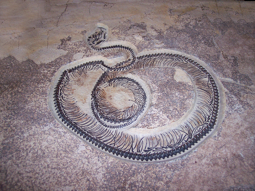
Fossils
There are 123 fossil localities from the PaleoBioDB database within this region.BETA TEST - These data are provided on an experimental basis and are taken from external databases. Mindat.org has no control currently over the accuracy of these data.
| Occurrences | 1388 |
|---|---|
| Youngest Fossil Listed | 1.80 Ma (Pleistocene) |
| Oldest Fossil Listed | 339 Ma (Carboniferous) |
| Stratigraphic Units | Click here to view 32 stratigraphic units. |
| Fossils from Region | Click here to show the list. |
| Fossil Localities | Click to show 123 fossil localities |
- Wyoming
- Lincoln County
- Phanerozoic🐚 'Lingula beds' near Cokeville
- Eocene🐚 Adapiform Tomb
- Permian🐚 AMNH B673
- Early/Lower Triassic🐚 AMNH B7850
- Early/Lower Triassic🐚 AMNH B7854
- Cretaceous🐚 Aspen
- Permian🐚 Basin Creek
- Eocene🐚 Bluffs at head of Twin Creek
- Paleogene🐚 Buckman West 1
- Cenozoic🐚 Chappo Type Locality
- Permian🐚 Cokeville
- Early/Lower Cretaceous🐚 Cokeville eggshell site
- Permian🐚 Cumberland
- Phanerozoic🐚 D-4: D
- Eocene🐚 Finney Quarry
- Eocene🐚 Fish Quarries
- Permian🐚 Fontenelle Creek
- Eocene🐚 Fossil
- Eocene🐚 Fossil Lake Sample Site A-1
- Paleogene🐚 Fossil Lake Sample Site H-1
- Eocene🐚 G-1
- Eocene🐚 Hams Fork
- Eocene🐚 Icaronycteris Type Locality
- Permian🐚 Layland Canyon
- Eocene🐚 Limnofregata type locality
- Paleocene🐚 Little Muddy Creek
- Early/Lower Cretaceous🐚 LJH0026
- Late/Upper Cretaceous🐚 Lower Frontier
- Phanerozoic🐚 McDougal Pass
- Permian🐚 Middle Fork Pine Creek
- Eocene🐚 NE of Opal
- Eocene🐚 NE side Fontanelle Reservoir
- Eocene🐚 Nugget
- Eocene🐚 Opal
- Eocene🐚 Opal [USGS]
- Paleogene🐚 Phareodus testis type locality
- Permian🐚 Raymond Canyon
- Early/Lower Triassic🐚 Swift Creek Canyon
- Early/Lower Triassic🐚 T-9: T
- Early/Lower Cretaceous🐚 Thomas Fork Creek
- Eocene🐚 Tynsky Quarry
- Eocene🐚 UM FB-1
- Eocene🐚 UM FB-10
- Eocene🐚 UM FB-14
- Eocene🐚 UM FB-18
- Eocene🐚 UM FB-22
- Eocene🐚 UM FB-24
- Eocene🐚 UM FB-26
- Eocene🐚 UM FB-27
- Eocene🐚 UM FB-4
- Eocene🐚 UM FB-6
- Eocene🐚 UM FB-7
- Eocene🐚 UM FB-8
- Eocene🐚 UM FB-9
- Late/Upper Cretaceous🐚 Upper Frontier Formation - Lincoln County
- Early/Lower Triassic🐚 USGS 3769 green
- Permian🐚 USGS 5067
- Permian🐚 USGS 5070
- Carboniferous🐚 USGS 6957-PC
- Carboniferous🐚 USGS 6960-PC
- Lincoln County
- Wyoming
- Lincoln County
- Early/Lower Triassic🐚 USGS 7306i green
- Early/Lower Triassic🐚 USGS 7444 green
- Early/Lower Triassic🐚 USGS 7470 green
- Permian🐚 USGS 988h
- Permian🐚 USGS 988i
- Permian🐚 USGS 989
- Middle Jurassic🐚 USGS Mesozoic Loc. 12016 - Twin Creek Limestone
- Middle Jurassic🐚 USGS Mesozoic Loc. 12018 - Twin Creek Limestone
- Middle Jurassic🐚 USGS Mesozoic Loc. 12019
- Middle Jurassic🐚 USGS Mesozoic Loc. 12034 - Twin Creek Limestone
- Middle Jurassic🐚 USGS Mesozoic Loc. 12119 - Twin Creek Limestone
- Middle Jurassic🐚 USGS Mesozoic Loc. 16058 - Twin Creek Limestone
- Middle Jurassic🐚 USGS Mesozoic Loc. 17294 - Twin Creek Limestone
- Middle Jurassic🐚 USGS Mesozoic Loc. 17815 - Twin Creek Limestone
- Middle Jurassic🐚 USGS Mesozoic Loc. 20344 - Twin Creek Limestone
- Middle Jurassic🐚 USGS Mesozoic Loc. 20345 - Twin Creek Limestone
- Middle Jurassic🐚 USGS Mesozoic Loc. 20346 - Twin Creek Limestone
- Middle Jurassic🐚 USGS Mesozoic Loc. 20347 - Twin Creek Limestone
- Middle Jurassic🐚 USGS Mesozoic Loc. 20350 - Twin Creek Limestone
- Middle Jurassic🐚 USGS Mesozoic Loc. 20961 - Twin Creek Limestone
- Middle Jurassic🐚 USGS Mesozoic Loc. 20965 - Twin Creek Limestone
- Middle Jurassic🐚 USGS Mesozoic Loc. 20966 - Twin Creek Limestone
- Middle Jurassic🐚 USGS Mesozoic Loc. 20968 - Twin Creek Limestone
- Middle Jurassic🐚 USGS Mesozoic Loc. 20969 - Twin Creek Limestone
- Middle Jurassic🐚 USGS Mesozoic Loc. 20971 - Twin Creek Limestone
- Middle Jurassic🐚 USGS Mesozoic Loc. 20972 - Twin Creek Limestone
- Middle Jurassic🐚 USGS Mesozoic Loc. 20977 - Twin Creek Limestone
- Middle Jurassic🐚 USGS Mesozoic Loc. 20978 - Twin Creek Limestone
- Middle Jurassic🐚 USGS Mesozoic Loc. 20979 - Twin Creek Limestone
- Middle Jurassic🐚 USGS Mesozoic Loc. 20981 - Twin Creek Limestone
- Middle Jurassic🐚 USGS Mesozoic Loc. 20984 - Twin Creek Limestone
- Middle Jurassic🐚 USGS Mesozoic Loc. 20985 - Twin Creek Limestone
- Middle Jurassic🐚 USGS Mesozoic Loc. 20990 - Twin Creek Limestone
- Middle Jurassic🐚 USGS Mesozoic Loc. 20991 - Twin Creek Limestone
- Middle Jurassic🐚 USGS Mesozoic Loc. 21628 - Twin Creek Limestone
- Middle Jurassic🐚 USGS Mesozoic Loc. 21629 - Twin Creek Limestone
- Middle Jurassic🐚 USGS Mesozoic Loc. 22017 - Twin Creek Limestone
- Middle Jurassic🐚 USGS Mesozoic Loc. 25261 - Twin Creek Limestone
- Middle Jurassic🐚 USGS Mesozoic Loc. 27729 - Twin Creek Limestone
- Middle Jurassic🐚 USGS Mesozoic Loc. 28785 - Twin Creek Limestone
- Middle Jurassic🐚 USGS Mesozoic Loc. 28786 - Twin Creek Limestone
- Middle Jurassic🐚 USGS Mesozoic Loc. 28789 - Twin Creek Limestone
- Middle Jurassic🐚 USGS Mesozoic Loc. 28790 - Twin Creek Limestone
- Middle Jurassic🐚 USGS Mesozoic Loc. 28794 - Twin Creek Limestone
- Middle Jurassic🐚 USGS Mesozoic Loc. 28798 - Twin Creek Limestone
- Middle Jurassic🐚 USGS Mesozoic Loc. 3391 - Twin Creek Limestone
- Middle Jurassic🐚 USGS Mesozoic Loc. 3392 - Twin Creek Limestone
- Middle Jurassic🐚 USGS Mesozoic Loc. 3800 - Twin Creek Limestone
- Middle Jurassic🐚 USGS Mesozoic Loc. 3821 - Twin Creek Limestone
- Middle Jurassic🐚 USGS Mesozoic Loc. 3822 - Twin Creek Limestone
- Middle Jurassic🐚 USGS Mesozoic Loc. 3830 - Twin Creek Limestone
- Middle Jurassic🐚 USGS Mesozoic Loc. 3834 - Twin Creek Limestone
- Middle Jurassic🐚 USGS Mesozoic Loc. 6364 - Twin Creek Limestone
- Middle Jurassic🐚 USGS Mesozoic Loc. 9101 - Twin Creek Limestone
- Middle Jurassic🐚 USGS Mesozoic Loc. 9102 - Twin Creek Limestone
- Eocene🐚 UW Limnofregata locality
- Late/Upper Cretaceous🐚 Warfield Creek
- Eocene🐚 Warfield Springs
- Permian🐚 Wheat Creek
- Middle Jurassic🐚 WYOLIN-1-T
- Middle Jurassic🐚 WYOLIN-2-T
- Lincoln County
Other Databases
| Wikipedia: | https://en.wikipedia.org/wiki/Lincoln_County,_Wyoming |
|---|---|
| Wikidata ID: | Q484527 |
| GeoNames ID: | 5830383 |
Localities in this Region
- Wyoming
- Lincoln County
- Afton Occurrence (Phosphoria)
- Cockscomb Prospect
- Davis Claim
- Fossil Butte National Monument
- ⭔Hams Fork Coal Region
- Horse Creek Prospect
- Kemmerer
- La Barge Thrust Fault
- Lake Alice Mining District
- Leefe Mine
- Pine Bar Diggings Occurrence
- Price & Thomas Claims
- Quealy Mine
- Rock Creek Valley Occurrence
- Sheep Creek Canyon Occurrence (Bridger National Forest; Greys River)
- Smith's Fork Occurrence
- South Mountain Mine
- Star Valley
- Sublette Ridge Prospect
- Unidentified Occurrence (MRDS - 10080953)
- Unidentified Occurrence (MRDS - 10081122)
- Unidentified Occurrence (MRDS - 10081139)
- Unidentified Occurrence (MRDS - 10081150)
- Unidentified Occurrence (MRDS - 10081158)
- Unknown Copper Occurrence (MRDS - 10206357)
- Unknown Iron Occurrence (MRDS - 10157221)
- Unknown Iron Occurrence (MRDS - 10157810)
- Unknown Iron Occurrence (MRDS - 10205874)
- Unknown Uranium Occurrence (MRDS - 10018808)
- Unknown Uranium Occurrence (MRDS - 10018809)
- Unknown Uranium Occurrence (MRDS - 10018810)
- Unknown Uranium Occurrence (MRDS - 10018811)
- Unknown Uranium Occurrence (MRDS - 10018812)
- Unknown Uranium Occurrence (MRDS - 10018813)
- Unknown Uranium Occurrence (MRDS - 10018814)
- Unknown Uranium Occurrence (MRDS - 10018815)
- Unknown Uranium Occurrence (MRDS - 10018816)
- Unknown Uranium Occurrence (MRDS - 10018817)
- Unknown Uranium Occurrence (MRDS - 10018818)
- Unknown Uranium Occurrence (MRDS - 10018819)
- Unknown Uranium Occurrence (MRDS - 10018820)
- Unknown Uranium Occurrence (MRDS - 10018821)
- Viola Area Occurrence
- Western Phosphate
- Afton Creek Occurrence
- Beaver Creek Occurrence
- Beckwith Hills (Leefe Mine)
- Cokeville Occurrence
- Dry Canyon Occurrence
- Dry Creek Prospect
- Indian Creek Occurrence
- Jackson Canyon/Coal Canyon Occurrence
- Leefe Operations
- McDougal Pass Occurrence
- North 40 Pit
- Poison Creek Occurrence
- Raymond Canyon Phosphate
- Reserve Block T-PSMR-155-171 Occurrence
- Rock Creek Occurrence
- Salt River Range Combined Prospect (Strawberry Creek - Willow Creek; Salt River Range; Swift Creek - Cottonwood Creek; Southern Salt River Range)
- Salt River Range No. 1 Prospect
- Salt River Range No. 2 Prospect
- Lincoln County
- Wyoming
- Lincoln County
- Western Phosphate
- Salt River Range No. 3 Prospect
- Salt River Range No. 4 Prospect
- San Francisco Chemical Company No. 1 Prospect
- San Francisco Chemical Company No. 2 Prospect
- San Francisco Chemical Company No. 3 Prospect
- San Francisco Chemical Company No. 4 Prospect
- San Francisco Chemical Company No. 5 Prospect
- Sheep Creek Divide Occurrence
- Snake River Range Combined Prospect (Snake River Range; Northwestern Snake River Range; Big Hole Mountains; Northeastern Snake River Range; Southern Snake River Range; Southern Teton Range)
- Snake River Range No. 1 Prospect
- Snake River Range No. 2 Prospect
- Snake River Range No. 3 Prospect
- Snake River Range No. 4 Prospect
- Snake River Range No. 5 Prospect
- South Fork Mountain No. 1 Occurrence
- South Fork Mountain No. 2 Occurrence
- South Ridges Combined Prospect (Absaroka Ridge; Top of The World Mine; South Ridges; South Mountain Mine; Commissary Ridge)
- South Ridges No. 1 Prospect
- South Ridges No. 2 Prospect
- South Ridges No. 3 Prospect
- South Ridges No. 4 Prospect
- Stauffer Chemical Company - Rocky Point
- Sublette Range Combined (York Canyon; Layland Canyon; Coal Canyon; Raymond Canyon; Sublette Range; Cokeville Phosphate Mine; Sublette Ridge)
- Sublette Range No. 1 Prospect
- Sublette Range No. 3 Prospect
- Swift Creek Area Occurrence
- Trench AA Occurrence (1963; Section 101 In Sheldon)
- Trench DD Occurrence (Section 100 In Sheldon; 1963)
- Trench FF Occurrence (Section 104)
- Tunp Range Combined Prospect (Tunp; Tump Range)
- Tunp Range No. 1 Prospect
- Tunp Range No. 2 Prospect
- Tunp Range No. 3 Prospect
- Tunp Range No. 4 Prospect
- Unidentified Occurrence (MRDS - 10080945)
- Unidentified Occurrence (MRDS - 10080946)
- Unidentified Occurrence (MRDS - 10080947)
- Unidentified Occurrence (MRDS - 10080948)
- Unidentified Occurrence (MRDS - 10080949)
- Unidentified Occurrence (MRDS - 10080966)
- Unidentified Occurrence (MRDS - 10080967)
- Unidentified Occurrence (MRDS - 10081124)
- Unidentified Occurrence (MRDS - 10081169)
- Unidentified Occurrence (USGS Lot Cp-48; MRDS - 10080839)
- Unidentified Prospect (MRDS - 10081170)
- Unknown Phosphorus-Phosphates (MRDS - 10278826)
- Unknown Phosphorus-Phosphates Occurrence (MRDS - 10133611)
- Unknown Phosphorus-Phosphates Occurrence (MRDS - 10157732)
- Unknown Phosphorus-Phosphates Occurrence (MRDS - 10181383)
- Unknown Phosphorus-Phosphates Occurrence (MRDS - 10181388)
- Unknown Phosphorus-Phosphates Occurrence (MRDS - 10205917)
- Unknown Phosphorus-Phosphates Occurrence (MRDS - 10206480)
- Unknown Phosphorus-Phosphates Occurrence (MRDS - 10230349)
- Unknown Phosphorus-Phosphates Occurrence (MRDS - 10230663)
- Unknown Phosphorus-Phosphates Occurrence (MRDS - 10230698)
- Unknown Phosphorus-Phosphates Occurrence (MRDS - 10278603)
- Unknown Phosphorus-Phosphates Occurrence (MRDS - 10279105)
- Unknown Phosphorus-Phosphates Prospect (MRDS - 10133698)
- Unknown Phosphorus-Phosphates Prospect (MRDS - 10157294)
- Unknown Phosphorus-Phosphates Prospect (MRDS - 10157378)
- Unknown Phosphorus-Phosphates Prospect (MRDS - 10254485)
- Unknown Phosphorus-Phosphates Prospect (MRDS - 10278937)
- Unknown Phosphorus-Phosphates Prospect (MRDS - 10279204)
- Unknown Phosphorus-Phosphates Prospect (MRDS - 10303558)
- Unnamed Phosphorus-Phosphates Occurrence (MRDS - 10303584)
- Virgin Pit
- West Branch; Hams Fork Creek Occurrence
- Wolf Creek and Bradley Mountain Occurrence (1963; Sections 62 and 63 Respectively Sheldon)
- Wyoming Range Combined Prospect (Wyoming Range)
- Wyoming Range No. 1 Prospect
- Wyoming Range No. 2 Prospect
- Wyoming Range No. 3 Prospect
- Western Phosphate
- Lincoln County
Other Regions, Features and Areas that Intersect
North America
- Rocky MountainsMountain Range
North America PlateTectonic Plate
- Bridger BasinBasin
- Chugar Group Area BasinBasin
- Idaho-Wyoming Thrust Belt–Greater Green River BasinBasin
- Wyoming DomainDomain
USA
- Green River FormationFormation
This page contains all mineral locality references listed on mindat.org. This does not claim to be a complete list. If you know of more minerals from this site, please register so you can add to our database. This locality information is for reference purposes only. You should never attempt to
visit any sites listed in mindat.org without first ensuring that you have the permission of the land and/or mineral rights holders
for access and that you are aware of all safety precautions necessary.
Quick NavTopCommoditiesMineral ListRock TypesFossilsOther DatabasesLocalities in RegionOther Regions


Fossil Butte National Monument, Lincoln County, Wyoming, USA