| Locality | Latitude | Longitude | Distance | Bearing |
|---|
| Dalgaranga Station, Yalgoo Shire, Western Australia, Australia | 27° 46' 28" S | 117° 0' 56" E | 0.0km (0.0 miles) | |
| Phillips prospect, Meka Station, Yalgoo Shire, Western Australia, Australia | 27° 37' 8" S | 117° 7' 49" E | 20.7km (12.8 miles) | |
| Dalgaranga South pegmatite, Dalgaranga Station, Yalgoo Shire, Western Australia, Australia | 27° 42' 53" S | 117° 13' 5" E | 21.0km (13.1 miles) | |
| Dalgaranga Mine, Dalgaranga Station, Yalgoo Shire, Western Australia, Australia | 27° 40' 36" S | 117° 14' 46" E | 21.1km (13.1 miles) | |
| Trixie West prospect, Meka Station, Yalgoo Shire, Western Australia, Australia | 27° 34' 53" S | 117° 6' 24" E | 23.3km (14.5 miles) | |
| Wards Central Mine, Meka Station, Yalgoo Shire, Western Australia, Australia | 27° 34' 55" S | 117° 6' 58" E | 23.6km (14.7 miles) | |
| Warda Warra pegmatite field, Meka Station, Yalgoo Shire, Western Australia, Australia | 27° 34' 47" S | 117° 8' 12" E | 24.7km (15.4 miles) | |
| Hodden Pegmatite, Dalgaranga, Yalgoo Shire, Western Australia, Australia | 27° 43' 9" S | 117° 15' 45" E | 25.1km (15.6 miles) | |
| Gilbeys Starter pit, Gilbey's Gold Mine, Dalgaranga Gold project, Dalgaranga Station, Yalgoo Shire, Western Australia, Australia | 27° 51' 0" S | 117° 15' 29" E | 25.3km (15.7 miles) | |
| Gilbeys South pit, Dalgaranga Gold project, Dalgaranga Station, Yalgoo Shire, Western Australia, Australia | 27° 51' 7" S | 117° 15' 26" E | 25.3km (15.7 miles) | |
| Gilbey's Gold Mine, Dalgaranga Gold project, Dalgaranga Station, Yalgoo Shire, Western Australia, Australia | 27° 50' 45" S | 117° 15' 50" E | 25.7km (16.0 miles) | |
| Mount Farmer Mine (Niobe prospect), Yalgoo Shire, Western Australia, Australia | 27° 42' 29" S | 117° 15' 58" E | 25.8km (16.0 miles) | |
| Plymouth deposit, Dalgaranga Gold project, Dalgaranga Station, Yalgoo Shire, Western Australia, Australia | 27° 51' 9" S | 117° 15' 45" E | 25.8km (16.0 miles) | |
| Gilbeys North deposit, Dalgaranga Gold project, Dalgaranga Station, Yalgoo Shire, Western Australia, Australia | 27° 50' 25" S | 117° 16' 11" E | 26.1km (16.2 miles) | |
| Sly Fox pit, Dalgaranga Gold project, Dalgaranga Station, Yalgoo Shire, Western Australia, Australia | 27° 51' 16" S | 117° 15' 53" E | 26.1km (16.2 miles) | |
| Dalgaranga Gold project, Dalgaranga Station, Yalgoo Shire, Western Australia, Australia | 27° 50' 2" S | 117° 16' 43" E | 26.7km (16.6 miles) | |
| Gordons deposit, Dalgaranga Gold project, Dalgaranga Station, Yalgoo Shire, Western Australia, Australia | 27° 51' 30" S | 117° 16' 36" E | 27.3km (17.0 miles) | |
| Golden Wing Gold Mine, Dalgaranga Gold project, Dalgaranga Station, Yalgoo Shire, Western Australia, Australia | 27° 49' 20" S | 117° 17' 41" E | 28.0km (17.4 miles) | |
| Seagrams deposit, Dalgaranga Gold project, Dalgaranga Station, Yalgoo Shire, Western Australia, Australia | 27° 51' 40" S | 117° 16' 59" E | 28.0km (17.4 miles) | |
| Beefeater deposit, Dalgaranga Gold project, Dalgaranga Station, Yalgoo Shire, Western Australia, Australia | 27° 49' 58" S | 117° 17' 37" E | 28.1km (17.5 miles) | |
| Bombay deposit, Dalgaranga Gold project, Dalgaranga Station, Yalgoo Shire, Western Australia, Australia | 27° 49' 39" S | 117° 18' 9" E | 28.8km (17.9 miles) | |
| Western Queen South Mine, Meka Station, Yalgoo Shire, Western Australia, Australia | 27° 31' 52" S | 117° 7' 25" E | 29.1km (18.1 miles) | |
| Vickers deposit, Dalgaranga Gold project, Dalgaranga Station, Yalgoo Shire, Western Australia, Australia | 27° 48' 38" S | 117° 18' 38" E | 29.3km (18.2 miles) | |
| Western Princess prospect, Meka Station, Yalgoo Shire, Western Australia, Australia | 27° 31' 40" S | 117° 7' 39" E | 29.6km (18.4 miles) | |
| Western Queen Gold Mine, Meka Station, Yalgoo Shire, Western Australia, Australia | 27° 31' 23" S | 117° 7' 48" E | 30.2km (18.7 miles) | |
| Western Queen Central Mine, Meka Station, Yalgoo Shire, Western Australia, Australia | 27° 31' 23" S | 117° 7' 49" E | 30.2km (18.7 miles) | |
| Mistake Mine, Meka Station, Yalgoo Shire, Western Australia, Australia | 27° 31' 15" S | 117° 7' 51" E | 30.4km (18.9 miles) | |
| Dalgaranga meteorite (Dalgaranga Crater), Dalgaranga Station, Yalgoo Shire, Western Australia, Australia | 27° 38' 4" S | 117° 17' 20" E | 31.1km (19.3 miles) | |
| Cranes prospect, Meka Station, Yalgoo Shire, Western Australia, Australia | 27° 30' 16" S | 117° 8' 19" E | 32.4km (20.1 miles) | |
| The Shamrock Mine, Meka Station, Yalgoo Shire, Western Australia, Australia | 27° 30' 8" S | 117° 7' 59" E | 32.4km (20.1 miles) | |


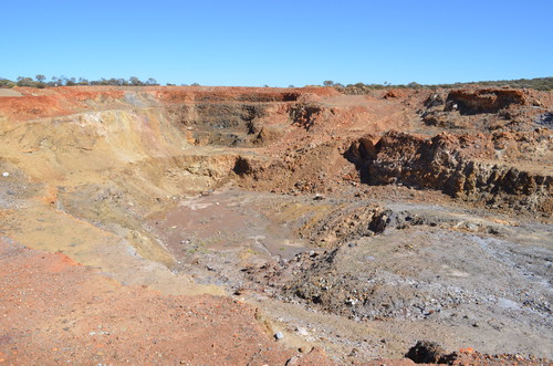


Dalgaranga Mine, Dalgaranga Station, Yalgoo Shire, Western Australia, Australia